
The McKenzie River is a 90-mile (145 km) tributary of the Willamette River in western Oregon in the United States. It drains part of the Cascade Range east of Eugene and flows westward into the southernmost end of the Willamette Valley. It is named for Donald McKenzie, a Scottish Canadian fur trader who explored parts of the Pacific Northwest for the Pacific Fur Company in the early 19th century. As of the 21st century, six large dams have been built on the McKenzie and its tributaries.

The McCloud River is a 77.1-mile (124.1 km) long river that flows east of and parallel to the upper Sacramento River, in Siskiyou County and Shasta County in northern California in the United States. Protected under California's Wild and Scenic Rivers Act (1972), it drains a scenic mountainous area of the Cascade Range, including part of Mount Shasta. It is a tributary of the Pit River, which in turn flows into the Sacramento River. The three rivers join in Shasta Lake, formed by Shasta Dam north of Redding.
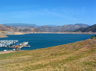
Pine Flat Lake is an artificial lake or reservoir in the Sierra Nevada foothills of eastern Fresno County, California on the western north-south border to the Sierra- and Sequoia National Forests, about 30 mi (48 km) east of Fresno. The lake is managed by the U.S. Army Corps of Engineers (USACE) and is open to boaters, campers & hikers.

The Crooked River is a tributary, 125 miles (201 km) long, of the Deschutes River in the U.S. state of Oregon. The river begins at the confluence of the South Fork Crooked River and Beaver Creek. Of the two tributaries, the South Fork Crooked River is the larger and is sometimes considered part of the Crooked River proper. A variant name of the South Fork Crooked River is simply "Crooked River". The Deschutes River flows north into the Columbia River.

Applegate Lake is a 988-acre (400 ha) reservoir located in the Rogue River–Siskiyou National Forest about 27 miles (43 km) southwest of Medford in the U.S. state of Oregon. It is 16 miles (26 km) south of Oregon Route 238 along Applegate River Road and slightly north of the Oregon–California border. The lake is an impoundment of the Applegate River about 46 miles (74 km) from its confluence with the Rogue River.

Diamond Lake is a natural body of water in the southern part of the U.S. state of Oregon. It lies near the junction of Oregon Route 138 and Oregon Route 230 in the Umpqua National Forest in Douglas County. It is located between Mount Bailey to the west and Mount Thielsen to the east; it is just north of Crater Lake National Park.

Chickahominy Reservoir is located near U.S. Highway 20 100 miles (160.9 km) east of Bend, Oregon, and 32 miles (51.5 km) west of Burns, Oregon, in the United States. It was built as an irrigation reservoir, but is now managed by Oregon Department of Fish and Wildlife as a recreational fishery. The reservoir is very long and is narrow at points, almost pinched at the center.
Howard Prairie Lake is a reservoir located 4,526 feet (1,380 m) above sea level in Jackson County, Oregon, United States. It is 18 miles (29 km) east of Ashland. The lake is formed by the 100-foot (30 m) tall Howard Prairie Dam, which impounds Beaver Creek, in the Klamath River watershed.

Blue River is a tributary of the McKenzie River in Linn and Lane counties in the U.S. state of Oregon. From its source at the confluence of Mann and Wolf creeks in the Cascade Range, it flows generally southwest to join the McKenzie near the community of Blue River. Saddle Dam and Blue River Dam block the river about 2 miles (3 km) from its mouth to form Blue River Reservoir, a multipurpose impoundment built in 1968 by the United States Army Corps of Engineers.

Lookout Point Lake is a large reservoir on the Middle Fork Willamette River in Lane County, Oregon, United States. It was created in 1953 with the construction of Lookout Point Dam.

Dexter Reservoir is a reservoir in Lane County, in the U.S. state of Oregon. It is about 16 miles (26 km) southeast of Eugene on the Middle Fork Willamette River, immediately downriver from Lookout Point Lake, another reservoir. The communities of Dexter and Lowell are near the lake. Oregon Route 58 follows the lake's southern shore, while Pengra Road parallels the lake's northern shore as far east as Lowell.

Blue River Reservoir is an artificial impoundment, about 6 miles (10 km) long, of the Blue River in Lane County in the U.S. state of Oregon. The reservoir is about 1 mile (1.6 km) north of Oregon Route 126 in the Willamette National Forest about 45 miles (72 km) east of Eugene.

Antelope Reservoir is a large body of water impounded for irrigation in a semi-arid region of southeastern Oregon in the United States. Located near the small city of Jordan Valley in Malheur County, it is about 10 miles (16 km) west of Oregon's border with Idaho. Although the lake is formed by a dam across Jack Creek, most of the water enters the reservoir via the Antelope Feeder Canal. It diverts water to the reservoir from nearby Jordan Creek at a point near the Idaho border. Jack Creek, which carries minor outflows from the reservoir, empties into Jordan Creek further downstream.

The South Fork McKenzie River is a tributary, about 31 miles (50 km) long, of the McKenzie River in the U.S. state of Oregon. It begins at about 4,500 feet (1,400 m) above sea level near Mink Lake in the Three Sisters Wilderness of the Cascade Range. Flowing northwest within Lane County, it meets the McKenzie River about 60 miles (97 km) from the larger river's confluence with the Willamette River.

Hills Creek Reservoir, also known as Hills Creek Lake, is an artificial impoundment behind Hills Creek Dam on the Middle Fork Willamette River in the U.S. state of Oregon. The lake is near Oakridge in Lane County about 40 miles (64 km) southeast of Eugene, at the confluence of Hills Creek with the Middle Fork. The reservoir and its watershed lie within the Willamette National Forest.

Hills Creek is a tributary, about 16 miles (26 km) long, of the Middle Fork Willamette River in the U.S. state of Oregon. From its headwaters on Juniper Ridge in the Cascade Range, the creek flows northwest through Lane County and the Willamette National Forest for its entire course.

Jubilee Lake is a 92.33-acre (37.36 ha) man-made lake in the Umatilla National Forest in the northern corner of Union County in the U.S. state of Oregon. It is located 19 miles (31 km) north of Elgin and about 11 miles (18 km) south of the Washington border, at an elevation of 4,761 feet (1,451 m). Its basin spans Union, Umatilla, and Wallowa counties. The lake was made for recreation in 1968 when an earthen dam, 350 feet (110 m) long and 50 feet (15 m) high, was constructed on Motett Creek. A U.S. Forest Service campground at the lake has 53 sites and is the most heavily used campground in the Umatilla National Forest. Fishing and swimming are the most popular activities at the lake. A 2.8-mile (4.5 km) trail around the shore was designated a National Recreation Trail in 1981.

Fall Creek is a 34-mile (55 km) tributary of the Middle Fork Willamette River in Lane County in the U.S. state of Oregon. Beginning in the Cascade Range, the creek flows generally west through the Willamette National Forest to enter the Middle Fork upstream of Jasper, southeast of Springfield and Eugene.

Fall Creek Lake is a reservoir in Lane County, in the U.S. state of Oregon. It is about 22 miles (35 km) southeast of Eugene on Fall Creek, immediately upstream from Unity Bridge, a covered bridge. The communities of Unity, at the bridge site, and Lowell, south of Unity, are near the lake. The unincorporated community of Jasper is further downstream, below the confluence of Fall Creek with the Middle Fork Willamette River.
Thomson Reservoir, also known as Thomson Valley Reservoir, is an irrigation reservoir on the upper East Fork of Silver Creek in the Fremont National Forest, approximately ten miles upstream from Silver Lake, Oregon, in the United States. Constructed in 1930 alongside a dam by the Silver Lake Irrigation District, Thomson Reservoir spans roughly 1800 acres and can hold 7750 acre-feet of water.


