| East Fork Williams Fork [1] | |
|---|---|
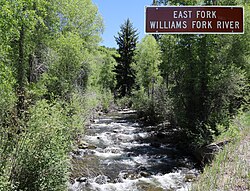 The river just before it goes under County Road 8 in the Routt National Forest | |
 | |
| Physical characteristics | |
| Source | |
| • location | Devils Causeway |
| • coordinates | 40°02′27″N107°09′50″W / 40.04083°N 107.16389°W [1] |
| Mouth | |
• location | Confluence with South Fork Williams Fork |
• coordinates | 40°19′05″N107°24′39″W / 40.31806°N 107.41083°W [1] |
• elevation | 6,558 feet (1,999 meters) [1] |
| Basin features | |
| Progression | Williams Fork—Yampa—Green—Colorado |
| Tributaries | |
| • left |
|
| • right |
|
The East Fork Williams Fork is a tributary of the Williams Fork in north central Colorado in the United States. The river merges with the South Fork Williams Fork to form the Williams Fork. [2]