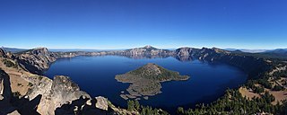
Crater Lake National Park is a national park of the United States located in southern Oregon. Established in 1902, Crater Lake is the fifth-oldest national park in the United States and the only national park in Oregon. The park encompasses the caldera of Crater Lake, a remnant of Mount Mazama, a destroyed volcano, and the surrounding hills and forests.

Newberry National Volcanic Monument was designated on November 5, 1990, to protect the area around the Newberry Volcano in the U.S. state of Oregon. The monument was created within the boundaries of the Deschutes National Forest, which is managed by the U.S. Forest Service, and includes 54,822 acres of lakes, lava flows, and geologic features in central Oregon.

The Deschutes River in central Oregon is a major tributary of the Columbia River. The river provides much of the drainage on the eastern side of the Cascade Range in Oregon, gathering many of the tributaries that descend from the drier, eastern flank of the mountains. The Deschutes provided an important route to and from the Columbia for Native Americans for thousands of years, and then in the 19th century for pioneers on the Oregon Trail. The river flows mostly through rugged and arid country, and its valley provides a cultural heart for central Oregon. Today the river supplies water for irrigation and is popular in the summer for whitewater rafting and fishing.

Newberry Volcano is a large, active, shield-shaped stratovolcano located about 20 miles (32 km) south of Bend, Oregon, United States, 35 miles (56 km) east of the major crest of the Cascade Range, within the Newberry National Volcanic Monument. Its highest point is Paulina Peak. Newberry is the largest volcano in the Cascade Volcanic Arc, with an area of 1,200 square miles (3,100 km2) when its lava flows are taken into account. From north to south, the volcano has a length of 75 miles (121 km), with a width of 27 miles (43 km) and a total volume of approximately 120 cubic miles (500 km3). It was named for the geologist and surgeon John Strong Newberry, who explored central Oregon for the Pacific Railroad Surveys in 1855.

The Twin Lakes are adjacent Lakes Washining and Washinee, commonly referred to as East Twin Lake and West Twin Lake, in Salisbury amidst Connecticut's Northwest Hills.

The Metolius River is a tributary of the Deschutes River in Central Oregon, United States. The river flows north from springs near Black Butte, then turns sharply east, descending through a series of gorges before ending in the western end of Lake Billy Chinook. The unincorporated community of Camp Sherman lies astride the southern end of the river. The name of the river comes from the Warm Springs or Sahaptin word mitula, meaning white salmon and referring to a light colored Chinook salmon and not a whitefish.

The Sky Lakes Wilderness is a wilderness area located in the Rogue River–Siskiyou and Fremont–Winema national forests in the southern Cascade Range of Oregon in the United States. It comprises 116,300 acres (47,100 ha), of which 75,695 acres (30,633 ha) are in the Rogue River–Siskiyou National Forest and 40,605 acres (16,432 ha) are in the Fremont–Winema National Forest. It was established in 1984 under the Wilderness Act of 1964.

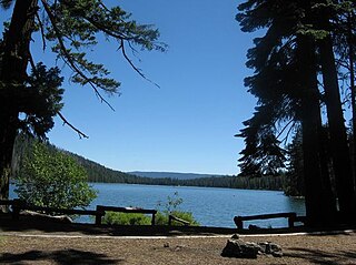
Lake Billy Chinook is a reservoir in Jefferson County in the U.S. state of Oregon. Created by the Round Butte Dam in 1964, Lake Billy Chinook lies in a canyon at the confluence of the Crooked, Deschutes, and Metolius rivers near Culver and Madras. It was named for Billy Chinook, a Native American of the Wasco tribe who traveled alongside American explorers John C. Frémont and Kit Carson in their expeditions of 1843 and 1844.
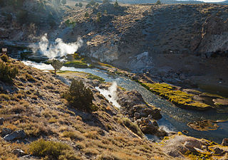
Hot Creek, starting as Mammoth Creek, is a stream in Mono County of eastern California, in the Western United States. It is within the Inyo National Forest.

Diamond Lake is a natural body of water in the southern part of the U.S. state of Oregon. It lies near the junction of Oregon Route 138 and Oregon Route 230 in the Umpqua National Forest in Douglas County. It is located between Mount Bailey to the west and Mount Thielsen to the east; it is just north of Crater Lake National Park.
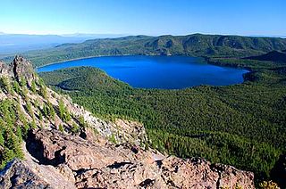
Paulina Lake is one of the twin crater lakes in Newberry Crater, central Oregon, United States. It is located 6,331 feet (1,930 m) above sea level in the Newberry National Volcanic Monument near La Pine. The lake's primary inflow is seepage from East Lake, snow melt, and hot springs, and its outflow is Paulina Creek, a tributary of the Little Deschutes River. It has an area of 1,531 acres (619.6 ha), a volume of 249,850 acre-feet (308,185 dam3), a maximum depth of 250 feet (76.2 m), a shore length of about 6.7 miles (11 km), and a residence time of about 46 years. The lake is classified as mesotrophic, with a transparency of approximately 13.1 feet (3.99 m). It is about 40 feet (12 m) lower and one mile west of its twin, East Lake.

The Paulina Lake Guard Station is a Forest Service building located in the Newberry National Volcanic Monument in Central Oregon. The guard station was built by the Civilian Conservation Corps to house the seasonal assistant ranger responsible for patrolling the forest around Paulina Lake. Because of its rustic architecture, the guard station was listed on the National Register of Historic Places in 1986.
The Paulina Mountains are a mountain range in Deschutes County, Oregon. There are 97 named mountains in the Paulina Mountains, the tallest and most famous one being Paulina Peak, which sits at 7,969 feet in elevation."Paulina Peak serves as the highest point of the Newberry Volcano, a large active stratovolcano that sits just 35 miles east of the crest of the Cascade Range. These summits are actually the remnants of an old crater called the Newberry Crater.

Lemolo Lake is a small lake and reservoir in Douglas County, Oregon in the Umpqua National Forest 30 miles (48 km) north of Crater Lake National Park, on the North Umpqua River. It is part of the Diamond Lake Ranger district, and is administered by the United States Forest Service.
Lake of the Woods is a natural lake near the crest of the Cascade Range in the Fremont–Winema National Forest in southern Oregon in the United States. The lake covers 1,146 acres (4.64 km2). It was named by Oliver C. Applegate in 1870. Today, the Oregon Department of Fish and Wildlife manages the lake's fishery. The small unincorporated community of Lake of the Woods is located on the east shore of the lake. Lake of the Woods is one of southern Oregon's most popular outdoor recreation sites.
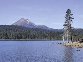
Suttle Lake is a natural lake near the crest of the Cascade Range in central Oregon, United States, covering 253 acres (1.02 km2). It was named in honor of John Settle, whose name was misspelled when the lake was officially recorded as a geographic feature. Today, the lake is located within the Deschutes National Forest and serves as one of central Oregon's most popular outdoor recreation sites, with three large campgrounds and two day-use areas along the north, west, and south shores of the lake. The Oregon Department of Fish and Wildlife regularly stocks the lake with rainbow trout.

Lava Lake lies in the Cascade Range about 25 miles (40 km) west-southwest of Bend in the U.S. state of Oregon. It is a close neighbor of Little Lava Lake, from which it is separated by solidified lava. Lava Lake is at an elevation of 4,740 feet (1,440 m) in the Deschutes National Forest. The lake covers 368 acres (149 ha) to an average depth of 20 feet (6.1 m).

Elliott Corbett Memorial State Recreation Site is a state park along the south shore of Blue Lake Crater in Jefferson County, Oregon, United States. The park is named in honor of Elliott R. Corbett II, who was killed while serving in the United States Army during World War II. It includes 63 acres (25 ha) of wilderness land with very few park facilities. Corbett State Park is administered by the Oregon Parks and Recreation Department.

Paulina Creek Falls is a cascade and plunge waterfall from a streambed draining from Paulina Lake in Newberry National Volcanic Monument, south of Bend, Oregon. The waterfall is notable for its side-by-side drop of 80 feet (24 m) that surrounds a small island at the edge of the cliff.


