Related Research Articles
Osage Township is an inactive township in Miller County, in the U.S. state of Missouri.
Dawt Township is an inactive township in Ozark County, in the U.S. state of Missouri.
Thornfield Township is an inactive township in Ozark County, in the U.S. state of Missouri.
Dry Creek is a stream in Webster County in the Ozarks of southern Missouri. It is a tributary of the James River.
Forkners Hill is an unincorporated community in northern Webster County, in the Ozarks of southern Missouri. The community is situated at the intersection of routes WW and Y, north of the Niangua River, at an elevation of 1250 feet. Conway is four miles to the northeast, in Laclede County.
Olga is an unincorporated community in the southwest corner of Webster County, in the Ozarks of southern Missouri. Olga is located on Missouri Route Z, approximately five miles northwest of Dogwood in northwest Douglas County. Finley Creek flows just north of the community.
Rader is an unincorporated community in the northeast corner of Webster County, in the Ozarks of southwest Missouri. The community is located on Missouri Route ZZ between Conway to the northwest and Grovespring to the southeast. Rader is on the southern floodplain of the Osage Fork Gasconade River.
Susanna is an unincorporated community in northeastern Webster County, in the Ozarks of southwest Missouri.
Teague Creek is a stream in Webster County in the Ozarks of southern Missouri. It is a tributary of the James River. The stream headwaters are at 37°14′02″N92°45′02″W and its confluence with the James is at 37°13′53″N92°51′20″W.
Dallas Township is an inactive township in Webster County, in the U.S. state of Missouri.
Finley Township is an inactive township in Webster County, in the U.S. state of Missouri.
Hazelwood Township is an inactive township in Webster County, in the U.S. state of Missouri.
Niangua Township is an inactive township in Webster County, in the U.S. state of Missouri.
Ozark Township is a defunct township in Webster County, in the U.S. state of Missouri.
Washington Township is an inactive township in Webster County, in the U.S. state of Missouri.
Northview Township is a township in Webster County, in the U.S. state of Missouri.
Diggins Township is a township in Webster County, in the U.S. state of Missouri.
Zenar is a community in southwest Webster County in the Ozarks of southwest Missouri. The location is on the southern edge of the Springfield Plateau at an elevation of 1,503 ft (458 m). The townsite is located southwest of Fordland. The community is located just east of Missouri Route U, 2.5 miles south of U.S. Route 60. The headwaters of Pedelo Creek lie just to the west and the Webster-Christian county line is one-half mile to the south. The community of Olga lies approximately three miles to the east.
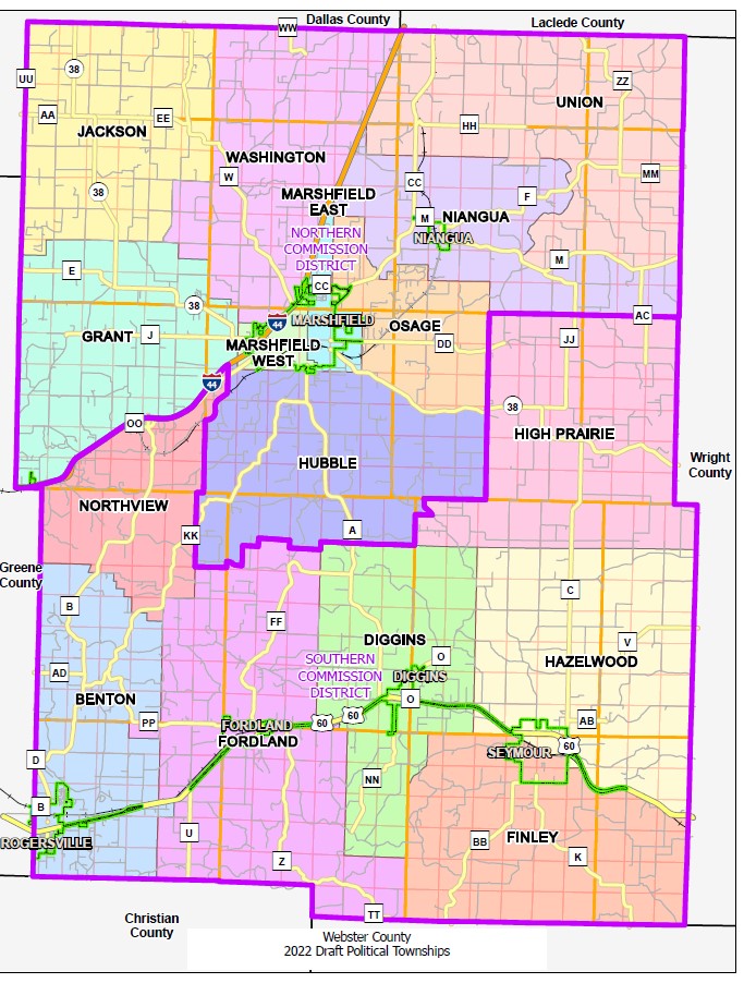
Hubble Township is a township in Webster County, in the U.S. state of Missouri. In 2022, it was created from the portion of East Ozark Township south of Route 38, with the remainder becoming Osage Township. Hubble Township takes its name from the Hubble Fruit Farm.
Osage Township is a township in Webster County, in the U.S. state of Missouri. In 2022, it was created from the portion of East Ozark Township north of Route 38, with the remainder becoming Hubble Township. Osage Township takes its name from the Osage River, the headwaters of which run through the township.
References
- ↑ U.S. Geological Survey Geographic Names Information System: East Ozark Township, Webster County, Missouri
- ↑ 2022 Draft Political Township (Map). Webster County, Missouri. July 2022. Retrieved January 23, 2023.
- ↑ Jones, John (July 27, 2022). "Voting District Updates". The Mail . Marshfield, Missouri. Retrieved January 23, 2023.
- ↑ "Webster County Place Names, 1928–1945". The State Historical Society of Missouri. Archived from the original on June 24, 2016. Retrieved January 2, 2017.
Municipalities and communities of Webster County, Missouri, United States | ||
|---|---|---|
| Cities |  | |
| Village | ||
| Townships | ||
| Unincorporated communities | ||
| Ghost towns | ||
| Former townships | ||
| Footnotes | ‡This populated place also has portions in an adjacent county or counties | |
37°17′32″N92°51′03″W / 37.2922°N 92.8508°W
| | This Webster County, Missouri state location article is a stub. You can help Wikipedia by expanding it. |