Qatar is a peninsula in the east of Arabia, bordering the Persian Gulf and Saudi Arabia, in a strategic location near major petroleum and natural gas deposits. The State of Qatar occupies 11,571 km2 (4,468 sq mi) on a peninsula that extends approximately to 160 km (99 mi) north into the Persian Gulf from the Arabian Peninsula.

The Kingdom of Saudi Arabia is a country situated in West Asia, the largest country on the Arabian Peninsula, bordering the Persian Gulf and the Red Sea. Its extensive coastlines provide great leverage on shipping through the Persian Gulf and the Suez Canal. The kingdom occupies 80% of the Arabian Peninsula. Most of the country's boundaries with the United Arab Emirates (UAE), Oman, and the Republic of Yemen are undefined, so the exact size of the country remains unknown. The Saudi government estimate is at 2,217,949 square kilometres, while other reputable estimates vary between 2,149,690 and 2,240,000 sq. kilometres. Less than 7% of the total area is suitable for cultivation, and in the early 1960s, population distribution varied greatly among the towns of the eastern and western coastal areas, the densely populated interior oases, and the vast, almost empty deserts.

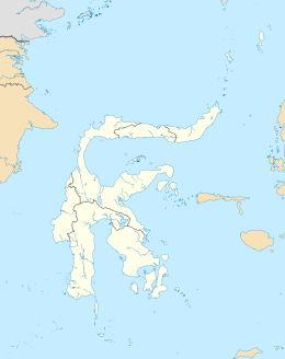
Sulawesi, also known as Celebes, is an island in Indonesia. One of the four Greater Sunda Islands, and the world's 11th-largest island, it is situated east of Borneo, west of the Maluku Islands, and south of Mindanao and the Sulu Archipelago. Within Indonesia, only Sumatra, Borneo, and Papua are larger in territory, and only Java and Sumatra are more populous.
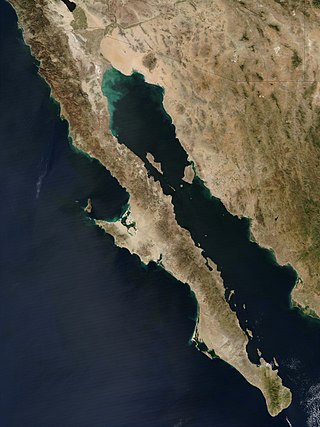
The Baja California peninsula is a peninsula in northwestern Mexico. It separates the Gulf of California from the Pacific Ocean. The peninsula extends from Mexicali, Baja California, in the north to Cabo San Lucas, Baja California Sur, in the south.
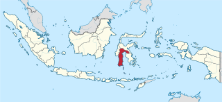
South Sulawesi is a province in the southern peninsula of Sulawesi, Indonesia. The Selayar Islands archipelago to the south of Sulawesi is also part of the province. The capital and largest city is Makassar. The province is bordered by Central Sulawesi and West Sulawesi to the north, the Gulf of Bone and Southeast Sulawesi to the east, Makassar Strait to the west, and Flores Sea to the south.

North Sulawesi is a province of Indonesia. It is mainly located on the Minahasa Peninsula of the island of Sulawesi, south of the Philippines and southeast of Sabah, Malaysia, but also includes various small archipelagoes situated between the Minahasa Peninsula and southern Philippines. It borders the Philippines province of Davao Occidental and Soccsksargen regions to the north, the Maluku Sea to the east, Gorontalo and the Celebes Sea to the west and the Gulf of Tomini to the southwest. The province's furthest extent, the outlying and isolated island of Miangas to its north, is the northernmost island of Indonesia as a bordering with the Philippines.

Southeast Sulawesi, is a province on the island of Sulawesi, forming the southeastern peninsula of that island, together with a number of substantial offshore islands such as Buton, Muna, Kabaena and Wawonii, together with many smaller islands. It is bordered by South Sulawesi and Central Sulawesi to the north, sharing a maritime border with Maluku and North Maluku to the east and East Nusa Tenggara to the south, as well a very narrow maritime border with East Timor to the south. The capital is the city of Kendari, on the east coast of the peninsula.
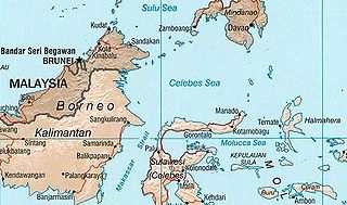
The Celebes Sea or Sulawesi Sea of the western Pacific Ocean is bordered on the north by the Sulu Archipelago and Sulu Sea and Mindanao Island of the Philippines, on the east by the Sangihe Islands chain, on the south by Sulawesi's Minahasa Peninsula, and the west by northern Kalimantan in Indonesia. It extends 420 miles (675 km) north-south by 520 mi (840 km) east-west and has a total surface area of 110,000 square miles (280,000 km2), to a maximum depth of 20,300 feet (6,200 m). South of the Cape Mangkalihat, the sea opens southwest through the Makassar Strait into the Java Sea.

The Gulf of Carpentaria is a sea off the northern coast of Australia. It is enclosed on three sides by northern Australia and bounded on the north by the eastern Arafura Sea, which separates Australia and New Guinea. The northern boundary is generally defined as a line from Slade Point, Queensland in the northeast, to Cape Arnhem on the Gove Peninsula, Northern Territory in the west.

Geologically, the Sunda Shelf is a south-eastern extension of the continental shelf of Mainland Southeast Asia. Major landmasses on the shelf include Bali, Borneo, Java, Madura, and Sumatra, as well as their surrounding smaller islands. It covers an area of approximately 1.85 million km2. Sea depths over the shelf rarely exceed 50 metres and extensive areas are less than 20 metres resulting in strong bottom friction and strong tidal friction. Steep undersea gradients separate the Sunda Shelf from the Philippines, Sulawesi, and the Lesser Sunda Islands.
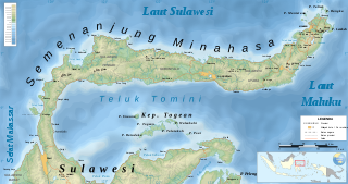
The Minahasa Peninsula, also spelled Minahassa, is one of the four principal peninsulas on the Indonesian island of Sulawesi. It stretches north from the central part of the island, before turning to the east and forming the northern boundary of the Gulf of Tomini and the southern boundary of the Celebes Sea.
The Southeast Peninsula is a peninsula of Sulawesi (Celebes), lying between the Gulf of Tolo and the Gulf of Boni. It is mostly coterminous with the province of Southeast Sulawesi. The largest city on the peninsula is Kendari.

Investigator Strait is a body of water in South Australia lying between the Yorke Peninsula, on the Australian mainland, and Kangaroo Island. It was named by Matthew Flinders after his ship, HMS Investigator, on his voyage of 1801–1802. It is bordered by the Gulf St Vincent in the northeast.

A continental divide is a drainage divide on a continent such that the drainage basin on one side of the divide feeds into one ocean or sea, and the basin on the other side either feeds into a different ocean or sea, or else is endorheic, not connected to the open sea. Every continent on earth except Antarctica has at least one continental drainage divide; islands, even small ones like Killiniq Island on the Labrador Sea in Canada, may also host part of a continental divide or have their own island-spanning divide. The endpoints of a continental divide may be coastlines of gulfs, seas or oceans, the boundary of an endorheic basin, or another continental divide. One case, the Great Basin Divide, is a closed loop around an endorheic basin. The endpoints where a continental divide meets the coast are not always definite since the exact border between adjacent bodies of water is usually not clearly defined. The International Hydrographic Organization's publication Limits of Oceans and Seas defines exact boundaries of oceans, but it is not universally recognized. Where a continental divide meets an endorheic basin, such as the Great Divide Basin of Wyoming, the continental divide splits and encircles the basin. Where two divides intersect, they form a triple divide, or a tripoint, a junction where three watersheds meet.

The following outline is provided as an overview of and introduction to Oceanography.

The Central Indo-Pacific is a biogeographic region of Earth's seas, comprising the tropical waters of the western Pacific Ocean, the eastern Indian Ocean, and the connecting seas.
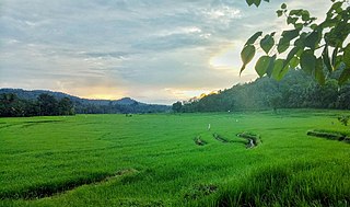
Sinjai Regency is a regency of the South Sulawesi province of Indonesia. The regency, which is separated from the Bone Regency to its north by the River Tangka, covers an area of 819.96 km2. It had a population of 228,936 at the 2010 census and 259,478 at the 2020 census. The official estimate of population as of mid-2024 was 273,559. It includes the Nine Islands in the Gulf of Bone off the east coast of the southern peninsula of Sulawesi; this archipelago forms an administrative district within the regency. The regency's principal town lies at Sinjai, a port situated on the east coast of that peninsula.

Gorontalo is a province of Indonesia on the island of Sulawesi. Located on the Minahasa Peninsula, Gorontalo was formerly part of the province of North Sulawesi until its inauguration as a separate province on 5 December 2000. The province is bordered by the provinces of North Sulawesi to the east and Central Sulawesi to the west, as well sharing a maritime border with the Philippines in the Sulawesi Sea to the north, and a coastline on the Gulf of Tomini to the south. The provincial capital, as well as the main gateway to the province and its most populated city, is Gorontalo. The size is comparable to Vanuatu.
