
The North Platte River is a major tributary of the Platte River and is approximately 716 miles (1,152 km) long, counting its many curves. In a straight line, it travels about 550 miles (890 km), along its course through the U.S. states of Colorado, Wyoming, and Nebraska.

The Fryingpan River is a tributary of the Roaring Fork River, approximately 42 miles (68 km) long, in west central Colorado in the United States.

The Blue River is a tributary of the Colorado River, approximately 65 miles (105 km) long, in the U.S. state of Colorado.
Muddy Creek is a tributary of the Colorado River, approximately 60.5 miles (97.4 km) long, in north central Colorado in the United States.
The Eagle River is a tributary of the Colorado River, approximately 60.5 miles (97.4 km) long, in west central Colorado in the United States.
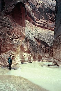
The Paria River is a tributary of the Colorado River, approximately 95 miles (153 km) long, in southern Utah and northern Arizona in the United States. It drains a rugged and arid region northwest of the Colorado, flowing through roadless slot canyons along part of its course.

Plateau Creek is a tributary of the Colorado River, approximately 50 miles (80 km) long, located in western Colorado in the United States. It drains a cattle ranching valley, known as Plateau Valley, north of the Grand Mesa and east of Grand Junction.

The Arikaree River is a 156-mile-long (251 km) river in the central Great Plains of North America. It lies mostly in the American state of Colorado, draining land between the North and South Forks of the Republican River, and it flows into the North Fork in Nebraska after flowing a short distance through Kansas. It is a designated area within the Colorado Natural Areas Program to protect native and uncommon species that may be endangered or threatened.

The Indian Pass Wilderness is 32,418-acre (13,119 ha) wilderness area under the administered by the Bureau of Land Management. The reserve is located in the very southeastern part of the Chocolate Mountains, in the southeastern part of California, just to the west of the Colorado River in the Lower Colorado River Valley. It adjoins the Picacho Peak Wilderness to the south, and the Imperial National Wildlife Refuge to the east.

The Puerco River or Rio Puerco is a tributary of the Little Colorado River in northwestern New Mexico and northeastern Arizona. It flows through arid terrain, including the Painted Desert.

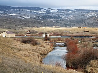
The Bear River is a 22.7-mile-long (36.5 km) tributary of the Yampa River. Its source is in the Flat Tops Wilderness above Stillwater Reservoir in Garfield County, Colorado. The Bear River flows northeast into Routt County and joins the Yampa River just east of the town of Yampa.

The Mancos River, formerly also El Rio de San Lazaro, is an 85.4-mile-long (137.4 km) northeast tributary of the San Juan River. It flows from the confluence of West Mancos River and East Mancos River near Mancos, Colorado and joins the San Juan near Four Corners Monument in New Mexico.

Apishapa River is a 139-mile-long (224 km) tributary of the Arkansas River that flows from a source near West Spanish Peak in southern Colorado. It joins the Arkansas east of Fowler, Colorado. A U.S. Geological Survey (USGS) station, #07119500, located along this river near Fowler measures the river's discharge.

Saint Charles River is a 64.6-mile-long (104.0 km) tributary of the Arkansas River that flows from a source near Saint Charles Peak in the Wet Mountains of southern Colorado. It joins the Arkansas east of Pueblo, Colorado.

East Fork Arkansas River is a 20.6-mile-long (33.2 km) tributary of the Arkansas River that flows from a source in the Mosquito Range of central Colorado. It joins with Tennessee Creek to form the Arkansas River west of Leadville, Colorado.
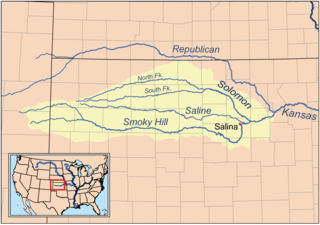
The North Fork Smoky Hill River is a river in the central Great Plains of North America. A tributary of the Smoky Hill River, it flows from eastern Colorado into western Kansas.
East Mancos River is a 12.2-mile-long (19.6 km) tributary of the Mancos River in Montezuma County, Colorado. The river flows west from a source in the La Plata Mountains to a confluence with the West Mancos River that forms the Mancos River.

East Fork Eagle River is an 8.6-mile-long (13.8 km) tributary of the Eagle River in Eagle County, Colorado. The river flows from a source on Chicago Ridge in the White River National Forest to a confluence with the South Fork Eagle River that forms the Eagle River.
South Fork Eagle River is a 6.9-mile-long (11.1 km) tributary of the Eagle River in Eagle County, Colorado. The river flows from a source east of Tennessee Pass in the White River National Forest to a confluence with the East Fork Eagle River that forms the Eagle River.
Middle Fork Cimarron River is a 10.3-mile-long (16.6 km) tributary of the Cimarron River in Colorado. The river's source is east of Coxcomb Peak in the Uncompahgre Wilderness of Hinsdale County. It joins the East Fork Cimarron River in Gunnison County to form the Cimarron River.


