
Castle Morpeth was a local government district and borough in Northumberland, England. Its administrative centre was the town of Morpeth.

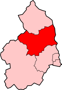
Tynedale is an area and former local government district in south-west Northumberland, England. The district had a resident population of 58,808 according to the 2001 Census. Its main towns were Hexham, Haltwhistle and Prudhoe. The district contained part of Hadrian's Wall and the southern part of Northumberland National Park.
Alnwick was a local government district of Northumberland, England. Its council was based in Alnwick town and the district had a population of 31,029 according to the 2001 census.

Darney is a small lunar impact crater that is located on the region of the Moon where the Mare Nubium joins the Oceanus Procellarum. It was named after French astronomer Maurice Darney. To the south is the lava-flooded crater Lubiniezky. The southern rim of Darney is attached to a series of low ridges that extend to the southwest.
Holwick is a small village in Teesdale, north-east England. Located in the Pennine hills, it consists of a few houses spread along a road in the pattern of a linear settlement. As the population taken at the 2011 Census was less than 100, details are maintained in the parish of Lunedale.
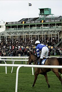
Newcastle Racecourse is a horse racing course located at Gosforth Park in Newcastle upon Tyne, England, owned by Arena Racing Company. It stages both flat and National Hunt racing, with its biggest meeting being the Northumberland Plate held annually in June.

Wood Islands Provincial Park is a provincial park in Prince Edward Island, Canada, situated immediately south of Wood Islands and 55 km (34 mi) from Charlottetown, the provincial capital. The park has a surface of 0.1 km2 (0.039 sq mi).
Lingarabay is a small coastal settlement on Harris, in the Outer Hebrides of Scotland. It is located on the rocky east coast of South Harris, about 2 miles (3.2 km) northeast of Rodel.
Renous-Quarryville is a Canadian local service district in Northumberland County, New Brunswick. It is located 25 mi upstream of Miramichi, and is situated where the Renous River, and the Indiantown brook. discharges into the Southwest Miramichi River. It is named for the Renous river, and settlement, as well as Quarryville's quarry, hence the name "Renous-Quarryville local service district."

Northumberland County Council is a unitary authority in North East England. The population of the non-metropolitan unitary authority at the 2011 census was 316,028.
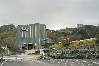
Callow Rock quarry is a limestone quarry located in Shipham Gorge between Cheddar and Shipham on the Mendip Hills, Somerset, England.
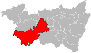
The Canton of Darney is a rural French administrative and electoral grouping of communes in the Vosges département of eastern France and in the region of Grand Est. The Canton of Darney has its administrative centre at Darney.
Cateran Hole is a circa 35m length cave set in the Gritstone of Cateran Hill in Northumberland. It lies about 4 miles due north of Eglingham, and can be reached by lining up the tall mast behind the farm with the left-hand end of the wood to the side of the Quarry House farm, then walking on this bearing.

Milecastle 21 was a milecastle of the Roman Hadrian's Wall. The site was identified by measurement only, as the milecastle's remains have been totally removed. This is probably due to extensive quarrying at the site, which now lies under pasture.

West Fleetham is a small hamlet in Northumberland, England situated about 4 miles from Seahouses and 2 miles from Chathill railway station.

RAF Blakelaw was a Royal Air Force station which acted as headquarters for No.13 Group during the Second World War and which was located in Blakelaw, Northumberland.
Forrestfield is a small settlement in North Lanarkshire, Scotland. It is located on the A89 road, 3 kilometres (1.9 mi) east of Caldercruix and 4 kilometres (2.5 mi) west of Blackridge. Until 1956 the settlement had a railway station on the former Bathgate and Coatbridge Railway. This line reopened in 2010 as the Airdrie–Bathgate rail link, although Forrestfield station was not reopened. Cairneyhill Quarry, a whinstone quarry operated by Tarmac, lies 0.5 kilometres (0.31 mi) to the south of Forrestfield.
The North British Distillery is a grain whisky distillery located in the Gorgie area of Edinburgh, Scotland. Established by a group of independent distillers in 1885, it is now a joint venture company between Diageo and Edrington Group. It is Edinburgh's last working distillery, widely known as the "NB".
Wark railway station is a disused railway station which served the village of Wark on Tyne, Northumberland, England. Located on the Border Counties Railway, the station was possibly opened on 1 December 1859, but was definitely open by 1 April 1860. The station was originally connected to the village by a wooden bridge over the River Tyne but this was replaced by an iron bridge in 1878. There was a single platform, a small goods shed with a signal box being added in 1896. It was closed to passengers on 15 October 1956 and completely on 1 September 1958.
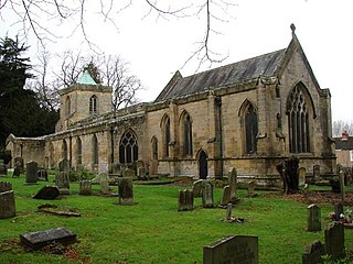
St Mary's, also known as St Mary the Virgin, is an ancient Grade I listed Church of England parish church located in Morpeth, Northumberland. The church is to the south of the River Wansbeck in Morpeth, which is an area known as High Church. The oldest remaining parts of the structure belong to the Transitional Early English style of the mid to late 12th century, but the church is mostly in the 14th century style. The church, which was the main Anglican place of worship in the area until the 1840s, has been restored several times after being destroyed by the Scandinavians, Scottish and Cromwellians in the 10th and later centuries.
