
Slovenia is situated at the crossroads of central and southeast Europe, touching the Alps and bordering the Adriatic Sea. The Alps—including the Julian Alps, the Kamnik–Savinja Alps and the Karawank chain, as well as the Pohorje massif—dominate northern Slovenia along its long border to Austria. Slovenia's Adriatic coastline stretches approximately 47 km (29 mi) from Italy to Croatia. Its part south of Sava river belongs to Balkan peninsula – Balkans.
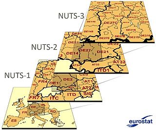
Nomenclature of Territorial Units for Statistics or NUTS is a geocode standard for referencing the administrative divisions of countries for statistical purposes. The standard, adopted in 2003, is developed and regulated by the European Union, and thus only covers the EU member states in detail. The Nomenclature of Territorial Units for Statistics is instrumental in the European Union's Structural Funds and Cohesion Fund delivery mechanisms and for locating the area where goods and services subject to European public procurement legislation are to be delivered.

Northeast Italy is one of the five official statistical regions of Italy used by the National Institute of Statistics (ISTAT), a first level NUTS region and a European Parliament constituency. Northeast encompasses four of the country's 20 regions:
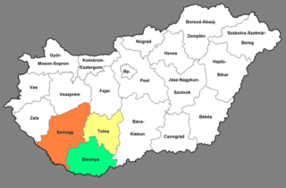
Southern Transdanubia is a statistical region of Hungary. It is part of the Transdanubia region. Southern Transdanubia includes the counties of Somogy, Tolna, and Baranya. Its capital and largest city is Pécs. It borders Croatia to the south, the Southern Great Plain NUTS 2 region to the east, the Central Transdanubia NUTS 2 region to the north, and the Western Transdanubia NUTS 2 region to the north-west.

The Northern Great Plain is a statistical region of Hungary. It is part of the Great Plain and North region. The Northern Great Plain includes the counties of Hajdú-Bihar, Jász-Nagykun-Szolnok, and Szabolcs-Szatmár-Bereg, with a total area of 17,749 km2 (6,853 sq mi) and a population of around 1.5 million. The region is in the eastern part of Hungary. It borders northern Hungary to the north, Ukraine to the north-east, Romania to the south-east, the Southern Great Plain region of Hungary to the south, and central Hungary to the west. The region's centre, and capital city is Debrecen, the second largest city within Hungary.

Severozapaden, is a region of Bulgaria. The capital is the city of Pleven. The region has the lowest-ranked economy in Bulgaria and the European Union, with a GDP per capita (PPS) of €9,300 or 31% of EU28 average (2017). It includes five administrative divisions or oblasts: Vidin Province, Vratsa Province, Montana Province, Lovech Province and Pleven Province.

Severen Tsentralen Planning Region is a planning region of Bulgaria, encompassing five Bulgarian provinces: Ruse, Veliko Tarnovo, Gabrovo, Targovishte and Razgrad.

The Central Sava Valley is a valley in the Sava Hills and a geographic region along the Sava in central Slovenia, now constituting the Central Sava Statistical Region. The region consists of three municipalities: Zagorje ob Savi, Trbovlje, and Hrastnik. Several coal mines operated in the Central Sava Valley, although all except the Trbovlje–Hrastnik Mine are now defunct. It is surrounded by the Sava Hills, with Kum on the right side of the Sava and Black Peak on Čemšenik Pasture at the left side of the Sava, as its highest peaks.

The statistical regions of Slovenia are 12 administrative entities created in 2000 for legal and statistical purposes.

Western Slovenia is one of the two NUTS-2 Regions of Slovenia. The region forms the western part of the country and includes the cities of Ljubljana, Kranj, Koper and Nova Gorica. It is the wealthier of the two regions of Slovenia.

The Gorizia Statistical Region is a statistical region in western Slovenia, along the border with Italy. It is named after the Italian town of Gorizia.
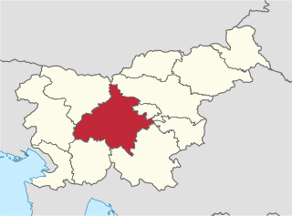
The Central Slovenia Statistical Region is a statistical region in central Slovenia.
The Drava Statistical Region is a statistical region in Slovenia. The largest city in the region is Maribor. The region's name comes from the Drava River and includes land on both banks along its course through Slovenia as well as the Pohorje mountains in the northeast of the region. The Drava is used for the production of hydroelectricity and the fertile land around it is used for agriculture. The share of job vacancies in all available jobs is among the highest in Slovenia and the region has a positive net migration rate but a very high natural decrease, which means an overall decrease in the population.
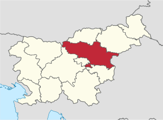
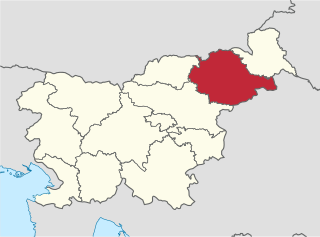
The Savinja Statistical Region is a statistical region in Slovenia. The largest town in the region is Celje. It is named after the Savinja River. The region is very diverse in natural geography; it mainly comprises the wooded mountainous terrain attractive to tourists, the fertile Lower Savinja Valley with good conditions for growing hops, the Kozje Hills, and the Velenje Basin with lignite deposits, used for electricity production. In 2013 the region invested more than EUR 127 million in environmental protection. In 2013, the region accounted for 14% of enterprises created and 8% of enterprises shut down. The region has good natural conditions for agriculture. In 2013 this region had more than 11,000 farms, which is 15% of all farms in Slovenia, ranking the region right behind the Drava Statistical Region. In agricultural area utilised and livestock, the region was also in second place. The region is a well-known and popular tourist destination. In 2012, tourist arrivals and overnight stays in the region represented 11.1% of all tourist arrivals in Slovenia and 15.0% of all overnight stays. On average, tourists spent four nights there.
In the NUTS codes of Slovenia (SI), the three levels are:

The Central Sava Statistical Region is a statistical region in Slovenia. This statistical region in the Sava Hills is the smallest region in the country in terms of both area and population. In early-2010 almost 41,700 people lived on 264 km2, meaning that together with the Central Slovenia Statistical Region it is the most densely populated statistical region. The natural and geographic features of this region create conditions for industrial activities and more than a third of gross value added is still generated by manufacturing, mining, and other industry. In 2013, the region once again recorded the highest negative annual population growth rate (−11.9‰), which was mainly a result of migration to other statistical regions. Among all statistical regions in 2013, this region had the highest negative net migration between regions; namely, −9.5. This region also stands out by age of mothers at childbirth. In 2013 first-time mothers in the region were on average 28.5 years old, whereas first-time mothers in the Central Slovenia Statistical Region were on average 1 year older. In the same year, the number of unemployed persons increased further. The registered unemployment rate was among the highest in the country (16.6%). In comparison with other regions, this is 7 percentage points more than in the region with the lowest registered unemployment rate, Upper Carniola, and almost 1 percentage point less than in the region with the highest unemployment rate, the Mura Statistical Region. According to the labour migration index, this is the most residential statistical region. In 2013, 60% of people in the region worked in their region of residence, and 40% worked in another region.

The Lower Sava Statistical Region is a statistical region in Slovenia. It has good traffic accessibility and is located in the Sava and Krka Valleys, with hilly areas with vineyards and an abundance of water. It is the second-smallest statistical region in Slovenia. The only nuclear power plant in the country and Čatež spa are located in the region. The region annually spends EUR 22 million on environmental protection. In 2013, the employment rate in the region was 57.5%. The region was characterized by the largest difference between the employment rate for men and for women. In 2013 this region also stood out in number of convicted persons per 1,000 population (8.3).
The Sava Hills are the eastern part of the Slovene Prealps. They are oriented in the east-west direction and are located to the north and south of the Sava River in central and eastern Slovenia, among the Ljubljana Basin to the west, the Celje Basin to the north, the Lower Carniola valley system and the Krško Basin to the south, and the Sotla Hills to the east. They cover an area of 1,909 square kilometres (737 sq mi) and are the largest Slovenian mesoregion.
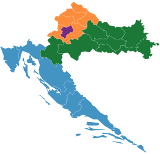
Northern Croatia or North Croatia refers to the northern parts of Croatia, encompassing Zagreb, Varaždin, Međimurje, Zagorje and Koprivnica-Križevci counties, including the cities of Zagreb, Varaždin, Čakovec, Krapina, Koprivnica and Križevci. The region is home to the Kajkavian dialect, which some consider to be a separate language of its own. The region borders Hungary to its north-east and Slovenia to its north-west.

Eastern Slovakia is one of the four NUTS-2 Regions of Slovakia. It was created at the same time as were the Košice and Prešov regions. Eastern Slovakia is the least developed of the four NUTS-2 regions of Slovakia, with its GDP per capita being 54% of the European Union average.
