Holly Hill is a city in Volusia County, Florida, United States. The population was 11,659 at the 2010 census. Holly Hill's city limits lie entirely on the Florida mainland, unlike the larger cities on either side of it, Daytona Beach and Ormond Beach, which encompass both the mainland and the barrier island across the Halifax River.

Five Points in Columbia, South Carolina is a shopping, restaurant, and nightlife area that attracts customers from the nearby University of South Carolina and throughout the Columbia metropolitan area. It is the center for the city's annual St. Patrick’s Day Festival.
The Olde English District is one of eleven tourism districts of South Carolina encompassing Chester, Chesterfield, Fairfield, Kershaw, Lancaster, and York counties as well as the cities and towns of Camden, Chester, Chesterfield, Clover, Kershaw, Lancaster, Pageland, Rock Hill, Winnsboro, and York.

Pores Knob is a mountain peak located in Wilkes County, North Carolina, USA.

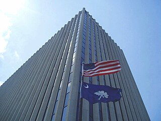
Jefferson Square, an office complex in downtown Columbia, South Carolina, is the headquarters of the state's Department of Health and Human Services, which oversees the Medicaid program for South Carolinians. Located at 1801 Main St. in the city's historic Arsenal Hill neighborhood, the complex includes a 12-story, 150,000 sq ft (14,000 m2). office tower, a two-story courtyard plaza and God's Blessing Cafe, a locally owned restaurant. Also on the Jefferson Square block are the offices of Wilson-Kibler real estate, two parking garages, a parking lot, and the Arsenal Hill Associate Reformed Presbyterian Church.

The Episcopal Diocese of Upper South Carolina (EDUSC) is a diocese in The Episcopal Church.

The 5th Congressional District of South Carolina is a congressional district in northern South Carolina bordering North Carolina. The district includes all of Cherokee, Chester, Fairfield, Kershaw, Lancaster, Lee, Union and York counties and parts of Newberry, Spartanburg and Sumter counties. Outside the rapidly growing cities of Rock Hill, Fort Mill, and Lake Wylie the district is mostly rural and agricultural. The district borders were contracted from some of the easternmost counties in the 2012 redistricting.

WRHI is a news/talk radio station in Rock Hill, South Carolina. It broadcasts on AM frequency 1340 with a simulcast on 100.1 FM and is under ownership of OTS Media Group. Its studios and transmitter are both located separately in Rock Hill.
Eagle Field is a soccer-specific stadium located in Rock Hill, South Carolina, United States, on the campus of Winthrop University.
The Come See Me festival is an annual Spring festival hosted in Rock Hill, South Carolina.
WNSC-FM is a National Public Radio station in Rock Hill, South Carolina. A member of ETV Radio, it carries programming from ETV Radio's all-news network.
Rock Hill/York County Airport is a general aviation and reliever airport of Charlotte-Douglas International Airport located 5 miles (7 km) from the central business district of Rock Hill, in York County, South Carolina, United States. It is owned and operated by the City of Rock Hill, but York County is also represented on the Airport Commission.
White Rock is an unincorporated community in northwestern Richland County, South Carolina, United States, a few miles north of Lake Murray. Although it is unincorporated, it has a post office, with the ZIP Code of 29177. The population of the ZCTA for ZIP Code 29177 was 463 at the outdated 2000 census. The Lowman Home retirement home was established in 1911. Nearby is the Lake Murray Golf Center Nine-Hole Par 3 driving range, and mini golf. In the 21st century, the White Rock area has been transformed by the addition and expansion of several significant subdivisions, Waterfall, affluent Portrait Hill, Lake Murray Elementary, the new Chapin Middle School, Spring Hill High School, home to Lake Murray Docks and the Center for Advanced Technical Studies, all in Lexington & Richland County School District Five.
Tirzah is an unincorporated community in York County, South Carolina, United States, halfway between the city of York and Rock Hill. The elevation of Tirzah is 703 ft.
Smith or Smiths Turnout is an unincorporated community in southern York County, South Carolina located south of Rock Hill and northwest of Edgemoor near the Chester County line. The elevation of Smith is 531 feet.
State Route 36 (SR 36) is a 28.6-mile-long (46.0 km) state highway, broken in two segments. In Unicoi County, it serves as the hidden concurrency of U.S. Route 19W; in Washington and Sullivan counties, it serves as a stand alone secondary road connecting the cities of Johnson City and Kingsport.


