Telegraph Creek is a small community located off Highway 37 in Northern British Columbia at the confluence of the Stikine River and Telegraph Creek. The only permanent settlement on the Stikine River, it is home to approximately 250 members of Tahltan First Nation and non-native residents. The town offers basic services, including Anglican and Catholic churches, a general store, a post office, a clinic with several nurses on-call around the clock, two Royal Canadian Mounted Police officers, and a k-9 school. Steep river banks and rocky gorges form the terraced nature of the geography.

Unorganized North Algoma District is an unorganized area in northeastern Ontario, Canada, comprising all areas in Algoma District, north of the Sault Ste. Marie to Elliot Lake corridor, which are not part of an incorporated municipality or a First Nation. It covers 44,077.03 km2 (17,018.24 sq mi) of land, and had a population of 5739 in 2016.

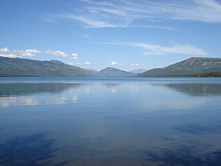
Dease Lake is a small community located in the Cassiar Country of the Northern Interior of British Columbia, Canada. Located a few hours south of the Yukon border, it is located on Stewart–Cassiar Highway at the south end of the lake of the same name. Dease Lake is the last major centre before the Alaska Highway, and also the junction to Telegraph Creek and the Grand Canyon of the Stikine. Dease Lake Indian Reserve No. 9 is located nearby and is under the governance of the Tahltan First Nation band government.
Eddontenajon/Iskut Village Airport, formerly TC LID: CBU2, was a registered aerodrome located 0.6 nautical miles north of Eddontenajon, British Columbia, Canada.
Iskut is a small, mostly aboriginal community in the Stikine Country of northwestern British Columbia. It is located on Highway 37, at the north end of Eddontenajon Lake just south of Dease Lake and the crossing of the Stikine River. The community of Eddontenajon used to be located nearby.

Boya Lake Provincial Park is a provincial park in British Columbia, Canada, located 120 km north-by-northwest of the community of Dease Lake near BC Highway 37. Boya Lake is named for Charlie Boya, a First Nations man from the area.
Choquette Hot Springs Provincial Park is a provincial park in the Stikine Country region of northwestern British Columbia, Canada. Despite the park's name, the official and most commonly used name of the springs it was established to protect is Stikine River Hot Springs. The park gets its name by the springs' proximity to Choquette Bar, site of the first gold strike of the Stikine Gold Rush of 1861 and named for Alexander "Buck" Choquette, the strike's discoverer.
Kinaskan Lake Provincial Park is a provincial park in British Columbia, Canada, located at the south end of Kinaskan Lake along the Stewart-Cassiar Highway near Mowdade Lake and southeast of Mount Edziza. At the south end of the park, the Iskut River, of which the lake is an expansion, spills over 40-foot Cascade Falls. The park is approximately 800 ha. in size.
Todagin South Slope Provincial Park is a provincial park in British Columbia, Canada, located on the west side of Todagin Creek to the east of Kinaskan Lake in the Stikine Country, to the south of the community of Dease Lake. Created in 2001, it contains c. 3557 ha.
Tahltan, or Goon-da-chagga or Goon-tdar-shaga is an unincorporated locality and Indian Reserve community of the Tahltan people located west of Telegraph Creek in northern British Columbia, Canada, near the confluence of the Stikine and Tahltan Rivers. The local First Nations government is the Tahltan Band Council. The specific name of the Indian Reserve is Tahltan Indian Reserve No. 1. Other reserves in the immediate vicinity, also governed by this band, are Tahltan Forks Indian Reserve No. 5, Upper Tahltan Indian Reserve No. 4 and Hiusta's Meadow Indian Reserve No. 2.
Beggerlay Canyon is a canyon on the Stikine River in northwestern British Columbia, Canada, located northeast of the communities of Iskut, British Columbia and Eddontenajon Lake. The rapids near Beggerlay Canyon are regarded as the most difficult on the Grand Canyon of the Stikine.
The Nazko First Nation is a First Nations government of the Dakelh people in the north-central Interior of British Columbia. Its reserves are located around the community of Nazko, British Columbia, which is 120 km west of Quesnel and southwest of Prince George.
The Porcupine River is a left tributary of the Stikine River in northwestern British Columbia, Canada, entering that stream south of the confluence of the Anuk River and above the confluence of the Iskut.
The Stikine Plateau is a plateau in northern British Columbia, Canada. It lies between the Boundary Ranges of the Coast Mountains on the west and southwest and the Cassiar Mountains along its northeast, and between the Skeena Mountains on its south and southeast and the Jennings and Nakina Rivers on the north.
The Tahltan First Nation, also known as the Tahltan Indian Band, is a band government of the Tahltan people. Their main community and reserves are located at Telegraph Creek, British Columbia. Their language is the Tahltan language, which is an Athabaskan language also known as Nahanni, is closely related to Kaska and Dunneza. Their Indian and Northern Affairs Canada band number is 682. The Tahltan First Nation is joined with the Iskut First Nation in a combined tribal council-type organization known as the Tahltan Nation.
The Klastline Plateau is a plateau in the Stikine Country of the Northern Interior of British Columbia, Canada. A subplateau of the Stikine Plateau, it is located between the Stikine River (N), the upper Iskut River (S), Mess Creek (W) and the Klappan River (E). The Skeena Mountains are to the south, the Tahltan Highland to the west, the Spatsizi Plateau to the east, and the Tanzilla Plateau to the north, on the other side of the Stikine. The Spatsizi and Tanzilla Plateaus, and the Tahltan Highland, are also part of the Stikine Plateau.
Cascade Falls is a waterfall on the Iskut River in the Stikine Country of northwestern British Columbia, Canada, to the southeast of Mount Edziza and near the Stewart-Cassiar Highway. About 40 feet tall, it is located at the south end of Kinaskan Lake Provincial Park.

Buck Lake is a hamlet in central Alberta, Canada within the County of Wetaskiwin No. 10. It is located on Highway 13, approximately 109 kilometres (68 mi) southwest of Edmonton. It is located on the shore of Buck Lake (Alberta).

The Volcano, also known as Lava Fork volcano, is a small cinder cone in the Boundary Ranges of the Coast Mountains in northwestern British Columbia, Canada. It is located approximately 60 km (40 mi) northwest of the small community of Stewart near the head of Lava Fork. With a summit elevation of 1,656 m (5,433 ft) and a topographic prominence of 311 m (1,020 ft), it rises above the surrounding rugged landscape on a remote mountain ridge that represents the northern flank of a glaciated U-shaped valley.
Dauphin River is a community in the Canadian province of Manitoba.


