Edna, Iowa | |
|---|---|
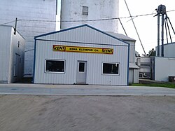 The Edna Elevator | |
 Edna  Edna | |
| Coordinates: 43°23′06″N96°05′40″W / 43.38500°N 96.09444°W | |
| Country | United States |
| State | Iowa |
| County | Lyon |
| Township | Liberal |
| Area | |
• Total | 0.05 sq mi (0.1 km2) |
| • Land | 0.05 sq mi (0.1 km2) |
| • Water | 0 sq mi (0 km2) |
| Elevation | 1,414 ft (431 m) |
| Time zone | UTC-6 (Central (CST)) |
| • Summer (DST) | UTC-5 (CDT) |
| ZIP code | 51246 |
| Area code | 712 |
| GNIS feature ID | 456245 [1] |
Edna is an unincorporated town in Liberal Township, Lyon County, Iowa, United States.
Edna is located on the western border of Liberal Township in Lyon County. It is located 6 miles (10 km) southeast of Rock Rapids, the county seat.
The town consists of about 10 houses, a couple of outbuildings and sheds, and in the center of town stands the Edna Grain Elevator.
