Edwardsville, Indiana

Last updated

Edwardsville, Indiana
USA Indiana location map.svg
Red pog.svg
Edwardsville
Usa edcp location map.svg
Red pog.svg
Edwardsville
Coordinates: 38°17′03″N85°54′34″W / 38.28417°N 85.90944°W / 38.28417; -85.90944
Country United States
State Indiana
County Floyd
Township Georgetown
Elevation
[1]
912 ft (278 m)
ZIP code
47122
FIPS code 18-20476 [2]
GNIS feature ID434034 [1]

Edwardsville is an unincorporated community in Georgetown Township, Floyd County, Indiana. The Duncan Tunnel is located at Edwardsville.

Contents

History

Edwardsville was platted in 1853 by Henry H. Edwards, and named for him. [3] A post office was established at Edwardsville in 1858, and remained in operation until it was discontinued in 1905. [4]

Geology

The Edwardsville Formation is a geological structure in the Borden Group, of the Lower Mississippian sub system, [5] (Osagean, late Tournaisian). Crinoids fossils can be found in the formation. [6]

Related Research Articles

<span class="mw-page-title-main">Georgetown Township, Floyd County, Indiana</span> Township in Indiana, United States

Georgetown Township is one of five townships in Floyd County, Indiana. As of the 2010 census, its population was 9,632 and it contained 3,733 housing units.

<span class="mw-page-title-main">Lafayette Township, Floyd County, Indiana</span> Township in Indiana, United States

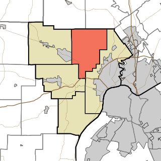
Lafayette Township is one of five townships in Floyd County, Indiana. As of the 2010 census, its population was 7,449 and it contained 2,856 housing units, although it remains one of the two townships in the county without an incorporated community.

<span class="mw-page-title-main">Carr Township, Clark County, Indiana</span> Township in Indiana, United States

Carr Township is one of twelve townships in Clark County, Indiana. As of the 2020 census, its population was 4,830 and it contained 1,794 housing units.

<span class="mw-page-title-main">Bennettsville, Indiana</span> Unincorporated community in Indiana, United States

Bennettsville is an unincorporated community in Carr Township, Clark County, Indiana.

<span class="mw-page-title-main">Blue Lick, Indiana</span> Unincorporated community in Indiana, United States

Blue Lick is an unincorporated community in Monroe Township, Clark County, Indiana, United States.

<span class="mw-page-title-main">Broom Hill, Indiana</span> Unincorporated community in Indiana, United States

Broom Hill is an unincorporated community in Carr Township, Clark County, Indiana.

<span class="mw-page-title-main">Hamburg, Clark County, Indiana</span> Unincorporated community in Indiana, United States

Hamburg is an unincorporated community in Silver Creek Township, Clark County, Indiana. Parts of Hamburg are within the municipal boundaries of Clarksville and Sellersburg.

<span class="mw-page-title-main">Otisco, Indiana</span> Unincorporated community in Indiana, United States

Otisco is an unincorporated community in Charlestown Township, Clark County, Indiana.

<span class="mw-page-title-main">Owen, Indiana</span> Unincorporated community in Indiana, United States

Owen is an unincorporated community in Owen Township, Clark County, Indiana.

<span class="mw-page-title-main">Watson, Indiana</span> Unincorporated community in Indiana, United States

Watson is an unincorporated community in Utica Township, Clark County, Indiana.

Grantsburg is an unincorporated community and Census-designated place in Union Township, Crawford County, Indiana.

Pilot Knob is an unincorporated community in Jennings Township, Crawford County, Indiana.

Temple is an unincorporated community in Sterling Township, Crawford County, Indiana, United States.

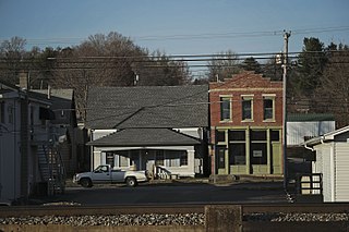
Scottsville is an unincorporated community in Lafayette Township, Floyd County, Indiana.

<span class="mw-page-title-main">Borden Formation</span> Mississippian period geologic formation in Appalachia and Midwest United States

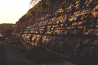
The Mississippian Borden Formation is a mapped bedrock unit in Kentucky, Indiana, Illinois, Ohio, West Virginia, and Tennessee. It has many members, which has led some geologists to consider it a group rather than a formation.

<i>Agaricocrinus americanus</i> Species of echinoderm

Agaricocrinus americanus, the mushroom crinoid, is a species of extinct crinoid, known only from its fossils, which are found in the U.S. states of Indiana, Tennessee and Kentucky. They date back to the Lower Mississippian, about 345 million years ago.

The Edwardsville Formation is a geological structure in the Borden Group, of the Lower Mississippian sub system,. Crinoids fossils can be found in the formation.

<i>Onychocrinus</i> Extinct genus of crinoids

Onychocrinus is an extinct genus of crinoids.

The Rancheria Formation is a geologic formation in the Sacramento and San Andres Mountains of New Mexico, the Franklin Mountains of southern New Mexico and western Texas, and the Hueco Mountains of western Texas. It preserves fossils dating back to the Visean Age of the Mississippian.

References

  1. 1 2 U.S. Geological Survey Geographic Names Information System: Edwardsville, Indiana
  2. "U.S. Census website". United States Census Bureau . Retrieved January 31, 2008.
  3. History of the Ohio Falls Cities and Their Counties: Precincts of Jefferson County, Ky. General histories of Clark and Floyd counties, Ind. New Albany and Floyd County. Clark County and Jeffersonville. L. A. Williams & Company. 1882. p.  273.
  4. "Floyd County". Jim Forte Postal History. Retrieved September 5, 2014.
  5. "Compendium of Rocks Units in Indiana - A Revision". igws.indiana.edu.
  6. Crinoids from the Edwardsville Formation (Lower Mississippian) of Southern Indiana. William I. Ausich and N. Gary Lane, Journal of Paleontology, November 1982, Volume 56, Number 6, pages 1343-1361 (abstract)