Algeria, since December 18, 2019, is divided into 58 wilayas (provinces). Prior to December 18, 2019, there were 48 provinces. The 58 provinces are divided into 1,541 baladiyahs (municipalities). The name of a province is always that of its capital city.

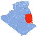
Tamanrasset or Tamanghasset is the largest province (wilaya) in Algeria. It was named after its province seat, Tamanrasset. The province has two national parks, more than any other in Algeria. They are Tassili n'Ajjer National Park and Ahaggar National Park. The province is the largest in Algeria as it is 557,906 km2 large.

Illizi is a large province (wilaya) in the south-eastern corner of Algeria named after its eponymous seat. It borders Ouargla Province to the north, Tunisia to the extreme northeast, Libya to the east, Djanet Province to the south and, to the west, In Salah Province and Tamanrasset Province. As of the 2008 census, the province had a population of 52,333 and an annual growth rate of 4.5%.
Tassili Airlines is an Algerian passenger airline, based in Algiers, owned by Sonatrach, the national state-owned oil company of Algeria.
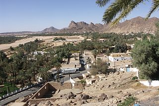
Djanet is an oasis city, and capital of Djanet District as well as of Djanet Province, southeast Algeria. It is located 412 km (256 mi) south of Illizi. According to the 2008 census it has a population of 14,655, up from 9,699 in 1998, and an annual population growth rate of 4.3%. It is inhabited by the Kel Ajjer Tuareg people.
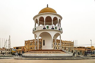
El Oued, Souf or Oued Souf is a city, and the capital of El Oued Province, in Algeria. The oasis town is watered by an underground river, hence its name is El Oued which enables date palm cultivation and the rare use of brick construction for housing. As most roofs are domed, it is known as the "City of a Thousand Domes".

Hassi Messaoud is a town in Ouargla Province, eastern Algeria, located 85 kilometres (53 mi) southeast of Ouargla. As of 2008 it had a population of 45,147 people, up from 40,360 in 1998, and an annual population growth rate of 1.1%, the lowest in the province. Oil was discovered there in 1956 and the town's prominence has grown rapidly since then; it is considered as the First Energy town in Algeria where all the big oil and gas companies have offices and bases. It is an oil refinery town named after the first oil well. A water well, dug in 1917, can be found on the airport side of town. Today there are over 800 wells within a 25 kilometres (16 mi) radius of the town.
Béchar is the capital city of Béchar Province, Algeria. It is also a commune, coextensive with Béchar District, of Béchar Province. In 2008 the city had a population of 165,627, up from 134,954 in 1998, with an annual growth rate of 2.1%. The commune covers an area of 5,050 square kilometres (1,950 sq mi).

Illizi is a town and commune, coextensive with Illizi District, situated in the south-eastern part of Algeria, and capital of Illizi Province. According to the 2008 census it is the largest commune by population in the province, with a population of 17,252, up from 10,163 in 1998, and an annual population growth rate of 5.5%, the highest in the province. It is one of the gates to the Tassili N'Ajjer National Park with caves situated under the sands containing prehistoric drawings dating from 6000 years BC. There is a hotel and two camping sites, as well as many local tourist agencies.
Bordj El Houasse is a town and commune in Djanet District, Djanet Province, Algeria. It is part of Djanet District. According to the 2008 census it has a population of 2,963, up from 2,185 in 1998, and an annual population growth rate of 3.2%. Its municipal code is 3305.
In Amenas is a district in Illizi Province, Algeria. It was named after its capital, In Amenas. As of the 2008 census it is the largest district in the province by area and second-largest by population.

Djanet is a district in Djanet Province, Algeria. It was named after its capital, Djanet. It is the largest district of the province in population and in area.
Azelouaz is a village in the commune of Djanet, in Djanet District, Illizi Province, Algeria. It is in the same valley as the district capital Djanet, which is 2.5 kilometres (1.6 mi) to the south. Along with the other localities near Djanet it lies on the south-western edge of the Tassili n'Ajjer mountain range.
El Mihan is a village in the commune of Djanet, in Djanet District, Illizi Province, Algeria. It is in the same valley as the district capital Djanet, which is 1 kilometre (0.62 mi) to the north. Along with the other localities near Djanet it lies on the south-western edge of the Tassili n'Ajjer mountain range.
Adjahil is a village in the commune of Djanet, in Djanet District, Illizi Province, Algeria. It is in the same valley as the district capital Djanet, which is 3 kilometres (1.9 mi) to the north. Along with the other localities near Djanet it lies on the south-western edge of the Tassili n'Ajjer mountain range.

Tin El Koum is a village in the commune of Djanet, in Djanet District, Illizi Province, Algeria. It is located in the same valley as Ghat in Libya, deep within the south-eastern Tassili N'Ajjer mountain range, east of Djanet. It is the location of a border crossing into Libya which is controlled by independent Tuareg militias in the Libyan civil war.

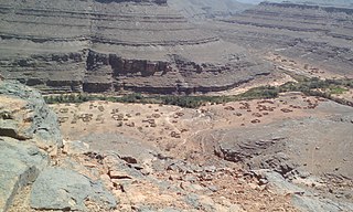
Iherir is a village in the commune of Bordj El Houasse, in Djanet District, Illizi Province, Algeria. It is in a river valley (wadi) named Oued Iherir near the center of the Tassili n'Ajjer mountain range, 121 kilometres (75 mi) south of the provincial capital Illizi. The area has been populated since Neolithic times; the population living in the valley has been continuously over 1000 during the 20th century.
Djanet Lachmet is an Algerian novelist and actress.
The wilaya of Djanet is an Algerian province created in 2019, previously, a delegated wilaya created in 2015. It is located in the Algerian Sahara.

Sebiba is the term used in Algeria to designate a festival and the Tuareg people's dance performed on this occasion and accompanied by female drummers in the Sahara oasis of Djanet in the Tassili n'Ajjer region in southern Algeria. The dance originated among the descendants of black African slaves and is part of the celebrations for the Islamic Ashura Festival. The dance was recognized by UNESCO in 2014 for its significance to humanity's intangible cultural heritage.