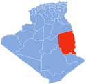
Tamanrasset or Tamanghasset is a province (wilaya) in southern Algeria. It is named after its province seat, Tamanrasset. The province is the home of two national parks: Ahaggar National Park and Tassili n'Ajjer National Park. It is the largest province in Algeria, with an area of 336,839 km2.

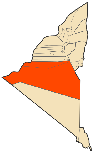
Illizi is a large province (wilaya) in the south-eastern corner of Algeria named after its eponymous seat. It borders Ouargla Province to the north, Tunisia to the extreme northeast, Libya to the east, Djanet Province to the south and, to the west, In Salah Province and Tamanrasset Province. As of the 2008 census, the province had a population of 52,333 and an annual growth rate of 4.5%.
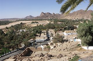
Djanet is an oasis city, and capital of Djanet District as well as of Djanet Province, southeast Algeria. It is located 412 km (256 mi) south of Illizi. According to the 2008 census it has a population of 14,655, up from 9,699 in 1998, and an annual population growth rate of 4.3%. It is inhabited by the Kel Ajjer Tuareg people.

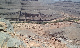
Illizi is an Algerian town and commune, coextensive with Illizi District, situated in the south-eastern part of Algeria, and capital of Illizi Province. According to the 2008 census it is the largest commune by population in the province, with a population of 17,252, up from 10,163 in 1998, and an annual population growth rate of 5.5%, the highest in the province. It is one of the gates to the Tassili N'Ajjer National Park with caves situated under the sands containing prehistoric drawings dating from 6000 years BC. There is a hotel and two camping sites, as well as many local tourist agencies.
Bordj El Houas is a town and commune in Djanet District, Djanet Province, Algeria. It is part of Djanet District. According to the 2008 census it has a population of 2,963, up from 2,185 in 1998, and an annual population growth rate of 3.2%. Its municipal code is 3305.
In Amenas is a district in Illizi Province, Algeria. It was named after its capital, In Amenas. As of the 2008 census it is the largest district in the province by area and second-largest by population.

Adrar District is a district of Adrar Province, Algeria. With a population of 88,266, it is the most populated district in the province.

Aougrout District is a district of Timimoun Province, Algeria. According to the 2008 census it has a population of 28,869.

Aoulef District is a district of Adrar Province, Algeria. According to the 2008 census it has a population of 54,909.

Bordj Badji Mokhtar District is a district of Bordj Baji Mokhtar Province, Algeria. According to the 2008 census, it has a population of 20,930.

Fenoughil District is a district of Adrar Province, Algeria. According to the 2008 census it has a population of 29,540.
Reggane District is a district of Adrar Province, Algeria. According to the 2008 census it has a population of 33,540.

Tsabit District is a district of Adrar Province, Algeria. According to the 2008 census, it has a population of 17,207.

Timimoun District is a district of Timimoun Province, Algeria. According to the 2008 census it has a population of 41,279.
Azelouaz is a village in the commune of Djanet, in Djanet District, Illizi Province, Algeria. It is in the same valley as the district capital Djanet, which is 2.5 kilometres (1.6 mi) to the south. Along with the other localities near Djanet it lies on the south-western edge of the Tassili n'Ajjer mountain range.
El Mihan is a village in the commune of Djanet, in Djanet District, Illizi Province, Algeria. It is in the same valley as the district capital Djanet, which is 1 kilometre (0.62 mi) to the north. Along with the other localities near Djanet it lies on the south-western edge of the Tassili n'Ajjer mountain range.
Adjahil is a village in the commune of Djanet, in Djanet District, Illizi Province, Algeria. It is in the same valley as the district capital Djanet, which is 3 kilometres (1.9 mi) to the north. Along with the other localities near Djanet it lies on the south-western edge of the Tassili n'Ajjer mountain range.
Eferi is a village in the commune of Djanet, in Djanet District, Illizi Province, Algeria. Along with the other localities near Djanet it lies at the south-western edge of the Tassili n'Ajjer mountain range.

Tin El Koum is a village in the commune of Djanet, in Djanet District, Illizi Province, Algeria. It is located in the same valley as Ghat in Libya, deep within the south-eastern Tassili N'Ajjer mountain range, east of Djanet. It is the location of a border crossing into Libya which is controlled by independent Tuareg militias in the Libyan civil war.

The wilaya of Djanet is an Algerian province created in 2019, previously, a delegated wilaya created in 2015. It is located in the Algerian Sahara.