
Lake and Peninsula Borough is a borough in the state of Alaska. As of the 2020 census, the population was 1,476, down from 1,631 in 2010. The borough seat of King Salmon is located in neighboring Bristol Bay Borough, although is not the seat of that borough. The most populous community in the borough is the census-designated place of Port Alsworth. With an average of 0.017 inhabitants per square kilometre, the Lake and Peninsula Borough is the second least densely populated organized county-equivalent in the United States; only the unorganized Yukon-Koyukuk Census Area has a lower density.

The Alaska Peninsula National Wildlife Refuge is a United States National Wildlife Refuge in southwestern Alaska whose use is regulated as an ecological-protection measure. It stretches along the southern coast of the Alaska Peninsula, between the Becharof National Wildlife Refuge on its east and the end of the peninsula at False Pass in the west. In between, however, it is broken into sections by lands of the Aniakchak National Monument and Izembek National Wildlife Refuge. The refuge is administered from offices in King Salmon, Alaska and was established to conserve Alaska Peninsula brown bears, caribou, moose, marine mammals, shorebirds, other migratory birds and fish, and to comply with treaty obligations.

The Karluk River is a stream, 24 miles (39 km) long, on Kodiak Island in the U.S. state of Alaska. It begins at Karluk Lake in the Kodiak National Wildlife Refuge and flows north and then northwest through Karluk Lagoon to the Shelikof Strait at Karluk.

The Chilkoot River is a river in Southeast Alaska, United States, that extends about 20 miles (32 km) from its source and covers a watershed area of 100 square miles (260 km2). The source of the river is in the Takshanuk Mountains to the west and the Freebee glacier and unnamed mountains to the east. From its source, the upper reach of the river extends approximately 16 miles (26 km) to the point where it enters Chilkoot Lake. From the downstream end of the lake, the lower reach of the river flows for about 1.5 miles (2.4 km) until it enters the Chilkoot Inlet, a branch at the northern end of the Lynn Canal.
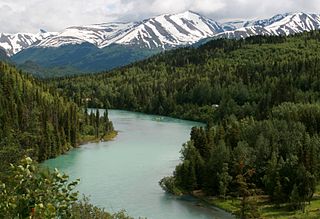
The Kenai River called Kahtnu in the Dena'ina language, is the longest river in the Kenai Peninsula of southcentral Alaska. It runs 82 miles (132 km) westward from Kenai Lake in the Kenai Mountains, through the Kenai National Wildlife Refuge and Skilak Lake to its outlet into the Cook Inlet of the Pacific Ocean near Kenai and Soldotna.
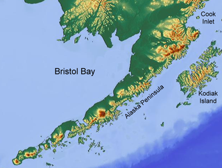
Bristol Bay is the easternmost arm of the Bering Sea, at 57° to 59° North 157° to 162° West in Southwest Alaska. Bristol Bay is 400 km (250 mi) long and 290 km (180 mi) wide at its mouth. A number of rivers flow into the bay, including the Cinder, Egegik, Igushik, Kvichak, Meshik, Nushagak, Naknek, Togiak, and Ugashik.

The Kvichak River (Yup'ik: Kuicaraq) is a large river, about 50 miles (80 km) long, in southwestern Alaska in the United States. It flows southwest from Lake Iliamna to Kvichak Bay, an arm of Bristol Bay, on the Alaska Peninsula. The communities of Igiugig and Levelock lie along the Kvichak River. The Kvichak is navigable along its entire length, and is used as a short cut by boats getting between Cook Inlet and Bristol Bay via the Lake Iliamna portage.

Naknek River is a stream, 35 miles (56 km) long, in the Bristol Bay Borough of the U.S. state of Alaska. It flows west from Naknek Lake to empty into Kvichak Bay, an arm of Bristol Bay. The river and lake are both known for their sockeye and other salmon.

The Alagnak River is a 64-mile (103 km) tributary of the Kvichak River in the U.S. state of Alaska. It has a catchment area of approximately 1400 square mi (3600 km2). It is located in central Lake and Peninsula Borough.

Togiak River is a stream, 48-mile (77 km) long, in the southwestern part of the U.S. state of Alaska. It begins at Togiak Lake in the Togiak Wilderness and flows southwest to Togiak Bay, 2 miles (3.2 km) east of Togiak.
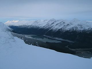
The Chilkoot Lake, in the Tlingit Indians region of Alaska, is also spelt Chilcoot Lake. Its other local names are the Akha Lake and Tschilkut S(ee), meaning "Chilkoot Lake". It is in Haines Borough, Alaska. Chilkoot also means "big fish". The lake has a ‘Recreation Site’ at its southern end near the outlet to the Chilkoot River, which is set amidst the Sitka spruce trees. Chilkoot River flows from the lake for a short length and debouches into the Lutak Channel at the head of the Chilkoot inlet near Haines. Chilkoot village, a settlement of Chilkoot Indians existed at the outlet of the lake, which was called Tschilkut or Tananel or Chilcoot; the lake is named after this village. This village is now a camping area developed by the State Parks and Outdoor Recreation Division of the Alaska Department of Natural Resources. The lake is a popular location for Kayaking.

Southwest Alaska is a region of the U.S. state of Alaska. The area is not exactly defined by any governmental administrative region(s); nor does it always have a clear geographic boundary.
The Kanektok River is a 75-mile (121 km) stream in southwestern Alaska in the United States. Beginning in the Ahklun Mountains at Kagati and Pegati lakes, it flows westward into Kuskokwim Bay on the Bering Sea at the city of Quinhagak. Almost all of the river's course lies within the Togiak National Wildlife Refuge. The Quinhagak Village Corporation owns the land bordering the lowermost 17 miles (27 km) of the river.
The King Salmon River is a 35-mile (56 km) tributary of the Ugashik River in the U.S. state of Alaska. Beginning at Mother Goose Lake in the Aleutian Range, it flows northwest to meet the larger river near the upper reaches of Ugashik Bay. The lake and the upper course of the King Salmon lie within the Alaska Peninsula National Wildlife Refuge. The river's gravel bottom and braided channels are ideal for the many king salmon that spawn in its waters, but they limit navigation to small skiff.
The Koyuk River is a river on the Seward Peninsula of western Alaska, in the United States. The river originates in the interior of the peninsula, at the Lost Jim Lava Flow of the Bering Land Bridge National Preserve, where it flows southeast towards the mouth of Norton Bay on Norton Sound. The native village of Koyuk is located at its mouth. The two major tributaries are the Peace and Salmon rivers; other tributaries include Dime and Sweepstakes.
Crescent Porter Hale (1872–1937) was an American industrialist who was involved in the canned salmon industry in Bristol Bay, Alaska throughout his adult life.
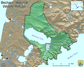
Becharof National Wildlife Refuge is a National Wildlife Refuge in the Aleutian Range of the Alaska Peninsula of southwestern Alaska. It is adjacent to Katmai National Park and Preserve. This national wildlife refuge, which covers an area of 1,200,000 acres (4,900 km2), was established in 1980 to conserve major brown bears, salmon, migratory birds, caribou, marine birds, and mammals and to comply with treaty obligations. It lies primarily in the east-central part of Lake and Peninsula Borough, but extends eastward into the mainland portion of Kodiak Island Borough. The refuge is administered from offices in King Salmon.

Egegik Bay is a bay located just 69.1 miles from Dillingham in Alaska and the northeastern arm of the Bristol Bay. The Egegik village is located on a high bluff along the southern shore of the Egegik River at the upper extent of Egegik Bay. The nearest places to Egegik Bay are Coffee Point, Coffee Point, Goose Point, Egegik Airport, and Bartletts Airport.
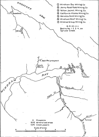
Windham Bay is located 45 miles (72 km) southeast of Juneau, in the U.S. state of Alaska. Windham Bay is listed as site 6 within Southeast Alaska's Zone 3 of the Alaska Dept. of Environmental Conservation's Geographic Response Strategy oil spill response plan. Part of the bay is a protected wilderness area; the Chuck River Wilderness, established in 1990 by the United States Congress, covers an area of 74,506 acres (30,152 ha). The Chuck River flows into Windham Bay, which has a protected anchorage north of Port Houghton, where the historic Chuck Mining Camp once operated.
The Eagle River is a stream, 8 miles (13 km) long, in the borough of Wrangell in the U.S. state of Alaska. Heading at Eagle Lake in the Coast Mountains, it flows northwest through part of the Tongass National Forest into Eagle Bay on the Bradfield Canal. Near the midpoint of its course, the river passes through Little Eagle Lake. On the shore opposite Eagle Bay and the Eagle River mouth, the Harding River enters Bradfield Canal.


