History
Through the centuries, Egem has had multiple names. In the oldest documents it was found to be named Heddeghem (1571), later it was also mentioned as Edeghem (1629), Hettegem (1638), Eedegem (1763), Eghem (1779) and Eegem (1842).
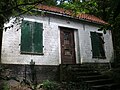
Etymologically, Flemish toponyms ending with –gem refer to a Germanic compound of –haim, meaning ‘home’ or ‘residence’, and a derivative ending –inga. The first part of the name "Egem" is commonly assigned to the Germanic name of Haid, Hait or Heit. In its totality, the compound Haidingahaim meant ‘residence of the followers or tribal members of Frank Haid’, degenerated into Heddeghem. The locality name belongs to the group of ingahemnames who are older than regular hemnames. Egem was founded in the early centuries of the Merovingian era (6th-7th century), and thus has an older origin than Bambrugge. Egem was probably a secluded homestead which was not too great, and was later absorbed by the rapidly faster developing Bambrugge.

Ardooie is a municipality in the Belgian province of West Flanders. The municipality comprises the towns of Ardooie proper and Koolskamp. In 2006 Ardooie had a total population of 9,147. The local inhabitants are called Ardooienaren. During the First World War Hitler was stationed in Ardooie quartered with a family. He painted some of the buildings and the countryside.

Erpe-Mere is a municipality located in the Belgian province of East Flanders in the Denderstreek. The municipality comprises the towns of Aaigem, Bambrugge, Burst, Erondegem, Erpe, Mere, Ottergem and Vlekkem. There is also a hamlet in Bambrugge: Egem. Erpe-Mere is crossed by 2 brooks, the Molenbeek and the Molenbeek-Ter Erpenbeek. In 2022 Erpe-Mere had a total population of 20,127. The total area is 34.03 km2. The current mayor of Erpe-Mere is Hugo De Waele, from the CD&V party.

Temse is a municipality in East Flanders, Belgium.
Engstingen is a municipality in the Tübingen administrative region (Regierungsbezirk) in Baden-Württemberg, Germany. It lies in the Swabian Jura (plateau), about 15 kilometres (9.3 mi) south of Reutlingen.

Spring Beck is a minor watercourse flowing near and through the village of Weybourne in the north of the county of Norfolk.

Oherville is a farming commune in the Seine-Maritime department in the Normandy region in northern France.
The Neue Welt is a sub-district of Münchenstein, in the canton of Basel-Country in Switzerland.
The development of urban centres in the Low Countries shows the process by which the Low Countries, a region in Western Europe, evolved from a highly rural outpost of the Roman Empire into the largest urbanised area north of the Alps by the 15th century CE. As such, this article covers the development of Dutch and Flemish cities beginning at the end of the migration period till the end of the Dutch Golden Age.

Aaigem is a village belonging to the municipality of Erpe-Mere. It is located in the province of East Flanders, Belgium. The village has some 2000 inhabitants. Aaigem was an independent municipality with an area of 7.32 square kilometers till 1976.
Bambrugge is a sub-municipality of Erpe-Mere in Flanders. It is located on the Molenbeek in the Denderstreek, southeast of East Flanders and belongs to the Arrondissement of Aalst. It is bordered by the sub-municipalities of Vlekkem, Ottergem, Mere, Aaigem and Burst and the municipality of Sint-Lievens-Houtem. Bambrugge has 1575 inhabitants as of 1 January 2003 and has an area of 2.89 km. The population density is 545 inhabitants / km ². Bambrugge has also a hamlet: Egem.
Burst is a sub-municipality of Erpe-Mere in Belgium. It is located on the Molenbeek in the Denderstreek, southeast of East Flanders and belongs to the Arrondissement of Aalst. It is bordered by the sub-municipalities of Bambrugge and Aaigem, as well as the municipalities of Herzele and Sint-Lievens-Houtem. Burst had 2968 inhabitants on 1 January 2003 and an area of 3.83 km. The population density was 776 / km ².
Erpe is a sub-municipality of Erpe-Mere in Flanders, Belgium, on the Molenbeek-Ter Erpenbeek in the Denderstreek in the southeast of East Flanders and belongs to Arrondissement of Aalst. The sub-municipality is bordered by the sub-municipalities of Mere, Ottergem, and Erondegem and the municipalities Lede and Aalst. Erpe had 4903 inhabitants as of 1 January 2003 and an area of 8.28 km2 (3.20 sq mi). The population density is 592/km2 (1,530/sq mi).
Mere is a sub-municipality of Erpe-Mere in Flanders. It is located on the Molenbeek-Ter Erpenbeek in the Denderstreek in the southeast of East Flanders and belongs to Arrondissement of Aalst. It is bordered by the sub-municipalities of Erpe, Ottergem, Bambrugge and Aaigem and the municipalities Haaltert and Aalst. Mere has 5033 inhabitants as of 1 January 2003 and an area of 5.77 km. The population density is 873 inhabitants / km ².

Opbrakel is a village and deelgemeente (sub-municipality) of the municipality of Brakel. It is located in the Denderstreek in the province of East Flanders in Belgium. It used to be an independent municipality until 1971 when it was merged into Brakel.
Erondegem is a sub-municipality of Erpe-Mere in Flanders, Belgium. It is located on the Molenbeek in the Denderstreek, southeast of East Flanders and belongs to the Arrondissement of Aalst. It is bordered by the sub-municipalities of Erpe and Ottergem and the municipalities of Sint-Lievens-Houtem and Lede. Erondegem has 1628 inhabitants as of 1 January 2003 and an area of 3.17 km. The population density is 513 inhabitants / km ².
Ottergem is a sub-municipality of Erpe-Mere in Flanders, Belgium. It is located on the Molenbeek in the Denderstreek, southeast of East Flanders and belongs to the Arrondissement of Aalst. The sub-municipality is bordered by the sub-municipalities of Erondegem, Erpe, Mere, Bambrugge and Vlekkem and the municipality Sint-Lievens-Houtem. Ottergem has 500 inhabitants as of 1 January 2003 and an area of 1.55 km. The population density is 322 inhabitants / km².
Vlekkem is a sub-municipality of Erpe-Mere in Flanders, Belgium. It is located on the Molenbeek in the Denderstreek, southeast of East Flanders and belongs to the Arrondissement of Aalst. The sub-municipality is bordered by the hamlet Egem of the sub-municipality Bambrugge, the sub-municipality Ottergem and the municipality Sint-Lievens-Houtem. Vlekkem has 292 inhabitants as of 1 January 2003 and an area of 1.22 km. The population density is 240 inhabitants / km².

Den Dotter is a 205 hectare nature reserve in the sub-municipalities of Aaigem and Heldergem in the East Flemish Denderstreek, Belgium.
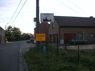
Papegem is a village in the municipality of Lede located in the Belgian province of East Flanders in the Denderstreek. It has an area of 0.58 km². The Wellebeek which flows there belongs to the basin of the Molenbeek which originates from the Upper Scheldt, and flows through Erpe-Mere. In the past the Wellebeek was called the Papegemsche beek. It is bordered by the sub-municipalities of Oordegem, Smetlede and Impe, as well as the municipalities of Sint-Lievens-Houtem and Erpe-Mere (sub-municipality Erondegem, despite the small size of Papegem. In Papegem the Sint-Macharius Chapel can be found. Papegem belongs to the deanery of Herzele-Houtem.

The Molenbeek is a brook in the Denderstreek, Belgium. The stream has a length of approximately 22 kilometers. The source of the Molenbeek is located in Grotenberge and the delta is in nearby Wichelen. This brook is not to be confused with the 25-km-lomg Molenbeek-Ter Erpenbeek which is also in Erpe-Mere. The 25-km brook is part of the Molenbeek Erpe-Mere drainage basin.
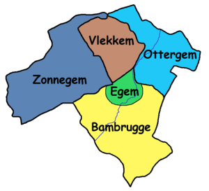 Localisation of Egem in Bambrugge and the surrounding sub-municipalities
 Localisation of Egem in Erpe-Mere