Eibenstock Dam

Last updated
Eibenstock Dam
Eibenstock reservoir (aka).jpg
Location Erzgebirgskreis, Germany
Coordinates 50°31′24″N12°35′21″E / 50.52333°N 12.58917°E / 50.52333; 12.58917 Coordinates: 50°31′24″N12°35′21″E / 50.52333°N 12.58917°E / 50.52333; 12.58917
Construction began1974–1987
Dam and spillways
ImpoundsZwickauer Mulde, Rähmerbach, Geidenbach, Weißbach, Rohrbach
Height (foundation)65.50 m (214.9 ft)
Height (thalweg)57 m (187 ft)
Length307.5 m (1,009 ft)
Elevation at crest543.00 m (1,781.50 ft) AMSL
Width (crest)7.7 m (25 ft)
Dam volume273,000 m3 (9,600,000 cu ft)
Reservoir
Total capacity82.9×10^6 m3 (67,200 acre⋅ft)
Active capacity74.65×10^6 m3 (60,520 acre⋅ft)
Catchment area 200 km2 (77 sq mi)
Surface area370 ha (910 acres)
Normal elevation539.60 m (1,770.3 ft)
Power Station
Installed capacity 1.7 MW (2,300 hp)

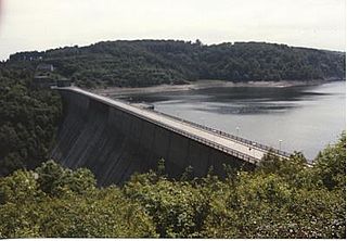
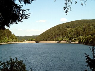
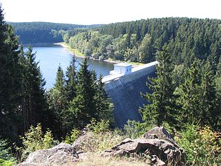
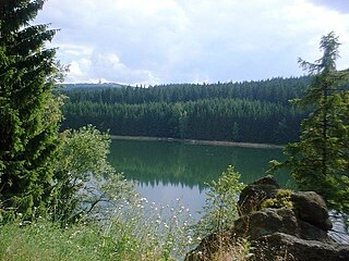
Eibenstock Dam (German : Talsperre Eibenstock) near Eibenstock in the Ore Mountains, Germany, is the largest dam in the Free State of Saxony in terms of the height of the dam above the valley floor, and its reservoir is the largest in volume in Saxony. [1] The dam impounds the waters of the Zwickauer Mulde and supplies drinking water to the region of Chemnitz and Zwickau, as well as providing flood protection, delivering extra water during times of drought and, to a lesser extent, generating electricity from hydropower. Its dimensions make it the second largest drinking water reservoir in Germany's new federal states.

Contents

In order to make way for its construction, the inhabitants of the village of Muldenhammer (also called Windischhammer or Windischthal), whose former buildings (10 homes, 1 wood pulp factory, 1 large estate for the breeding of Höhenfleckrinder cattle and a paper mill) lie today under the water surface, had to be resettled. Many of them moved to new houses that were built in Eibenstock. In addition, the Chemnitz–Aue–Adorf railway between Wolfsgrün and Schönheide Ost was interrupted. The Schönheiderhammer tunnel on that stretch of the route was flooded. At low water levels the old portals of the tunnel can still be seen. [2] Likewise, the branch line from Eibenstock unt. Bf. to Eibenstock ob. Bf. had to be closed. This section, the only standard gauge railway in Saxony with an incline of 1:20, was once known as the Eibenstock Ramp (Steilstrecke Eibenstock). [3]

The water jump of the Eibenstock dam Wasserschanze der Trinkwassertalsperre Eibenstock.jpg
The water jump of the Eibenstock dam

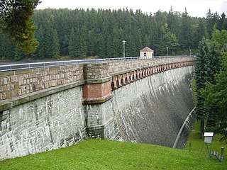
The barrier itself is a straight gravity dam made of concrete. It was built between 1974 and 1984; it was taken into service in 1982 and completed in 1987. The first partial impoundment had already been carried out by 1980.

The dam has an upstream auxiliary dam (Schönheiderhammer Dam) and four subsidiary upstream basins (Rähmerbach, Geidenbach, Weißbach, Rohrbach).

Above the dam is an observation point offering a view across the reservoir. The dam itself is not accessible to the public. Bathing and water sports are also banned, because the dam impounds a drinking water reservoir.

See also

Related Research Articles

Sihl river in Switzerland, tributary of the Limmat

The Sihl is a Swiss river that rises near the Druesberg mountain in the canton of Schwyz, and eventually flows into the Limmat in the centre of the city of Zürich. It has a length of 73 km (45 mi), including the Sihlsee reservoir, through which the river flows. Water is abstracted from the river at the Sihlsee, leading to decreased downstream water flows and a consequent reduction in water quality.

Eibenstock Place in Saxony, Germany

Eibenstock is a town in the western Ore Mountains, in the Erzgebirgskreis, Saxony, Germany. It is situated near the river Mulde.

Rappbode Dam Dam in Harz

The Rappbode Dam is the largest dam in the Harz region as well as the highest dam in Germany. Together with several other dams and retention basins, it forms the flood protection system for the eastern Harz.

Chemnitz–Adorf railway German railway line

The Chemnitz–Adorf railway is a branch line in Saxony, Germany that was built and operated by the Chemnitz-Aue-Adorfer Eisenbahn-Gesellschaft (CAAE). The 115 km long line originally ran from Chemnitz in a southwesterly direction along the valley of the River Zwönitz to Aue. From Aue the line ran along the Zwickauer Mulde to Muldenberg and up to Schöneck and through Markneukirchen to Adorf in Vogtland.

The Harzwasserwerke GmbH is a major German water company and dam operator based in Hildesheim, located within the German federal state of Lower Saxony.

Innerste Dam Dam in Lower Saxony

The Innerste Dam is a dam on the Innerste river, which lies near Langelsheim and Wolfshagen in the Harz mountains. It was built between 1963 and 1966 and belongs to the Harzwasserwerke. Its purposes are the supply of drinking water, flood protection, water flow regulation and hydroelectric power generation. The average annual discharge through the Innerste Dam is 60 million m³.

Oker Dam dam in Germany

The Oker Dam is a dam in the Harz mountains in Lower Saxony, Germany. It is fed by the River Oker.

Zillierbach Dam Dam in Harz

The Zillierbach Dam lies in the East Harz in the German state of Saxony-Anhalt near the town of Elbingerode (Harz) and impounds the Zillierbach stream. It supplies drinking water to several villages in the High Harz as well as the town of Wernigerode; it also provides flood protection.

Königshütte Dam Dam in Harz county

The Königshütte Dam is a dam in the German state of Saxony-Anhalt in the Harz mountains. It impounds the River Bode and lies between Königshütte and Susenburg. It is a so-called storage reservoir (Überleitungssperre) forming part of the Rappbode Dam system.

Upper Harz Water Regale part of a World Heritage site in Germany

The Upper Harz Water Regale is a system of dams, reservoirs, ditches and other structures, much of which was built from the 16th to 19th centuries to divert and store the water that drove the water wheels of the mines in the Upper Harz region of Germany. The term regale, here, refers to the granting of royal privileges or rights in this case to permit the use of water for mining operations in the Harz mountains of Germany.

Kelbra Dam Dam in Saxony-Anhalt

The Kelbra Dam is a dam on the River Helme in the German state of Saxony-Anhalt. Behind the dam is the lake known as the Kelbra Reservoir or Kelbra Flood Retention Basin.

Saidenbach Dam Dam in Erzgebirgskreis

The Saidenbach Dam is a dam in the German state of Saxony. Its reservoir supplies drinking water to Chemnitz and, in conjunction with the Central Ore Mountain Dam System and its other dams - Neunzehnhain I und II and Einsiedel - contributes to the supply of the region covered by the South Saxony Long Distance Water Association.

Sosa Dam Dam in Erzgebirgskreis

The Sosa Dam is a dam in the Free State of Saxony in East Germany. It supplies drinking water to the Western Ore Mountains as well as acting as flood protection.

Einsiedel Dam Dam in Saxony, Germany(near Chemnitz)

Einsiedel Dam is located in the German Free State of Saxony. Its reservoir supplies drinking water to Chemnitz and, in conjunction with the Central Ore Mountains reservoir system, that includes the reservoirs of Neunzehnhain I, II and Saidenbach also supplies water to the entire region covered by the South Saxony Long Distance Water Association.

Kiliansteich Dam in Landkreis Harz

The Kiliansteich is one of the oldest reservoirs in Germany. The reservoir is located near Straßberg (Harz) in the German state of Saxony-Anhalt and supplies drinking water. It impounds the Büschengraben stream. The lake is part of the heritage area (Flächendenkmal) of the Lower Harz Pond and Ditch System.

The Revierwasserlaufanstalt Freiberg or RWA Freiberg, was a historical water management system that delivered driving water to the Freiberg mines in the time of the German Electorate and later Kingdom of Saxony. Today the system is used to supply drinking and industrial water and is operated by the Saxony State Reservoir Office.

Urft Dam Dam in Kreis Euskirchen

The Urft Dam is a 58.50 metre high dam in the southwestern part of the state of North Rhine-Westphalia in Germany. It was built in 1905. The dam impounds the River Urft in the district of Euskirchen to create the Urft Reservoir (Urftstausee), 2.16 km² in area. The reservoir is also called the Urftsee.

Muldenhammer (Eibenstock) Hamlet in Saxony, Germany

Muldenhammer is a former subdivision of the town of Eibenstock in the Ore Mountains. It originated from an iron hammer forge, first mentioned in the 16th century and was abandoned in 1974 due to the construction of Eibenstock Dam.

Head (hydrology) Hydrological term

The head is the point on a watercourse, up to which it has been artificially changed by an impoundment. Above the head of the reservoir, for example, natural conditions prevail; below it the water level above the riverbed has been raised by the impoundment and its flow rate reduced.

References

  1. "Staumeisterei Eibenstock". Landestalsperrenverwaltung des Freistaates Sachsen.
  2. Lothar Brill, ed. (2015-10-15). "Bilder der Strecke: 6663 (KBS 443)".
  3. Falk Thomas. "100 Jahre Steilstrecke Eibenstock". Preß-Kurier.