Related Research Articles

Hidalgo County is the southernmost county of the U.S. state of New Mexico. As of the 2010 census, the population was 4,894. The county seat and largest city is Lordsburg. A bill creating Hidalgo from the southern part of Grant County was passed on February 25, 1919, taking effect at the beginning of 1920. The county was named for the town north of Mexico City where the Treaty of Guadalupe Hidalgo was signed, which in turn was named for Miguel Hidalgo y Costilla, the priest who is known as the "Father of Mexican Independence". This county abuts the Mexican border.

Ojinaga Municipality is one of the 67 municipalities of Chihuahua, in northern Mexico. The municipal seat lies at Ojinaga, a rural bordertown on the U.S.-Mexico border. The municipality has an area of 9,500.50 km².

Cananea is a municipality in the northern portion of the Mexican state of Sonora, on the U.S. border. Its municipal seat is the city of Cananea, located at 30°58′55″N110°18′02″W.

The Colonia Juárez Chihuahua Mexico Temple is the 55th operating temple of The Church of Jesus Christ of Latter-day Saints.

Puerto Palomas de Villa, also known simply as Palomas, is a small town of 4,688 people in the municipality of Ascensión, in the Mexican state of Chihuahua. It borders the village of Columbus, New Mexico, in the United States.

Antelope Wells is a small unincorporated community in Hidalgo County, New Mexico, United States. The community is located along the Mexico – United States border, in the New Mexico Bootheel region, located across the border from the small settlement of El Berrendo, Chihuahua, Mexico. Despite its name, there are neither antelope nor wells in the area. The name comes from an old ranch, located 2.5 miles (4.0 km) north of the current community. The only inhabitants of the community are United States Customs and Border Protection employees.
Zumpuhuacán is a municipality in the State of Mexico. Its municipal seat is also called Zumpahuacán: The area was settled by Mexicas in 1220.
San Jerónimo is a port of entry in the Mexican state of Chihuahua, across the U.S. border from Santa Teresa, New Mexico. It is located in the municipality of Juárez, and is an alternative to the busy crossings between El Paso, Texas, and Ciudad Juárez, Chihuahua. It is principally used for the livestock industry and is the location of a large stockyard.

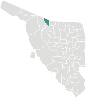
Janos is a municipality in the Mexican state of Chihuahua. It is located in the extreme northwest of Chihuahua, on the border with the state of Sonora and the U.S. states of Arizona & New Mexico. As of 2010, the municipality had a total population of 10,953. The municipal seat is the town of Janos, Chihuahua, which shares its name with the municipality.

The Bridge of the Americas (BOTA) is a group of international bridges which cross the Rio Grande and Texas State Highway Loop 375, connecting the Mexico–United States border cities of Ciudad Juárez, Chihuahua and El Paso, Texas, via the MX 45 from the south and the I-110 from the north, crossing the El Paso BOTA Port of Entry. The bridge is colloquially known as "Puente Libre" in Ciudad Juárez, officially as "Puente Internacional Córdova-Las Américas" or "Puente Internacional Córdova de las Américas", and also known as "Puente Río Bravo", "Cordova Bridge" and "Free Bridge".

The Paso del Norte International Bridge is an international bridge which crosses the Rio Grande connecting the United States-Mexico border cities of El Paso, Texas, and Ciudad Juárez, Chihuahua. The bridge is also known as "Paso del Norte Bridge", "Santa Fe Street Bridge", "Puente Benito Juárez", "Puente Paso del Norte" and "Puente Juárez-Santa Fe". The Paso del Norte International Bridge is a four-lane bridge for northbound non-commercial traffic only. The bridge was constructed in 1967. The American side of the bridge is owned and operated by the City of El Paso.
The Ysleta–Zaragoza International Bridge is an international crossing over the Rio Grande River, connecting the United States-Mexico border cities of El Paso, Texas, and Ciudad Juárez, Chihuahua. The bridge is also known as "Zaragoza Bridge", "Puente Zaragoza" and "Puente Ysleta-Zaragoza".

Chihuahua, officially the Estado Libre y Soberano de Chihuahua (Tepehuán: ?), is one of the 32 states which comprise the 32 Federal Entities of Mexico. It is located in Northwestern Mexico and is bordered by the states of Sonora to the west, Sinaloa to the southwest, Durango to the south, and Coahuila to the east. To the north and northeast, it shares an extensive border with the U.S. adjacent to the U.S. states of New Mexico and Texas. Its capital city is Chihuahua City.

The Municipality of Nogales is a municipality of northern Sonora state, in Northwestern Mexico.
Sáric Municipality is a municipality in Sonora in north-western Mexico. Its northern boundary is the U.S. state of Arizona. The population of the municipality was 2,703 in 2010 living in an area of 1,676.23 square kilometers. The elevation is around 800 meters. At the municipal seat it is 780 meters.

The Alamo Hueco Mountains are a 15-mile (24 km) long mountain range, located in the southeast of the New Mexico Bootheel region, southeast Hidalgo County, New Mexico, adjacent the border of Chihuahua state, Mexico. The range lies near the southern end of the mountains bordering the extensive north-south Playas Valley; the Little Hatchet and Big Hatchet Mountains are adjacent, and mostly attached north; the mountain range series, ends south into the flatland plains of the Chihuahuan Desert. The much smaller Dog Mountains are adjacent south.

New Mexico's Bootheel comprises the southwestern corner of New Mexico. As part of the Gadsden Purchase it is bounded on the east by the Mexican state of Chihuahua along a line at 31°47′0″N108°12′30″W extending south to latitude 31°20′0″N at 31°20′0″N108°12′30″W. The bootheel's southern border is shared between the Mexican States of Chihuahua and Sonora along latitude 31°20′0″N, while the western border with Arizona is along meridian 109°03′0″W at 31°20′0″N109°03′0″W, bounding an area of 50 by 30 miles (48 km) and comprising 1,500 square miles (3,900 km2).
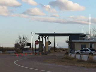
The Antelope Wells Port of Entry is an international border crossing between Antelope Wells, New Mexico, United States, and El Berrendo, Chihuahua, Mexico. It is one of three border crossings into New Mexico, along with the Columbus Port of Entry and the Santa Teresa Port of Entry, and by far the most remote, located in the sparsely populated New Mexico Bootheel. The nearest towns, Janos, Chihuahua and Hachita, New Mexico, are both approximately 45 miles (72 km) away. The crossing is open daily from 10 a.m. to 4 p.m. Mountain Time and is staffed by a single U.S. Customs and Border Protection employee.
New Mexico State Road 81 is a 45.8-mile-long (73.7 km) state road in southwestern New Mexico. The route runs from the Mexico–U.S. border in Antelope Wells north to NM 9 in Hachita, passing through desert and semi-arid farmland. NM 81 is maintained by the New Mexico Department of Transportation (NMDOT).
El Chinal is an town of the Álamos Municipality located in the southeast of the Mexican state of Sonora, close to the boundary with the states of Chihuahua and Sinaloa. It is located 57.2 km southeast of Álamos and 47.8 kilometers Northwest of El Fuerte, in Sinaloa. It lies northwest of Casanate in valley among the hills east of the Rio Cuchujaqui at an elevation of 243 meters.
References
- ↑ 2010 census tables: INEGI Archived May 2, 2013, at the Wayback Machine