Bluefields International Airport is an airport serving Bluefields, a harbor city in the South Caribbean Coast Autonomous Region of Nicaragua. It is the busiest airport in the Caribbean coast of Nicaragua.
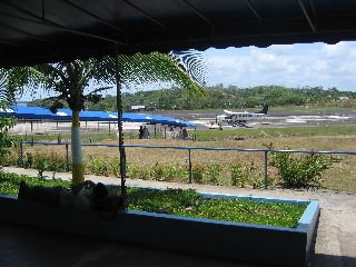
Corn Island International Airport is an airport that serves Great Corn Island on the South Caribbean Coast Autonomous Region. A new terminal has been built and the runway was refurbished so that medium-sized jet aircraft can land the airport. Buses and taxis are both available for transport around the island. It has x-ray machines, two immigration offices.
Bluff is a port city on the Caribbean coast of Nicaragua within the bay of Bluefields. Bluff handles limited cargo and has basic piers. It is also a base for the sea-going fishing vessels on Nicaragua's Caribbean coast.
Jimani Airport was an airstrip serving Jimani, Independencia, Dominican Republic.
Santa Bárbara Airport was an airport formerly serving Santa Bárbara, capital of the Santa Bárbara Department of Honduras.
General Alvear Airport was a public use airport located 8 kilometres (5 mi) south of General Alvear, a city in the Mendoza Province of Argentina.
El Condor Airport was an airstrip 40 kilometres (25 mi) northeast of Yacuíba in the Tarija Department of Bolivia.
El Escondido Airport was an airstrip 25 kilometres (16 mi) southeast of Villamontes, in the Tarija Department of Bolivia.
Rucamelen Airport Spanish: Aeropuerto de Rucamelen, was a rural airstrip 14 kilometres (8.7 mi) east of Bulnes, a town in the Bío Bío Region of Chile.

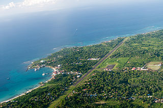
El Jagüel Airport is a general aviation airport serving Maldonado, Uruguay. The airport is in the El Jagüel neighborhood of Punta del Este, 1 mile (1.6 km) east of Maldonado.
Alempue Airport was an airport serving Teno, a city in the Maule Region of Chile.
El Huachi Airport was an airstrip near Santa Bárbara, a town in the Bío Bío Region of Chile.
San Juan de Nicaragua Airport is an airport located in San Juan de Nicaragua, Río San Juan, Nicaragua. The airport was built in 2012 at a cost of almost US$17 million.
El Jadida Airport was an airport serving the city of El Jadida, Morocco.
El Ronco Airport was an airport formerly serving the Holcim, Ltd. El Ronco cement plant 5 kilometres (3.1 mi) west of Metapán in Santa Ana Department, El Salvador.
Karawala Airport is an airstrip serving the village of Karawala in the South Caribbean Coast Autonomous Region of Nicaragua. The airstrip is 6 kilometres (4 mi) inland from the Caribbean coast.
Palcasa Airport is an airport serving the town of El Castillo in Río San Juan Department, Nicaragua. The airport is 5.5 kilometres (3.4 mi) north of El Castillo, midway between the small towns of La Palma and Las Colinas. It is surrounded by and supports the palm oil plantations of Palmares del Castillo S.A. (PALCASA).
Atahualpa Airport was an airport formerly serving the town of Ibarra in Imbabura Province, Ecuador.
Maicao Airport is an airport serving the city of Maicao, in the La Guajira Department of Colombia.
El Dorado Airport is an airstrip serving the river settlement of El Dorado in the La Paz Department of Bolivia. The airport is alongside a tributary stream 1 kilometre (0.62 mi) west of the Beni River.
