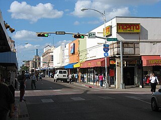
Laredo is a city in the U.S. state of Texas and seat of Webb County, on the north bank of the Rio Grande in South Texas, across from Nuevo Laredo, Tamaulipas, Mexico. Founded in 1755, Laredo grew from a village to the capital of the short-lived Republic of the Rio Grande to the largest inland port on the Mexican border. Laredo's economy is primarily based on international trade with Mexico, and as a major hub for three areas of transportation: land, rail, and air cargo. The city is on the southern end of I-35, which connects manufacturers in northern Mexico through Interstate 35 as a major route for trade throughout the U.S. It has four international bridges and one railway bridge.

Tamaulipas, officially the Free and Sovereign State of Tamaulipas, is a state in Mexico; one of the 31 states which, along with Mexico City, comprise the 32 Federal Entities of Mexico. It is divided into 43 municipalities.

Nuevo Laredo is a city in the Municipality of Nuevo Laredo in the Mexican state of Tamaulipas. The city lies on the banks of the Rio Grande, across from Laredo, United States. The 2010 census population of the city was 373,725. Nuevo Laredo is part of the Laredo-Nuevo Laredo Metropolitan Area with a population of 636,516. The municipality has an area of 1,334.02 km2 (515.07 sq mi). Nuevo Laredo is considered the “customs capital of Latin America” because of its high volume of international trade operations in the region, and number 1 in importance for US inland commercial traffic. Both the city and the municipality rank as the third largest in the state.

Linares is a small city in the state of Nuevo León, Mexico. The city serves as the administrative centre for the surrounding municipality of the same name and it is the largest urban centre of the so-called "orange belt" region. The city had a 2005 census population of 56,065, while the municipality's population was 71,061. The city and the municipality both rank tenth in population in the state. The municipality has an area of 2,445.2 km² and lies in the east-southeast part of the state on the border with the state of Tamaulipas. The municipality of Hualahuises is an enclave of Linares municipality.
Tamaulipas is a state in Northeast Mexico that is divided into 43 municipalities. According to the 2020 Mexican census, it is the fourteenth most populated state with 3,527,735 inhabitants and the sixth largest by land area spanning 80,249.3 square kilometres (30,984.4 sq mi).
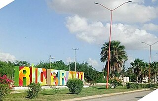
Río Bravo, formally Ciudad Río Bravo, is a city on the northern border of the state of Tamaulipas in northeastern Mexico.

Colombia, Nuevo León is a planned community founded in 1992 by the Mexican state of Nuevo León in the Anáhuac Municipality. It lies on the southern banks of the Río Grande, across from the United States city of Laredo, Texas. According to the INEGI Census, in 2010 Colombia had a population of 514.
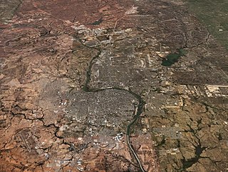
Laredo–Nuevo Laredo is one of six transborder agglomerations along the U.S.-Mexican border. The city of Laredo is situated in the U.S. state of Texas on the northern bank of the Rio Grande and Nuevo Laredo is located in the Mexican State of Tamaulipas in the southern bank of the river. This area is also known as the Two Laredos or the Laredo Borderplex. The area is made up of one county in the U.S and three municipalities in Mexico. Two urban areas, three cities, and 12 towns make the Laredo–Nuevo Laredo Metropolitan area. The two sides of the Borderplex are connected by four International Bridges and an International Railway Bridge. The Laredo–Nuevo Laredo Metropolitan area has a total of 636,516 inhabitants according to the INEGI Census of 2010 and the United States Census estimate of 2010. According to World Gazetteer this urban agglomeration ranked 157th largest in North and South America in 2010 with an estimated population of 675,481. This area ranks 66th in the United States and 23rd in Mexico.

Álvarez, Tamaulipas is a community located in the Nuevo Laredo Municipality in the Mexican state of Tamaulipas. According to the INEGI Census of 2010, Álvarez has a population of 1,714 inhabitants. Its elevation is 141 meters above sea level.
Nuevo Progreso, Tamaulipas also known as El Progreso is a community located in Nuevo Laredo Municipality in the Mexican state of Tamaulipas. According to the INEGI Census of 2010, El Progreso has a population of 432 inhabitants. Its elevation is 150 meters above sea level.
América is a community located in Nuevo Laredo in the Mexican state of Tamaulipas. According to the INEGI Census of 2010, América has a population of 255 inhabitants. Its elevation is 140 meters above sea level.
América is a community located in Nuevo Laredo Municipality in the Mexican state of Tamaulipas. According to the INEGI Census of 2010, América has a population of 197 inhabitants. Its elevation is 135 meters above sea level. It is the second locality of the same name in the municipality, the other is América, which lies just to the west, across Mexican Federal Highway 85.
Los Artistas Segunda Etapa is a community located in Nuevo Laredo Municipality in the Mexican state of Tamaulipas. According to the INEGI Census of 2010, Los Artistas has a population of 54 inhabitants. Its elevation is 164 meters above sea level.
La Cruz is a community located in Nuevo Laredo Municipality in the Mexican state of Tamaulipas. According to the INEGI Census of 2010, La Cruz has a population of 159 inhabitants. Its elevation is 132 meters above sea level.

The Municipality of Nuevo Laredo is located in the Mexican state of Tamaulipas. Its municipal seat is Nuevo Laredo. The municipality contains more than 60 localities which the most important ones are Nuevo Laredo, El Campanario y Oradel, and Álvarez, the last two being suburbs of the city of Nuevo Laredo. By population, the municipality is the third largest in the state of Tamaulipas. The Nuevo Laredo municipality is the northernmost in Tamaulipas, lying at the extreme northwestern tip of its narrow strip of land along the Río Grande. The city of Nuevo Laredo contains approximately 97.5% of the total population of the municipality.

Paseo Reforma is a regional 425,174 sq ft (39,500.0 m2) indoor mall located in Nuevo Laredo, Tamaulipas, Mexico south in the city's retail district. The shopping mall was built from 2007-2008 and was opened in May 2008 at a cost to developer Latin American Realty of $90 million. It was the first mall of its kind in Nuevo Laredo. The mall has three major anchors and has sub-anchors such as Famsa. The mall is situated in a lot with a total area of 1,356,468 ft² which includes 2,000 parking spaces and 6 pads for restaurants outside the mall.
Morelos also known as El Estero is a community located in Nuevo Laredo Municipality in the Mexican state of Tamaulipas. According to the INEGI Census of 2010, Morelos has a population of 96 inhabitants, 54 males and 42 females. Its elevation is 164 meters above sea level.
La Esperanza is a community located in Nuevo Laredo Municipality in the Mexican state of Tamaulipas. According to the INEGI Census of 2010, La Esperanza has a population of 69 inhabitants, 39 males and 30 females. Its elevation is 164 meters above sea level.
Pueblo Nuevo is a census-designated place (CDP) in Webb County, Texas, United States.This was a new CDP formed from parts of the Laredo Ranchettes CDP and additional area prior to the 2010 census, with a population of 521.

Oradel Industrial Center is located in the city of Nuevo Laredo, Tamaulipas, Mexico. It is an industrial zone funded in 2000 and located on the route that connects the East Zone of the United States with Mexico.


