El Carmen District, Chincha

Last updated
El Carmen
District

Recolte du coton a El Carmen - Perou 10.JPG

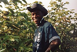
A person collecting cotton at El Carmen
Country Flag of Peru.svg  Peru
Region Ica
Province Chincha
Founded August 28, 1916
Capital El Carmen
Government
   Mayor José Alberto Soria Calderon
Area
  Total 790.82 km2 (305.34 sq mi)
Elevation 155 m (509 ft)
Population (2012 census)
  Total 12,777
  Density 16/km2 (42/sq mi)
Time zone PET (UTC-5)
UBIGEO 110205
Website www.munielcarmen.gob.pe/

El Carmen District is one of eleven districts of the province Chincha in Peru. [1]

Districts of Peru third level administrative subdivision of Peru

The districts of Peru are the third-level country subdivisions of Peru. They are subdivisions of the provinces, which in turn are subdivisions of the larger regions or departments. There are 1,838 districts in total.

Chincha Province Province in Ica, Peru

The Chincha Province is one of five provinces of the Ica Region of Peru. The capital of the province is the city of Chincha Alta.

Peru republic in South America

Peru, officially the Republic of Peru, is a country in western South America. It is bordered in the north by Ecuador and Colombia, in the east by Brazil, in the southeast by Bolivia, in the south by Chile, and in the west by the Pacific Ocean. Peru is a megadiverse country with habitats ranging from the arid plains of the Pacific coastal region in the west to the peaks of the Andes mountains vertically extending from the north to the southeast of the country to the tropical Amazon Basin rainforest in the east with the Amazon river.

Contents

See also

Related Research Articles

Cerro Azul District is one of sixteen districts of the province Cañete in Peru.

Aczo District is one of six districts of the province Antonio Raymondi in Peru.

Carmen Alto District is one of fifteen districts of the province Huamanga in Peru.

Imperial District District in Lima, Peru

Imperial District is one of sixteen districts of the province Cañete in Peru.

Nuevo Imperial District is one of sixteen districts of the province Cañete in Peru.

San Luis District is one of sixteen districts of the province Cañete in Peru.

San Vicente de Cañete District is one of sixteen districts of Cañete Province in Peru.

Ondores District is one of four districts of the province Junín in Peru.

Sangallaya District is one of thirty-two districts of the province Huarochirí in Peru.

Santiago de Anchucaya District is one of thirty-two districts of the province Huarochirí in Peru.

Santo Domingo de los Olleros District is one of thirty-two districts of the province Huarochirí in Peru.

Quinocay District District in Lima, Peru

Quinocay District is one of thirty-three districts of the province Yauyos in Peru.

San Pedro de Pilas District District in Lima, Peru

San Pedro de Pilas District is one of thirty-three districts of the province Yauyos in Peru.

Arahuay District is one of seven districts of the province Canta in Peru.

Paucartambo District, Paucartambo District in Cusco, Peru

Paucartambo is one of six districts of the Paucartambo Province in Peru.

Conchamarca District is one of eight districts of the province Ambo in Peru.

El Carmen District is one of ten districts of the province Churcampa, in Peru.

Cahuac District is one of eight districts of the province Yarowilca in Peru.

Anra District is one of sixteen districts of the province Huari in Peru.

References

Coordinates: 13°29′59″S76°03′27″W / 13.4998°S 76.0575°W / -13.4998; -76.0575

Geographic coordinate system Coordinate system

A geographic coordinate system is a coordinate system that enables every location on Earth to be specified by a set of numbers, letters or symbols. The coordinates are often chosen such that one of the numbers represents a vertical position and two or three of the numbers represent a horizontal position; alternatively, a geographic position may be expressed in a combined three-dimensional Cartesian vector. A common choice of coordinates is latitude, longitude and elevation. To specify a location on a plane requires a map projection.