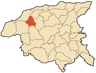
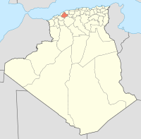
El Hassi | |
---|---|
Commune and town | |
Country | |
Province | Relizane Province |
Time zone | UTC+1 (CET) |
El Hassi is a town and commune in Relizane Province, Algeria. [1]
The municipalities of Algeria form the second level of administrative subdivisions of Algeria. As of 2002, there were 1,541 municipalities in the country.
Relizane is a province (wilaya) of Algeria. Relizane is the capital. Other localities include Bendaoud, Bouzegza, Hamri, Kalaa, Mazouna and Zemmoura.
Algeria, officially the People's Democratic Republic of Algeria, is a country in the Maghreb region of North Africa. The capital and most populous city is Algiers, located in the far north of the country on the Mediterranean coast. With an area of 2,381,741 square kilometres (919,595 sq mi), Algeria is the tenth-largest country in the world, the world's largest Arab country, and the largest in Africa. Algeria is bordered to the northeast by Tunisia, to the east by Libya, to the west by Morocco, to the southwest by the Western Saharan territory, Mauritania, and Mali, to the southeast by Niger, and to the north by the Mediterranean Sea. The country is a semi-presidential republic consisting of 48 provinces and 1,541 communes (counties). It has the highest human development index of all the non-island African countries.
The Giona is a ‘torrent’, or intermittent stream, which rises on the slopes of Monte Tamaro, in the Swiss canton of Ticino. After about 2 kilometres (1.2 mi), it enters the Italian province of Varese, forming the Val Veddasca before entering Lake Maggiore at Maccagno. Its course passes through the communes of Indemini in Switzerland and Veddasca, Curiglia con Monteviasco, Dumenza and Maccagno in Italy.
Saoula is a suburb of the city of Algiers in northern Algeria. It is one of the five municipalities in the Bin Mourad Rais district.
Vinanitelo is a town and commune in Madagascar. It belongs to the district of Manakara, which is a part of Vatovavy-Fitovinany Region. The population of the commune was estimated to be approximately 10,000 in 2001 commune census.
Șiștarovăț is a commune in Arad County, Romania, is situated on the Lipovei Hills and it occupies approximately 12,300 ha. It is composed of four villages: Cuveșdia (Temeskövesd), Labașinț (Lábas), Șiștarovăț and Varnița (Mészdorgos).
Azzaba is a town and commune in Azzaba District, Skikda Province, Algeria.
Chebli is a town and commune in Blida Province, Algeria. According to the 1998 census it has a population of 21,506.
Tidjelabine is a town and commune in Boumerdès Province, Algeria. According to the 1998 census it has a population of 13,888.
Moussadek is a town and commune in Chlef Province, Algeria. According to the 1998 census it has a population of 5,496.
Bouhmama is a town and commune in Khenchela Province, Algeria. According to the 1998 census it has a population of 9,669.
Benzouh is a town and commune in M'Sila Province, Algeria. According to the 1998 census it has a population of 4,197.
Benyahia Abderrahmane is a town and commune in Mila Province, Algeria. At the 1998 census it had a population of 10,222.
Aïn Boudinar is a town and commune in Mostaganem Province, Algeria. It is located in Kheïr Eddine District. According to the 1998 census it has a population of 5,241.
El Matmar is a town and commune in Relizane Province, Algeria.
Moulay Larbi is a town and commune in Saïda Province in northwestern Algeria.
Ouled Driss is a town and commune in Souk Ahras Province in north-eastern Algeria.
Morsott is a town and commune in Tébessa Province in north-eastern Algeria.
Oum Ali is a town and commune in Tébessa Province in north-eastern Algeria.
Rahouia is a town and commune in Tiaret Province in north-western Algeria.
Bouhlou is a town and commune in Tlemcen Province in northwestern Algeria.
Yakouren is a town and commune in Tizi Ouzou Province in northern Algeria.
Coordinates: 35°44′N1°01′E / 35.733°N 1.017°E
A geographic coordinate system is a coordinate system that enables every location on Earth to be specified by a set of numbers, letters or symbols. The coordinates are often chosen such that one of the numbers represents a vertical position and two or three of the numbers represent a horizontal position; alternatively, a geographic position may be expressed in a combined three-dimensional Cartesian vector. A common choice of coordinates is latitude, longitude and elevation. To specify a location on a plane requires a map projection.
This article about a location in Relizane Province is a stub. You can help Wikipedia by expanding it. |