As the tenth-largest country in the world, and the largest in Africa and in the Mediterranean region, Algeria has a vast transportation system that includes a large and diverse transportation infrastructure.
Articles related to Algeria include:

Algeria, as of 2024, is divided into 58 wilayas (provinces). Prior to December 18, 2019, there were 48 provinces. The 58 provinces are divided into 1,541 baladiyahs (municipalities). The name of a province is always that of its capital city.

Boumerdès is a province (wilaya) of northern Algeria, located in the Kabylia region, between Algiers and Tizi-Ouzou, with its capital at the coastal city of Boumerdès just east of Algiers.

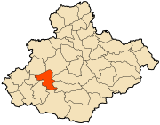
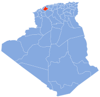
Relizane is a province (wilaya) of Algeria. Relizane is the capital. Other localities include Bendaoud, Bouzegza, Hamri, Kalaa, Mazouna and Zemmoura. The Wilaya of Relizane massacres of 4 January 1998 happened in Relizane.
Adrar is the administrative capital of Adrar Province, the second largest province in Algeria. The commune is sited around an oasis in the Touat region of the Sahara Desert. According to a 2008 census, it has a population of 64,781, up from 43,903 in 1998, with an annual growth rate of 4.0%.
Bordj Badji Mokhtar is a town and commune in Bordj Badji Mokhtar District, Bordj Badji Mokhtar Province, in south-western Algeria. According to the 2008 census it has a population of 16,437, up from 9,323 in 1998, with an annual growth rate of 6.0%, the highest in the province. It was named after the Algerian independence activist Badji Mokhtar (1919–1954). The inhabitants are mainly Tuaregs.

Algiers Province is a province (wilayah) in Algeria, named after its capital, Algiers, which is also the national capital. It is adopted from the old French department of Algiers and has a population of about 8 million. It is the most densely populated province of Algeria, and also the smallest by area.

Bordj Omar Driss is a town and commune in In Amenas District, Illizi Province, Algeria. According to the 2008 census it has a population of 5,736, up from 3,547 in 1998, and an annual population growth rate of 5.0%. Its postal code is 33210 and its municipal code is 3304.

The National Rail Transportation Company is Algeria's national railway operator. The SNTF, a state-owned company, currently has a monopoly over Algeria's rail network of 3,973 km (2,469 mi), although it is currently utilising only 3,572 km (2,220 mi). Out of the total railway network, 2,888 km (1,795 mi) are 1,435 mmstandard gauge and 1,085 km (674 mi) are 1,055 mm narrow gauge.
Timiaouine is a town and commune in Bordj Badji Mokhtar District, Bordj Baji Mokhtar Province, in southwest Algeria near the border with Mali. According to the 2008 census it has a population of 4,493, up from 4,206 in 1998, with an annual growth rate of 0.7%, the lowest rate in the province.

Ain Tarik is a municipality occupying 178 km2 located southeast of Relizane Province, Algeria. It is the district seat of Ain Tarik District. In 2002, its population was 12,287.
Rapide Club de Relizane , known as RC Relizane or simply RCR for short, is a football club based in the city of Relizane. The club was founded in 1934 and its colours are white and green. Their home stadium, Tahar Zoughari Stadium, has a capacity of some 30,000 spectators. The club is currently playing in the Inter-Régions Division.

The 2016–17 Algerian Cup was the 53rd edition of the Algerian Cup. The eventual winners were CR Belouizdad who qualified for the 2018 CAF Confederation Cup.
Mohamed Seghir Boushaki, was an Algerian Kabyle politician after the French conquest of Algeria.
In the 2020–21 season, RC Relizane is competing in the Ligue 1 for the 8th season, and League Cup.
The Battle of Alma or Battle of Boudouaou, which broke out on 19 April 1871, was a battle of the Mokrani Revolt by Algerian rebels against France, which had been the colonial power in the region since 1830.

Algerian Broadcasting Company is an undertaking for the broadcasting of radio and television services in Algeria. TDA is a so-called public industrial and commercial company (EPIC), which means that it is an independent legal entity that manages a public service. TDA also offers internet, technical and satellite services. Algeria's Ministry of Communications is the supervisory authority for the TDA.

The history of rail transport in Algeria began in 1857 during the French colonization with the implementation of an initial plan for the creation of a 1,357 kilometres (843 mi) railway network. This plan, formalized by a decree from Emperor Napoleon III, defined the initial framework of the Algerian railway network, which continued to evolve throughout the second half of the 19th century, both in terms of its scale and structure.