El Kantara District | |
|---|---|
 | |
| Country | |
| Province | Biskra Province |
| Time zone | UTC+1 (CET) |
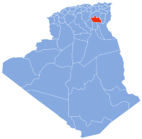
El Kantara District is a district of Biskra Province, Algeria.
| This article about a location in Biskra Province is a stub. You can help Wikipedia by expanding it. |
El Kantara District | |
|---|---|
| | |
| Country | |
| Province | Biskra Province |
| Time zone | UTC+1 (CET) |
El Kantara District is a district of Biskra Province, Algeria.
| This article about a location in Biskra Province is a stub. You can help Wikipedia by expanding it. |

The House of Councillors is the upper house of the National Diet of Japan. The House of Representatives is the lower house. The House of Councillors is the successor to the pre-war House of Peers. If the two houses disagree on matters of the budget, treaties, or designation of the prime minister, the House of Representatives can insist on its decision. In other decisions, the House of Representatives can override a vote of the House of Councillors only by a two-thirds majority of members present.

Kanzaki is a district located in Hyōgo Prefecture, Japan.

Haifa District is an administrative district surrounding the city of Haifa, Israel. The district is one of seven administrative districts of Israel, and its capital is Haifa. The district land area is 864 km2 (299.3 mi2).
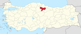
Amasya Province is a province of Turkey, situated on the Yeşil River in the Black Sea Region to the north of the country.
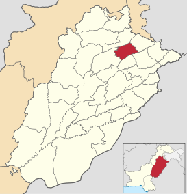
Mandi Bahauddin, also spelled Mandi Baha ud Din, is a district in the Punjab province of Pakistan. It is bordered on the northwest by the Jhelum River, on the southeast by the Chenab River, and on the southwest by the Sargodha District. The district has an area of 2,673 square kilometres (1,032 sq mi). Mandi district currently has 1.5 million population.

Pashtun Kot district is located in the center of Faryab Province, south of the provincial capital Maymana. The district center Pashtun Kot is a suburb of Maymana. The population is 277,000 (2002) with an ethnic composition of 60% Pashtun, 5% Tajik and 20% Uzbek 10 Turkmen and minority Arab Aimaq.

The Edo River is a river in the Kantō region of Japan. It splits from the Tone River at the northernmost tip of Noda City in the Sekiyado district, crosses through Nagareyama and Matsudo, and empties into Tokyo Bay at Ichikawa, Chiba Prefecture. The Edo forms the borders between Tokyo, Chiba, and Saitama prefectures. The Edo River is 59.5 kilometres (37.0 mi) long.

Barika District is a district of Batna Province, Algeria.

Djezzar District is a district of Batna Province, Algeria.

Merouana District is a district of Batna Province, Algeria.

N'Gaous District is a daïra in the Batna wilaya of Algeria, whose administrative center is the commune of the same name.

Ouled Si Slimane District is a district of Batna Province, Algeria.

Seggana District is a district of Batna Province, Algeria.
Amiret Touazra is a town and commune in the Monastir Governorate, Tunisia. It has 6,261 inhabitants in 2014.

Salah Bey District is a district of Sétif Province, Algeria.
The Acre Subdistrict was one of the subdistricts of Mandatory Palestine. It was located in modern-day northern Israel, having nearly the same territory as the modern-day Acre County. The city of Acre was the district's capital.
Pareh is a village in Susan-e Gharbi Rural District, Susan District, Izeh County, Khuzestan Province, Iran. At the 2006 census, its population was 42, in 5 families.
Dashtab Rural District is a rural district (dehestan) in the Central District of Baft County, Kerman Province, Iran. At the 2006 census, its population was 5,170, in 1,144 families. The rural district has 49 villages.
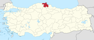
Sinop Province is a province of Turkey, along the Black Sea. It is located between 41 and 42 degrees North latitude and between 34 and 35 degrees East longitude. The surface area is 5,862 km2, equivalent to 0.8% of Turkey's surface area. The borders total 475 km and consists of 300 km of land and 175 km seaside borders. Its adjacent provinces are Kastamonu on the west, Çorum on the south, and Samsun on the southeast. The provincial capital is the city of Sinop.
Augusta was a town in the interior of ancient Cilicia, inhabited during Roman and Byzantine times. The name shows that it was either founded under the patronage of some Roman emperor, or a new Roman name was given to an old place. Ptolemy places this town in a district named Bryelice. The town also bore the name Augustopolis, and possibly Thebae.