
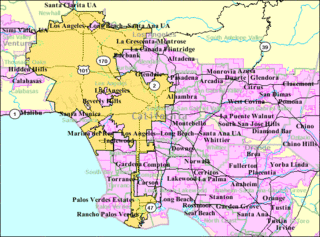
The South Bay is a region of the Los Angeles metropolitan area, located in the southwest corner of Los Angeles County. The name stems from its geographic location stretching along the southern shore of Santa Monica Bay. The South Bay contains fifteen cities plus portions of the City of Los Angeles and unincorporated portions of the county. The area is bounded by the Pacific Ocean on the south and west and generally by the City of Los Angeles on the north and east.

Hermosa Beach is a beachfront city in Los Angeles County, California, United States. Its population was 19,506 at the 2010 U.S. Census. The city is located in the South Bay region of the Greater Los Angeles area; it is one of the three Beach Cities. Hermosa Beach is bordered by the other two, Manhattan Beach to the north and Redondo Beach to the south and east.

Manhattan Beach is a city in southwestern Los Angeles County, California, United States, on the Pacific coast south of El Segundo, and north of Hermosa Beach. As of the 2010 census, the population was 35,135, and in 2018 the population was estimated to be 35,532.
The Los Angeles metropolitan area, also known as Metropolitan Los Angeles or the Southland, is the 30th largest metropolitan area in the world and the second-largest metropolitan area in the United States. It is the 3rd largest city by GDP in the world with a $1 trillion+ economy. It is entirely in the southern portion of the U.S. state of California.

Santa Monica Bay is a bight of the Pacific Ocean in Southern California, United States. Its boundaries are slightly ambiguous, but it is generally considered to be the part of the Pacific within an imaginary line drawn between Point Dume, in Malibu, and the Palos Verdes Peninsula. Its eastern shore forms the western boundary of the Los Angeles Westside and South Bay regions. Although it was fed by the Los Angeles River prior to the river's catastrophic change of course in 1825, the only stream of any size now flowing into it is Ballona Creek. Other waterways draining into the bay include Malibu Creek, Topanga Creek, and Santa Monica Creek.
El Camino College is a two-year public community college located in the unincorporated area of Los Angeles County known as Alondra Park. It consists of 37 buildings spanning an area of roughly 26 acres (11 ha). It is one of two community colleges serving Southern California's South Bay area.

El Porto is a beach community that is part of Manhattan Beach, a city in the South Bay area of Greater Los Angeles in Southern California.

Marina State Beach is a protected beach on Monterey Bay, located in the city of Marina in Monterey County, California.

California's 33rd congressional district is a congressional district in the U.S. state of California based in Los Angeles County. The district is currently represented by Democrat Ted Lieu. In 2014, after 40 years in Congress, previous representative Henry Waxman announced his retirement.

The North Coast of California is the region in Northern California that lies on the Pacific coast between San Francisco Bay and the Oregon border. It commonly includes Mendocino, Humboldt, and Del Norte counties and sometimes includes two counties from the San Francisco Bay area, Marin and Sonoma.
The Long Beach Public Library (LBPL) is an American public library system located in Long Beach, California.

Founded in 1915, the Los Angeles Area Council (LAAC) (#033) served most of the City of Los Angeles as well as several other cities in the greater Los Angeles area. It was one of five Boy Scouts of America councils in Los Angeles County, California. Since its founding in 1915, the Los Angeles Area Council has brought its purpose and values to millions of youth. The Council served 54,567 youth in the Greater Los Angeles Area in 2008 alone.
Alamitos Heights is a neighborhood in the south-east portion of the city of Long Beach, California, United States.
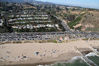
The Manhattan Beach Pier is a pier located in Manhattan Beach, California, on the coast of the Pacific Ocean. The pier is 928 feet (283 m) long and located at the end of Manhattan Beach Boulevard. An octagonal Mediterranean-style building sits at the end of the pier and houses the Roundhouse Marine Studies Lab & Aquarium. Surfers usually can be seen below the pier. The pier includes the "Volleyball Walk of Fame," featuring plaques dedicated to past winners of the Manhattan Beach Open beach volleyball tournament. The pier is popular with locals, tourists, photographers, and artists and for fishing. It offers sunsets and vantage points from the shore and hillside.
Will Rogers State Beach is a beach park on the Santa Monica Bay, at the Pacific coast of Southern California. Located in Pacific Palisades, the beach is owned by the California Department of Parks and Recreation; however, it is managed and maintained by the Los Angeles County Department of Beaches and Harbors. A section just south of the intersection of Pacific Coast Highway and Entrada Drive is popular within the LGBT community and is therefore considered Los Angeles' unofficial gay beach; this section is often referred to as Ginger Rogers Beach.

Rosecrans Avenue is a major west-east thoroughfare in Los Angeles and Orange Counties, California, USA. It has a total length of 27.5 miles (44.3 km). The street is named after U.S. Union General William S. Rosecrans, who purchased 13,000 acres of Rancho Sausal Redondo southwest of Los Angeles in 1869. Rosecrans Avenue was originally named Drexel Avenue, and ran through the Rosecrans Rancho which is part of modern-day Gardena.

Robert H. Meyer Memorial State Beach is a state beach of California, located in northern Malibu, Southern California.
The park is part of the Santa Monica Mountains National Recreation Area.
Bruce's Beach was a small beach resort in the city of Manhattan Beach, California, that was owned by and operated for African Americans. It provided the African American community with opportunities unavailable at other beach areas because of segregation.
Maywood Assembly was a Ford Motor Company assembly plant located in City of Commerce, southwestern Los Angeles County, California.
