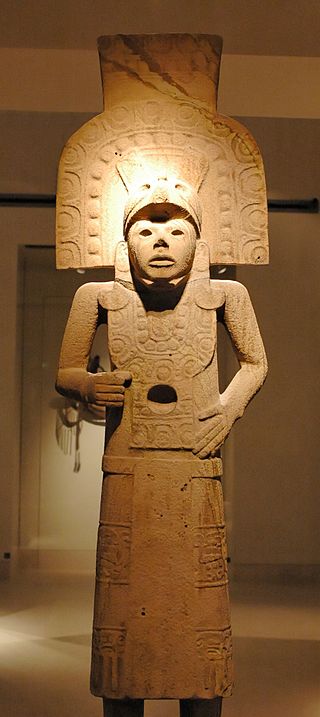
The Huastec or Téenek are an indigenous people of Mexico, living in the La Huasteca region including the states of Hidalgo, Veracruz, San Luis Potosí and Tamaulipas concentrated along the route of the Pánuco River and along the coast of the Gulf of Mexico.

Tepoztlán is a town in the central Mexican state of Morelos. It is located at 18°59′07″N99°05′59″W in the heart of the Tepoztlán Valley. The town serves as the seat of government for the municipality of the same name. The town had a population of 14,130 inhabitants, while the municipality reported 41,629 inhabitants in the 2010 national census.

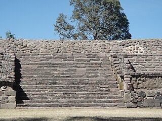
Mesoamerican pyramids form a prominent part of ancient Mesoamerican architecture. Although similar in some ways to Egyptian pyramids, these New World structures have flat tops and stairs ascending their faces. The largest pyramid in the world by volume is the Great Pyramid of Cholula, in the east-central Mexican state of Puebla. The builders of certain classic Mesoamerican pyramids have decorated them copiously with stories about the Hero Twins, the feathered serpent Quetzalcoatl, Mesoamerican creation myths, ritualistic sacrifice, etc. written in the form of Maya script on the rises of the steps of the pyramids, on the walls, and on the sculptures contained within.

La Quemada is an archeological site. It is located in the Villanueva Municipality, in the state of Zacatecas, about 56 km south of the city of Zacatecas on Fed 54 Zacatecas–Guadalajara, in Mexico.

La Huasteca is a geographical and cultural region located partially along the Gulf of Mexico and including parts of the states of Tamaulipas, Veracruz, Puebla, Hidalgo, San Luis Potosí, Querétaro and Guanajuato. It is roughly defined as the area in which the Huastec people had influence when their civilization was at its height during the Mesoamerican period. Today, the Huastecs occupy only a fraction of this region with the Nahua people now the most numerous indigenous group. However, those who live in the region share a number of cultural traits such as a style of music and dance, along with religious festivals such as Xantolo.

The Huastec civilization was a pre-Columbian civilization of Mesoamerica, occupying a territory on the Gulf coast of Mexico that included the northern portion of Veracruz state, and neighbouring regions of the states of Hidalgo, Querétaro, San Luis Potosí, and Tamaulipas. The Huastec people were an early offshoot of the Maya peoples that migrated northwards.

The pre-Columbian history of the territory now making up the country of Mexico is known through the work of archaeologists and epigraphers, and through the accounts of Spanish conquistadores, settlers and clergymen as well as the indigenous chroniclers of the immediate post-conquest period.
Castillo de Teayo is a mesoamerican Prehispanic archeological site and Mesoamerican pyramid, located in the La Huasteca region in northern Veracruz, Mexico. The main access to the site is via Federal Highway 130 México-Tuxpan up to the city of Teayo, it belongs to the Huastec culture and it is estimated it was inhabited between the 10th and 12th centuries.
El Cóporo is a prehispanic archaeological site at the northern frontiers of the Mesoamerican cultural area, located at an elevation of 150 meters on the western slopes of the Santa Bárbara range, near the San José del Torreón community, and lies some 15 kilometres (9 mi) due south of its municipal seat and largest township, on the northwestern corner of Guanajuato state, Mexico.
Balcón de Montezuma, also known as "Balcon del Chiue" is an archaeological site located at the Alta Cumbre ejido, some 18 kilometres (11.2 mi) south of Ciudad Victoria, in the state of Tamaulipas, México. It is situated about one kilometer north of Highway 101, towards San Luis Potosí.

Altavista, or Chalchihuites, is an archaeological site near the municipality of Chalchihuites in the Mexican state of Zacatecas, in the northwest of Mexico. It is believed that the site was a cultural oasis that was occupied more or less continuously from AD 100 to AD 1400.

El Chanal is an archaeological site located at El Chanal town, 4 kilometres (2.5 mi) north of the city of Colima, Mexico. Based on its extension, over 50 hectares, it is probable that it was the largest settlement of the state of Colima; it developed on both banks of the “Río Verde” or Río Colima. This archeological zone is maintained by the people of El Chanal. The area may have been inhabited by native groups around 1300 BC, achieving its maximum splendor between 1100 and 1400 CE. There is a Nahuatl connection shown by archaeological materials representing deities such as Tláloc and Ehécatl.
El Conde is an archeological site located at Ozumba Street, El Conde, three block north the Mayo 1 Ave., in the municipality of Naucalpan, Mexico State.
Huapalcalco is a pre-Columbian Mesoamerican archeological site located some 5 kilometers north of Tulancingo in the state of Hidalgo, Mexico.

Ixtlán del Rio is an archaeological site located in the Ixtlán del Rio municipality, on the south west region of the Mexican state of Nayarit. It is also known as "Los Toriles" and contains the only vestiges of the western cultures in Nayarit.
Mesa de Cacahuatenco is a Mesoamerican pre-Columbian archeological site, located in the municipality of Ixhuatlán de Madero in northern Veracruz, Mexico, south of the Vinasca River.
Las Flores is an archaeological site pertaining to the Huastec civilization in the city of Tampico, Tamaulipas, in Mexico.
The Sierra de Tamaulipas is an isolated, semi-tropical mountain range in the Mexican state of Tamaulipas. Its highest point is 1,260 m (4,130 ft). There are no cities or towns in the Sierra and the small population is largely agricultural. The higher elevations of the Sierra have forests of oak and pine, contrasting with the semi-arid brush that dominates at lower altitudes. Several archaeological sites establish that the Sierra de Tamaulipas was the northern outpost of the agricultural Mesoamerican peoples of eastern Mexico.
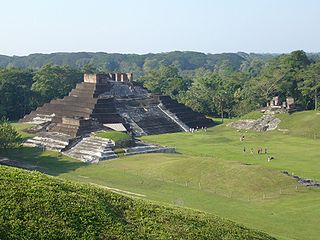
Comalcalco is an ancient Maya archaeological site in the State of Tabasco, Mexico, adjacent to the modern city of Comalcalco and near the southern coast of the Gulf of Mexico. It is the only major Maya city built with bricks rather than limestone masonry and was the westernmost city of the Maya civilisation. Covering an area of 7 km2 (2.7 sq mi), Comalcalco was founded in the Late Classic period and may have been a satellite or colony of Palenque based on architectural similarities between the two. The city was a center of the Chontal Maya people.
Tammapul is a Pre-Columbian ruin in Tamaulipas, Mexico attributed to the Huastec civilization. It is located 8 kilometers southeast of the city of Tula, and sits by the shores of the Tula lagoon. Tammapul is believed to be a Huastec settlement, but 35,000 ceramic remains found on-site suggest a simultaneous connection to the Río Verde culture from the neighboring San Luis Potosí.

