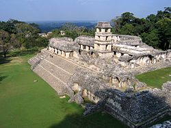
Overview of the central plaza of the Maya city of Palenque (Chiapas, Mexico), an example of Classic period Mesoamerican architecture
Mesoamerican architecture is the set of architectural traditions produced by pre-Columbian cultures and civilizations of Mesoamerica, traditions which are best known in the form of public, ceremonial and urban monumental buildings and structures. The distinctive features of Mesoamerican architecture encompass a number of different regional and historical styles, which however are significantly interrelated. These styles developed throughout the different phases of Mesoamerican history as a result of the intensive cultural exchange between the different cultures of the Mesoamerican culture area through thousands of years. Mesoamerican architecture is mostly noted for its pyramids, which are the largest such structures outside of Ancient Egypt.
One interesting and widely researched topic is the relation between cosmovision, religion, geography, and architecture in Mesoamerica. Much seems to suggest that many traits of Mesoamerican architecture were governed by religious and mythological ideas. For example, the layout of most Mesoamerican cities seem to be influenced by the cardinal directions and their mythological and symbolic meanings in Mesoamerican culture.
Another part of Mesoamerican architecture is its iconography. The monumental architecture of Mesoamerica was decorated with images of religious and cultural significance, and also in many cases with writing in some of the Mesoamerican writing systems. Iconographic decorations and texts on buildings are important contributors to the overall current knowledge of pre-Columbian Mesoamerican society, history and religion.
The Palace in PalenqueGovernor's Palace, UxmalTikalChichen Itza, Great Ball Court, Temple of the Jaguars
The following tables show the different phases of Mesoamerican architecture and archeology and correlates them with the cultures, cities, styles and specific buildings that are notable from each period.
The layout of the city of Teotihuacan. The central part of the city is laid out following a north/south axis aligned about 15.5 degrees off, and which is marked by the "Street of the dead". The pyramid of the sun is in the center, built on an artificial cave. The southern part is skewed about 16.5 degrees east of north, following the orientation of the Ciudadela, mostly surrounded by residential quarters, while the northern part is the ceremonial center used for among other things human sacrifice.
An important part of the Mesoamerican religious system was replicating their beliefs in concrete tangible forms, in effect making the world an embodiment of their beliefs.[1] This meant that the Mesoamerican city was constructed to be a microcosm, manifesting the same division that existed in the religious, mythical geography—a division between the underworld and the human world. The underworld was represented by the direction north and many structures and buildings related to the underworld, such as tombs, are often found in the city's northern half. The southern part represented life, sustenance, and rebirth and often contained structures related to the continuity and daily function of the city-state, such as monuments depicting the noble lineages, or residential quarters, markets, etc. Between the two halves of the north/south axis was the plaza, often containing stelae resembling the world tree the Mesoamerican axis mundi, and a ballcourt which served as a crossing point between the two worlds.
Some Mesoamericanists argue that in religious symbolism the Mesoamerican monumental architecture pyramids were mountains, stelae were trees, and wells, ballcourts and cenotes were caves that provided access to the underworld.[2]
Orientation
Mesoamerican architecture is often designed to align to specific celestial events. Some pyramids, temples, and other structures were designed to achieve special lighting effects on particular days important in the Mesoamerican cosmovision. A famous example is the "El Castillo" pyramid at Chichen Itza, where a light-and-shadow effect can be observed during several weeks around the equinoxes. Contrary to a common opinion, however, there is no evidence that this phenomenon was the result of a purposeful design intended to commemorate the equinoxes.[3]
Much Mesoamerican architecture is also aligned to roughly 15° east of north.[4] Vincent H Malmstrom has argued[5] that this is because of a general wish to align the pyramids to face the sunset on August 13, which was the beginning date of the Maya Long Count calendar. However, recent research has shown that the earliest orientations marking sunsets on August 13 (and April 30) occur outside of the Maya area. Their purpose must have been to record the dates separated by a period of 260 days (from August 13 to April 30), equivalent to the length of the sacred Mesoamerican calendrical count. In general, the orientations in Mesoamerican architecture tend to mark the dates separated by multiples of 13 and 20 days, i.e. of basic periods of the calendrical system. The distribution of these dates in the year suggests that the orientations allowed the use of observational calendars that facilitated the prediction of agriculturally significant dates.[6][7] These conclusions are supported by the results of systematic research accomplished in various Mesoamerican regions, including central Mexico,[8] the Maya Lowlands,[9][10] Oaxaca, the Gulf Coast lowlands,[11] and western and northern Mesoamerica.[12] While solar orientations prevail, some prominent buildings were aligned to Venus extremes,[13] a notable example being the Governor's Palace at Uxmal.[14] Orientations to lunar standstill positions on the horizon have also been documented;[15] they are particularly common along the Northeast Coast of the Yucatán peninsula, where the worship of the goddess Ixchel, associated with the Moon, is known to have had an outstanding importance during the Postclassic period.[16]
Nearly every known ancient Mesoamerican city had one or more formal public plazas. They are typically large impressive spaces, surrounded by tall pyramids, temples, and other important buildings. Activities that would take place in these plazas would include private rituals, periodic markets, mass spectator ceremonies, participatory public ceremonies, feasts, and other popular celebrations.
The size of the main plazas in Mesoamerican cities differed greatly, the largest being located in Tenochtitlan with an estimated size of 115,000 square meters. This plaza is an outlier due to the population of the city being so large. The next largest estimated plaza is located in the Gulf Coast in the city of Cempoala (or Zempoala), measuring at 48,088 square meters.[17] Most plazas average at around 3,000 square meters, the smallest being at the site of Paxte which is 528 square meters. Some cities contain many smaller plazas throughout, while some focus their attention on a significantly large main plaza.
Reconstructed scale model of the Great Temple of Tenochtitlan
Tenochtitlan was an Aztec city that thrived from 1325 to 1521. The city was built on an island, surrounded on all sides by Lake Texcoco. It consisted of an elaborate system of canals, aqueducts, and causeways allowing the city to supply its residents. The island was about 12 square kilometers and had a population of approximately 125,000 people, making it the largest Mesoamerican city ever recorded. The main plaza of Tenochtitlan was approximately 115,000 square meters, or 11.5ha (28 acres).[18] The main temple of Tenochtitlan known as Templo Mayor or the Great Temple was 100 meters by 80 meters at its base, and 60 meters tall.[19] The city ultimately fell in 1521 when it was destroyed by the Spanish conquistador Hernán Cortés in 1521. Cortés and the Spaniards raided the city for its gold supply and artifacts, leaving little behind of the Aztec's civilization.
At the monumental Templo Mayor of Tenochtitlan, archaeologists discovered that the Aztec enlarged the temple seven times, with five extra façades, but always kept intact the basic dual symbolism of the rain god Tlaloc and the tribute/war god Huitzilopochtli. Mexican Archaeologist Eduardo Matos Moctezuma has shown that the symbolic and ritual life of this imperial shrine unified the patterns of forced tributary payments from hundreds of communities with the agricultural and hydraulic subsystems of food production.[20]
Often the most important religious temples sat atop the towering pyramids, presumably as the closest place to the heavens. While recent discoveries point toward the extensive use of pyramids as tombs, the temples themselves seem to rarely, if ever, contain burials. Residing atop the pyramids, some of over two-hundred feet, such as that at El Mirador, the temples were impressive and decorated structures themselves. Commonly topped with a roof comb, or superficial grandiose wall, these temples might have served as a type of propaganda.
The Pyramid of the Sun is the largest structure created in the city of Teotihuacan and one of the largest structures in the entire Western Hemisphere. It stands at about 216 feet and is roughly 720 by 760ft (220 by 230m) at its base. The pyramid is located on the east side of the avenue of the dead which runs almost directly down the center of the city of Teotihuacan. After archaeologists discovered animal remains, masks, figurines, specifically one of the Aztec god Huehueteotl, and shards of clay pots in the pyramid, it was agreed upon that the pyramid was likely a ritual temple at one point.[21]
The Temple of the Feathered Serpent was constructed after the Pyramid of the Sun and the Pyramid of the Moon had been completed. The temple marks one of the first uses of the architecture style of talud-tablero. On the surfaces, the temple had murals illustrated on them just like so many temples that were built at the same time and by the same people. The tableros featured large serpent heads complete with elaborate headdresses. The feathered serpent refers to the Aztec god Quetzalcoatl.[22]
Layout chart of a typical Mesoamerican ball court.
The Mesoamerican ballgame ritual was a symbolic journey between the underworld and the world of the living, and many ball courts are found in the mid-part of the city functioning as a connection between the northern and southern halves of the city.[23] All but the earliest ball courts are masonry structures. Over 1300 ball courts have been identified, and although there is a tremendous variation in size, they all have the same general shape: a long narrow alley flanked by two walls with horizontal, sloping, and sometimes vertical faces. The later vertical faces, such as those at Chichen Itza and El Tajin, are often covered with complex iconography and scenes of human sacrifice.
Although the alleys in early ball courts were open-ended, later ball courts had enclosed end-zones, giving the structure an -shape when viewed from above. The playing alley may be at ground level, or the ball court may be "sunken".
Ball courts were no mean feats of engineering. One of the sandstone stones on El Tajin's South Ball court is 11 m long and weighs more than 10 tons.[24]
Large and often highly decorated, the palaces usually sat close to the center of a city and housed the population's elite. Any exceedingly large royal palace, or one consisting of many chambers on different levels might be referred to as an acropolis. However, often these were one-story and consisted of many small chambers and typically at least one interior courtyard; these structures appear to take into account the needed functionality required of a residence, as well as the decoration required for their inhabitants stature.
Archaeologists seem to agree that many palaces are home to various tombs. At Copán, beneath over four-hundred years of later remodeling, a tomb for one of the ancient rulers has been discovered and the North Acropolis at Tikal appears to have been the site of numerous burials during the Terminal Pre-classic and Early Classic periods.
Building materials
Teotihuacan style architecture displaying decorative ornamentation made of obsidian and shell inlaid into a painted cantera surface set upon a tezontle interior.
The most surprising aspect of the great Mesoamerican structures is their lack of many advanced technologies that would seem to be necessary for such constructions. Lacking metal tools, Mesoamerican architecture required one thing in abundance: manpower. Yet, beyond this enormous requirement, the remaining materials seem to have been readily available. They most often utilized limestone, which remained pliable enough to be worked with stone tools while being quarried, and only hardened once when removed from its bed. In addition to the structural use of limestone, much of their mortar consisted of crushed, burnt, and mixed limestone that mimicked the properties of cement and was used just as widely for stucco finishing as it was for mortar. However, later improvements in quarrying techniques reduced the necessity for this limestone-stucco as their stones began to fit quite perfectly, yet it remained a crucial element in some post and lintel roofs.
A common building material in central Mexico was tezontle (a light, volcanic rock). It was common for palaces and monumental structures to be made of this rough stone and then covered with stucco or with a canteraveneer. Very large and ornate architectural ornaments were fashioned from a very enduring stucco (kalk), especially in the Maya region, where a type of hydraulic limestone cement or concrete was also used.[25] In the case of the common houses, wooden framing, adobe, and thatch were used to build homes over stone foundations. However, instances of what appear to be common houses of limestone have been discovered as well. Buildings were typically finished with high slanted roofs usually built of wood or thatch although stone roofs in these high slant fashions are also used rarely.
Styles
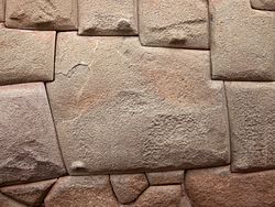
Megalithic
The talud-tablero style used in many Mesoamerican pyramids and a prominent stylistic feature of Teotihuacano architecture
An architectural construction technique that employs large dry-laid limestone blocks (c. 1 m × 50cm × 30cm) covered with a thick layer of stucco. This style was common in the northern Maya lowlands from the Preclassic until the early parts of the Early Classic.
Pyramids in Mesoamerican were platformed pyramids and many used a style called talud-tablero, which first became common in Teotihuacan. This style consists of a platform structure, or the "tablero," on top of a sloped "talud". Many different variants on the talud-tablero style arose throughout Mesoamerica, developing and manifesting itself differently among the various cultures.
So named after the Puuc hills in which this style developed and flourished during the latter portion of the Late Classic and throughout the Terminal Classic in the northern Maya lowlands, Puuc architecture consists of veneer facing stones applied to a concrete core. Two façades were typically built, partitioned by a ridge of stone. The blank lower façade is formed by flat cut stones and punctuated by doorways. The upper partition is richly decorated with repeating geometric patterns and iconographic elements, especially the distinctive curved-nosed Chaac masks. Carved columnettes are also common.
Technology
Corbelled arch
The principle of the "false" or corbelled arch is to build it without a keystone, but just with overlapping tiers of blocks
Mesoamerican cultures never invented the keystone, and so were unable to build true arches, but instead, all of their architecture made use of the "false" or Corbelled arch. These arches are built without centering and can be built without support, by corbelling regularly the horizontal courses of the wall masonry. This type of arch supports much less weight than a true arch.
However, recent work by engineer James O'Kon suggests the Mesoamerican "arch" is technically not a corbelled arch at all but a trapezium truss system. Moreover, unlike a corbelled arch, it does not rely on overlapping layers of blocks but cast-in-place concrete often supported by timber thrust beams. Computer analysis reveals this to be structurally superior to a curved arch[26][dubious–discuss]
True arch
Scholars such as David Eccott and Gordon Ekholm argue that true arches were known in pre-Columbian times in Mesoamerica; they point to various examples of true arches at a Maya site in La Muneca, the facade of Temple A at Nukum, two low domes at Tajin in Veracruz, a sweat bath at Chichen Itza, and an arch at Oztuma.[27][28][29] In 2010, a robot discovered a long arch-roofed passageway underneath the Pyramid of Quetzalcoatl, which stands in the ancient city of Teotihuacan north of Mexico City, dated to around 200 AD.[30]
UNESCO World Heritage Sites
A number of important archeological sites representing Mesoamerican architecture have been categorized as "World Heritage Sites" by the UNESCO.[31]
↑Mary Miller and Karl Taube, introduction to "The Gods and Symbols of Ancient Mexico and the Maya" p. 30.
↑Mary Miller and Karl Taube write about this in their introduction to "The Gods and Symbols of Ancient Mexico and the Maya" pp. 31, they attribute this interpretation to Epigrapher David Stuart. American archeologist James E. Brady have done extensive research on importance of caves in Mesoamerican culture. The title of the famous book "Forest of Kings" by Mayanist Linda Schele also alludes to the Mayan belief that stelae represent trees, especially the world tree, axis mundi of the Mayan cosmos.
↑Šprajc, Ivan; Sánchez Nava, Pedro Francisco (2018). "El Sol en Chichén Itzá y Dzibilchaltún: la supuesta importancia de los equinoccios en Mesoamérica". Arqueología Mexicana. 25 (149): 26–31.
↑Aveni and Gibbs. Other researchers give other estimates or averages, but there is a remarkable consistency across time and space to this general orientation.
↑In Chapter 22 of Archaeoastronomy in the Americas, edited by Ray A. Williamson, Ballena Press/Center for Archaeoastronomy, 1981, pp. 249–61, which can also be found at his websiteArchived 2006-11-03 at the Wayback Machine . See also John Q Jacobs article for more information on the alignments of Mesoamerican Cities
↑Aveni, Anthony F. (2001). Skywatchers: A Revised and Updated Version of Skywatchers of Ancient Mexico. Austin: University of Texas Press. ISBN978-0-292-70504-3.
↑Šprajc, Ivan (2018). "Astronomy, Architecture, and Landscape in Prehispanic Mesoamerica". Journal of Archaeological Research. 26 (2): 197–251. doi:10.1007/s10814-017-9109-z. S2CID149439162.
↑Šprajc, Ivan (2015). "Governor's Palace at Uxmal". In Ruggles, Clive L. N. (ed.). Handbook of Archaeoastronomy and Ethnoastronomy. New York: Springer. pp.773–781. Bibcode:2015hae..book.....R.
This page is based on this Wikipedia article Text is available under the CC BY-SA 4.0 license; additional terms may apply. Images, videos and audio are available under their respective licenses.