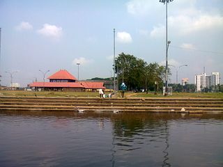
Aluva is a municipality in the Ernakulam district of Kerala, India. Aluva is situated 14.5 km (9.0 mi) from Kochi along the banks of Periyar River, and is a part of the Kochi metropolitan area. Aluva is a major transportation hub, connecting North Malabar and Central Kerala to Kochi. The Cochin International Airport at Nedumbassery, located 11.7 km from Aluva, is an important aviation hub which hosts both domestic and international flights. Aluva is also the northern terminus of the Kochi metro.
Edappally is a ward of Kochi, Kerala. The name is also used to refer to adjacent wards of Kalamassery and Thrikkakkara municipalities. Edappally is a major commercial centre as well as a prominent residential region. Edappally junction is one of the busiest junctions in the city.

Greater Cochin Development Authority (GCDA) is the statutory body overseeing the development of the city of Kochi in the state of Kerala, India. Headquartered at Kadavanthra, GCDA oversees the development of the major part of Greater Cochin area which consists of the Kochi Municipal Corporation, surrounding municipalities and 21 intervening panchayats covering an area of 632 km2.
Eloor is a municipality in the Ernakulam district of Kerala, India. It is an industrial area situated around 13 kilometres north of the Kochi city centre, and is a part of the Kochi metropolitan area. It is an island of 14.21 km2 formed between two distributaries of river Periyar and is the largest industrial belt in Kerala. The neighbouring places of Eloor are Kalamassery industrial hub, Aluva, Cheranalloor and Paravur.

Kalamassery is a municipality in the Ernakulam district of Kerala, India. It is located 9.6 km (6.0 mi) northeast of the Kochi centre, and is a part of the Kochi metropolitan area. The area's location along the NH 66 and proximity to the IT centres in Kakkanad has enabled it to see a large spurt in economic development since the 1980s.
Kochi is a major port city in the Indian state of Kerala. The city is widely known as the commercial or economic capital of the state of Kerala.

Palarivattom is a ward of Kochi, Kerala. The region makes a four-directional intersection at its highway signal point on the Kochi Bypass, which leads to :

Kadavanthra is a ward in downtown Kochi, Kerala. It is bounded by the S.A Road to the north and the Giri Nagar canal in the west. Kadavanthra is a major commercial centre of Kochi, and a prime residential area. In recent years, the ward has undergone rapid development to become one of Kochi's highest-valued regions. The S.A Road is Kadavanthra's main arterial roads, and connects it to the Vyttila interchange in the east.
Kangarappady is a suburban region in Kochi, Kerala, India.

Pachalam is a region in the city of Kochi in Kerala, India. Goshree bridge road at Marine Drive side ends at Pachalam. Pachalam can also be reached by Chittoor Road. Mulavukad island is on its west, Vaduthala and Chittoor island is on its north, Elamakkara at north east, Mamagalam and Palarivattom is on its east, Kaloor on southeast. It is also located between Marine Drive, Kaloor and Edapally acting as a connecting link between the most important places in Kochi. One of the main attractions near Pachalam is the famous Queen's Walkway, that connects Pachalam to the Gosree bridge Road and to Marine Drive. Although the roads are very narrow, the traffic has increased, as roads inside Pachalam give a much needed respite to motorists who were looking an alternative to escape from the hardships of motoring through Banerjee Road especially during this phase of Kochi Metro construction.
Thevara is a ward of Kochi, Kerala.
Nettoor is a region in the city of Kochi. It is around 5 km (3.1 mi) from Vytilla Junction and around 8 km (5.0 mi) from Ernakulam Junction Railway Station. Nettoor is located on Panangad Island and is a part of Maradu Municipality.
Vyttila, IPA: [ʋɐjt̺ːilɐ], is a ward of Kochi, Kerala. The Vyttila junction is one of the busiest as well as one of the largest intersections in Kerala. This node intersects the main north–south artery of the state of Kerala, namely, the Kochi Bypass, with three city roads of Kochi viz, the S. A. Road, the Vyttila-Petta Road, and the Thammanam Road.

Kaloor is a downtown region in the city of Kochi, in the state of Kerala, India. It is two kilometres (1.2 mi) from the Ernakulam North Railway Station. Kaloor Junction is also the name of a major intersection in this part of the city, intersecting the two major arteries of downtown Kochi, namely Banerji Road and the Kaloor-Kadavanthra Road. The nearest major intersections are Palarivattom to the east and Lissie Junction to the west.
Sahodaran Ayyappan Road, popularly known as S.A Road is one of the most important and the second main arterial road of CBD Kochi city ; it is supposed to be the busiest and most congested road in the city of Kochi, which run in east-west direction and the shortest road connecting the two main iconic junctions in the city. The road connects the MG Road in west with Vyttila Junction & Hub in east and continues further as Tripunithura Road that connects to Tripunithura, hence termed as the back bone road of Kochi.
This is a list of areas and neighbourhoods in Cochin by region.
Kaloor-Kadavanthra Road a major arterial road of Kochi City, also known as KK Road is one of the three north-south arteries in the city of Kochi. Kaloor-Kadavanthra Road starts from Kadavanthra Junction and ends at Kaloor, the two major junctions in the city of Kochi. Kaloor-Kadavanthra Road intersects the Sahodaran Ayyappan Road from Vytila (East) to Pallimukku Junction (West) at Kadavanthra Junction. The South extension of the Kaloor-Kadavanthra Road is the KP Vallon Road. Most of the long distance buses that connect the city to the regions to the south and southeast use this road to reach their main terminal at Kaloor. This 3.2 km long, 22 m wide, 4-lane city highway was planned to ease the load on the busy MG Road. The city is divided into two parts by the railway line running in a north-south direction. This road fills the need for an artery on the eastern sector, avoiding the choke points of the two railway overpasses. The road also has many prominent banks along its route like the State Bank of India at Grand bay, ICICI, Bank of India, HDFC, Central Bank of India -Kallelil Building, Kadavanthra Jn: etc. The road was in a pitiable conditions before this modern state.

Panampilly Nagar is a ward of Kochi, Kerala.. It is an upscale area of downtown Kochi, with both commerical and residential developments. It is a busy upmarket residential area in Kadavanthra region just 1 km east of M.G Road, the center of Kochi city.

Kaprassery is a village in the district of Ernakulam and is situated on the National Highway 544 (India) that stretches from Salem to Kochi. It is located between the two major towns of the Indian state Kerala, namely, Aluva and Angamaly.
