The Weser is a river of Lower Saxony in north-west Germany. It begins at Hannoversch Münden through the confluence of the Werra and Fulda. It passes through the Hanseatic city of Bremen. Its mouth is 50 km (31 mi) further north against the ports of Bremerhaven and Nordenham. The latter is on the Butjadingen Peninsula. It then merges into the North Sea via two highly saline, estuarine mouths.

The Elbe is one of the major rivers of Central Europe. It rises in the Giant Mountains of the northern Czech Republic before traversing much of Bohemia, then Germany and flowing into the North Sea at Cuxhaven, 110 kilometres northwest of Hamburg. Its total length is 1,094 km (680 mi).

The Elbe–Lübeck Canal is an artificial waterway in eastern Schleswig-Holstein, Germany. It connects the rivers Elbe and Trave, creating an inland water route across the drainage divide from the North Sea to the Baltic Sea. The canal includes seven locks and runs for a length of 64 kilometres (40 mi) between the cities of Lübeck in the north and Lauenburg in the south by way of the Mölln lakes. The modern canal was built in the 1890s to replace the Stecknitz Canal, a medieval watercourse linking the same two rivers.

The Aller[ˈalɐ] is a 215-kilometre-long (134 mi) river in the states of Saxony-Anhalt and Lower Saxony in Germany. It is a right-hand, and hence eastern, tributary of the Weser and is also its largest tributary. Its last 117 kilometres (73 mi) form the Lower Aller federal waterway (Bundeswasserstraße). The Aller was extensively straightened, widened and, in places, dyked, during the 1960s to provide flood control of the river. In a 20-kilometre-long (12 mi) section near Gifhorn, the river meanders in its natural river bed.

The Havel is a river in northeastern Germany, flowing through the states of Mecklenburg-Vorpommern, Brandenburg, Berlin and Saxony-Anhalt. It is a right tributary of the Elbe and 325 kilometres (202 mi) long. However, the direct distance from its source to its mouth is only 94 kilometres (58 mi). For much of its length, the Havel is navigable; it provides an important link in the waterway connections between the east and west of Germany, as well as beyond.

Neuwerk (pronunciation ; is a 3 km2 tidal island in the Wadden Sea on the German North Sea coast, with a population of 32. Neuwerk is located 13 km northwest of Cuxhaven, between the Weser and Elbe estuaries. The distance to the centre of Hamburg is about 120 km.

The Mittelland Canal, also known as the Midland Canal, is a major canal in central Germany. It forms an important link in the waterway network of that country, providing the principal east-west inland waterway connection. Its significance goes beyond Germany as it links France, Switzerland and the Benelux countries with Poland, the Czech Republic and the Baltic Sea.

Oste is a river in northern Lower Saxony, Germany with a length of 156 km (97 mi). It is a left tributary of the Elbe.

Wangerooge is one of the 32 Frisian Islands in the North Sea located close to the coasts of the Netherlands, Germany and Denmark. It is also a municipality in the district of Friesland in Lower Saxony in Germany.

Bremerhaven is a city at the seaport of the Free Hanseatic City of Bremen, a state of the Federal Republic of Germany.
The Stade Region emerged in 1823 by an administrative reorganisation of the dominions of the Kingdom of Hanover, a sovereign state, whose then territory is almost completely part of today's German federal state of Lower Saxony. Until 1837 the Kingdom of Hanover was ruled in personal union by the Kings of the United Kingdom of Great Britain and Ireland.

The region between the Elbe and Weser rivers forms the Elbe–Weser triangle, also rendered Elbe-Weser Triangle, in northern Germany. It is also colloquially referred to as the Nasses Dreieck or "wet triangle".
The Aller Canal is a canal built in the mid-19th century in the German state of Lower Saxony. The canal is 18 kilometres (11 mi) long and runs between Wolfsburg and Gifhorn. It was built to protect agricultural land from flooding by the river Aller. The nearly straight canal carries water from the Aller more quickly than the river itself can in its meandering course through this section of the old glacial valley.

Söse is a river of Lower Saxony, Germany. It is a right tributary of the river Rhume and 38 kilometres (24 mi) long.

The Geeste is a river in northwestern Germany, running through Lower Saxony and Bremen. It is the most downstream tributary of the River Weser and joins it near Bremerhaven. The Geeste rises in Hipstedt in the district of Rotenburg (Wümme) ten kilometres west of Bremervörde and drains a large part of the old district of Wesermünde.

The Ochtum is a river in Lower Saxony and Bremen, Germany. Roughly 26 km (16 mi) long, it is a left tributary of the Weser.
Land Hadeln is a historic landscape and former administrative district in Northern Germany with its seat in Otterndorf on the Lower Elbe, the lower reaches of the River Elbe, in the Elbe-Weser Triangle between the estuaries of the Elbe and Weser.
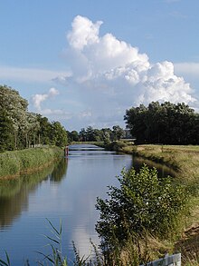
The Dadau is a left tributary of the river Hunte. For most of its upper course it forms the boundary between the districts of Diepholz and Vechta and for a shorter distance along its lower reaches it forms the boundary between the town of Diepholz and the collective municipality of Barnstorf.
The Wesermünde Geest is the collective name for several geest ridges in the west of Cuxhaven district and Bremen's North Borough in northern Germany. The ridges are separated from one another by wetlands. These terminal moraines were formed during the Saale glaciation, are up to between 10 to 70 m above sea level (NN), and are covered by scattered woods and farmland. The wetland areas, between 0 to 5 m above sea level, are predominantly used for grazing.

Pundt & Kohn OHG was a German timber import and wood processing company. It was founded in 1862 by F. J. S. Kohn in Geestemünde. Until it was destroyed by Allied bombing in 1944, it was one of the oldest and most important companies in its branch on the lower Weser. The company was dissolved in the third generation in 1967 after the death of its last owner, Hans Kohnert.