Related Research Articles

Rift Valley Province of Kenya, bordering Uganda, was one of Kenya's eight provinces, before the Kenyan general election, 2013. Rift Valley Province was the largest and one of the most economically important provinces in Kenya. It was dominated by the Kenya Rift Valley which passes through it and gives the province its name. According to the 2009 Census, the former province covered an area of 182,505.1 square kilometres and would have had a population of 10,006,805, making it the largest and most populous province in the country. The bulk of the provincial population inhabited a strip between former Nairobi and Nyanza Province. The capital was the town of Nakuru.

The Tugen are a sub tribe of the Kenyan Kalenjin people. They fall under the highland nilotes category. They occupy Baringo County and some parts of Nakuru County and Elgeyo Marakwet County in the former Rift Valley Province. Daniel Arap Moi, the second president of Kenya (1978–2002), came from this sub-tribe. The Tugen people speak the Tugen language. The Tugen population was 197,556 as of 2019.

Uasin Gishu County is one of the 47 counties of Kenya located in the former Rift Valley Province. Eldoret has the county's largest population centre as well as its administrative and commercial centre. “It lies between longitudes 34 degrees 50’ east and 35 degrees 37’ West and latitudes 0 degrees 03’ South and 0 degrees 55’ North. It is a highland plateau with altitudes falling gently from 2,700 meters above sea level to about 1,500 meters above sea level. The topography is higher to the east and declines gently towards the western border”.
The Marakwet are one of the groups forming the ethnolinguistic Kalenjin community of Kenya, they speak the Markweta language. The Marakwet live in five territorial sections namely Almoo, Cherangany, Endoow, Sombirir (Borokot) and Markweta. Cutting across these territorial groups are a number of clans to which each Marakwet belongs. There were 119,969 Marakwet people in 2019.
[>>Published by Alberto<<]
Marakwet District is a defunct administrative district in the former Rift Valley Province of Kenya. Its capital town was Kapsowar. The district had a population of 140.629. Local people are predominantly of the Marakwet tribe.
Keiyo District is a defunct administrative district in the former Rift Valley Province of Kenya. The district was formed in 1994, when the Elgeyo-Marakwet District was split into two — the other half was Marakwet District. Keiyo District had a population of 143.865. Its capital was located in the Iten/Tambach town. In 2010, the districts were re-joined as Elgeyo-Marakwet County.
Changach is a village in the Keiyo District, Elgeyo-Marakwet County, Kenya. It was formerly in the Rift Valley Province. According to the 2019 census it has a population of 1384 living in 301 households.
Kapcherop is a town and administrative division of Elgeyo-Marakwet County, Kenya. Prior to March 2013, it was located in the Marakwet District, Rift Valley Province.

The Cherang'any Hills are a range of hills in the western highlands of Kenya. The hills are one of Kenya's five main forests and catchment areas. The highlands, the large central plateau, is divided by the Mau Escarpment which rises from the border with Tanzania up to the Cherang'any Hills. The escarpment bounds the plateau that rises to the slopes of Mount Elgon. The Cherangany Hills span three counties namely Trans Nzoia, Elgeyo Marakwet and West Pokot. The highest point of the range is the summit of Nakugen at 3530 m, which can be ascended from the south from parking space at a Kenyan Wildlife Service station, located at 1.16284°N 35.49325°E. Other notable peaks include; Chemnirot (3520 m), Kameleogon (3500 m), Chebon (3375 m), Chepkotet (3370 m), Karelachgelat (3350 m) and Sodang (3211 m). They are home to a marginalized hunter-gatherer community called the Sengwer.
Tambach Teachers College is a college in Tambach, Elgeyo-Marakwet County, Kenya. It is one of the 20 public primary teachers colleges in Kenya and among the last five of such institutions constructed in the late 1980s by the government of Kenya through the support of the World Bank. The college is situated in the Kerio escarpment section of Elgeyo-Marakwet County along the Eldoret-Kabarnet road. The college is 43 km from Eldoret and 11 km from Iten, the District Headquarters.
Chepkum is a settlement in Kenya's Elgeyo-Marakwet County. It was a part of the former Rift Valley Province.

The Great Rift Valley is part of an intra-continental ridge system that runs through Kenya from north to south. It is part of the Gregory Rift, the eastern branch of the East African Rift, which starts in Tanzania to the south and continues northward into Ethiopia. It was formed on the "Kenyan Dome" a geographical upwelling created by the interactions of three major tectonics: the Arabian, Nubian, and Somalian plates. In the past, it was seen as part of a "Great Rift Valley" that ran from Madagascar to Syria. Most of the valley falls within the former Rift Valley Province.

Sub-counties, formerly known as Districts, are the decentralised units through which government of Kenya provides functions and services. Except for the parts which fall under urban areas, sub-counties will coincide with the constituencies created under article 89 of the Constitution of Kenya. Most sub-counties have a sub-county administrator, appointed by a County Public Service Board. Even though the sub-counties are divisions of counties, powers to create new sub-counties lies with the national government. As of 2023, there are 314 sub-counties, compared to 290 constituencies. A deputy county commissioner is appointed by the state to lead each sub-county.
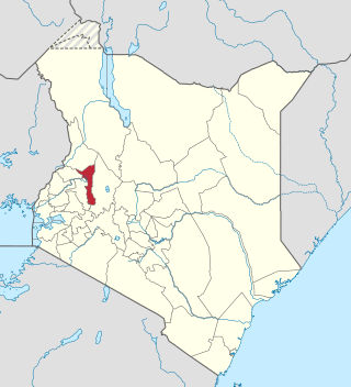
Elgeyo-Marakwet County is one of Kenya's 47 counties, which is located in the former Rift Valley Province with its capital and largest town as Iten. It borders the counties of West Pokot to the north, Baringo County to the east, southeast and south, Uasin Gishu to the southwest and west, and Trans Nzoia to the northwest.
West Pokot District, formerly known as West Suk or Kacheliba District, was an administrative district in the Rift Valley Province of Kenya. Its capital town was Kapenguria.
Uasin Gishu District, also known as Eldoret District, was one of the districts of Kenya, located in the Rift Valley Province. The town of Eldoret was its capital, administrative and commercial centre. It bordered the Trans-Nzoia District.
Trans-Nzoia District was an administrative district of Rift Valley Province, Kenya, located between the Nzoia River and Mount Elgon with its centre at the town of Kitale.
Nandi District was an administrative district in the Rift Valley Province of Kenya. Its capital town was Kapsabet.
Laikipia District was a district of Kenya, located on the Equator in the Rift Valley Province of the country. The district had two major urban centres: Nanyuki to the southeast, and Nyahururu to the southwest. Its capital was Nanyuki.
References
- ↑ "Kenya Districts". www.statoids.com. Retrieved 2023-09-22.
- ↑ "description of the districts and provinces". Syracuse University. p. 6. Retrieved 18 October 2023.
- ↑ "Kenya Gazette dated 2nd April, 1963" (PDF). Gazettes.Africa. Retrieved 18 October 2023.
- ↑ "The 2009 Kenya Population and Housing Census" (PDF). Amazonaws. p. 198. Retrieved 18 October 2023.
0°56′54″N35°30′31″E / 0.94833°N 35.50861°E
| | This Rift Valley Province location article is a stub. You can help Wikipedia by expanding it. |