
Eldoret is town and urban centre in Kenya. Gazetted as a municipality, it is in the Rift Valley region, and it serves as the capital of Uasin Gishu County. The town was referred to by white settlers as Farm 64 and colloquially by locals as 'Sisibo'. As per the 2019 population census, Eldoret is the fifth most populated urban area in the country after Nairobi, Mombasa, Nakuru and Ruiru. Lying south of the Cherangani Hills, the local elevation varies from about 2,100 metres (6,900 ft) at the airport to more than 2,700 metres (8,900 ft) in nearby areas. The population was 289,380 in the 2009 Census, and it was the fastest growing city in Kenya with 475,716 people according to 2019 National Census. Eldoret was on course to be named Kenya's fourth city, but was edged out by Nakuru in 2021.

The Kalenjin are a group of tribes indigenous to East Africa, residing mainly in what was formerly the Rift Valley Province in Kenya and the Eastern slopes of Mount Elgon in Uganda. They number 6,358,113 individuals per the Kenyan 2019 census and an estimated 273,839 in Uganda according to the 2014 census mainly in Kapchorwa, Kween and Bukwo districts.

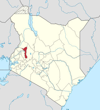
Trans-Nzoia County is a county in the former Rift Valley Province, Kenya, located between the Nzoia River and Mount Elgon, 380 km northwest of Nairobi. At its centre is the town of Kitale which is the capital and largest town. The county borders Bungoma to the west, Uasin Gishu and Kakamega to the south, Elgeyo-Marakwet to the east, West Pokot to the north and the Republic of Uganda to the Northwest. Trans Nzoia covers an area of 2495.5 square kilometres.

Uasin Gishu County is one of the 47 counties of Kenya located in the former Rift Valley Province. Eldoret has the county's largest population centre as well as its administrative and commercial centre. "It lies between longitudes 34 degrees 50' east and 35 degrees 37' West and latitudes 0 degrees 03' South and 0 degrees 55' North. It is a highland plateau with altitudes falling gently from 2,700 meters above sea level to about 1,500 meters above sea level. The topography is higher to the east and declines gently towards the western border".
The Elgeyo are an ethnic group who are part of the larger Kalenjin ethnic group of Nilotic origin. They live near Eldoret, Kenya, in the highlands of the former Keiyo District, now part of the larger Elgeyo Marakwet County. The Elgeyo originally settled at the foothills of the Elgeyo escarpment, in the area between Kerio river to the east and the escarpment to the west. Due to drought and famine in the valley, the Keiyos climbed the escarpment and started to settle on the highland east of Uasin Gishu plateau. When the British came, the Keiyos were pushed to settle in clusters called reserves.
The Marakwet are one of the groups forming the ethnolinguistic Kalenjin community of Kenya, they speak the Markweta language. The Marakwet live in five territorial sections namely Almoo, Cherangany, Endoow, Sombirir (Borokot) and Markweta. Cutting across these territorial groups are a number of clans to which each Marakwet belongs. There were 119,969 Marakwet people in 2019.
Keiyo District is a defunct administrative district in the former Rift Valley Province of Kenya. The district was formed in 1994, when the Elgeyo-Marakwet District was split into two — the other half was Marakwet District. Keiyo District had a population of 143.865. Its capital was located in the Iten/Tambach town. In 2010, the districts were re-joined as Elgeyo-Marakwet County.

Nandi County is a county in Kenya in the North Rift, occupying an area of 2,884.4 square kilometres. Its capital, Kapsabet, is the largest town in the county while other towns include Mosoriot, Tinderet, Kobujoi, Kaiboi, Kabiyet and Nandi Hills. According to a 2019 census, the county has a population of 885,711, made up of a number of Kenyan communities, the majority of whom belong to the native tribe called Nandi.
Kaptagat is a settlement in Uasin Gishu County, in the southwestern part of Kenya. This part of the country, where the two counties of Uasin Gishu and Elgeyo Marakwet County share a border, is used by the majority of Kenyan professional long-distance runners to train for professional competition. Eliud Kipchoge, the former marathon world record holder, who also doubles as the Tokyo Olympics and Rio Olympics marathon gold medalist, maintains a training camp in Kaptagat.
Moi's Bridge is a small town that has its roots both in Uasin Gishu County, Trans Nzoia County and Kakamega County, Kenya. It is a town that has since grown as an agricultural center with the third largest NCPB in East Africa. Moi's Bridge is an electoral ward of the Soy Constituency and Uasin Gishu County. It is an important Kenyan area, often named as the 'bread basket' of Kenya. Moi's Bridge is also a location in the Soy division of Uasin Gishu District.

Sub-counties, also known as Districts, are the decentralised units through which government of Kenya provides functions and services. At national level, sub-counties take a more administrative function like security, statistical purposes, provision of government services, etc. Even though the sub-counties are divisions of counties, powers to create new national sub-counties lies with the national government. As of 2023, there are 314 sub-counties, compared to 290 constituencies. A deputy county commissioner is appointed by the state to lead each sub-county. The sub-counties are further divided into divisions, locations and sub-locations.
Elgeyo-Marakwet County is one of Kenya's 47 counties, which is located in the former Rift Valley Province with its capital and largest town as Iten. It borders the counties of West Pokot to the north, Baringo County to the east, southeast and south, Uasin Gishu to the southwest and west, and Trans Nzoia to the northwest.
Trans-Nzoia District was an administrative district of Rift Valley Province, Kenya, located between the Nzoia River and Mount Elgon with its centre at the town of Kitale.

Paul Kiplimo Boit was a prominent KANU politician during the Moi Regime. He was the Chairman of Sirikwa County Council (which later came to be divided to Nandi County, Uasin Gishu County, Trans Nzoia County, West Pokot County Elgeyo Marakwet County from 1964 to 1971 and later became the Chairman of Wareng County Council one of five Councils split from Sirikwa covering Uasin Gishu. He was best known for his excellent farming skills which earned him many awards and a visit from the former Tanzanian president Ali Hassan Mwinyi
Sirikwa holes are saucer-shaped hollows found on hillsides in the western highlands of Kenya and in the elevated stretch of the central Rift Valley around Nakuru. These hollows, each having a diameter of 10–20 metres and an average depth of 2.4 metres, occur in groups, sometimes numbering fewer than ten and at times more than a hundred. Archaeologists believe that construction of these features may have begun in the Iron Age.
The Sengwer people are an indigenous community who primarily live in the Embobut forest in the western highlands of Kenya and in scattered pockets across Trans Nzoia, West Pokot and Elgeyo-Marakwet counties. The Sengwer are sometimes portrayed as a component of the Marakwet people but are a distinct ethnic grouping.
The Chemwal people were a Kalenjin-speaking society that inhabited regions of western and north-western Kenya as well as the regions around Mount Elgon at various times through to the late 19th century. The Nandi word Sekker was used by Pokot elders to describe one section of a community that occupied the Elgeyo escarpment and whose territory stretched across the Uasin Gishu plateau. This section of the community appears to have neighbored the Karamojong who referred to them as Siger, a name that derived from the Karimojong word esigirait. The most notable element of Sekker/Chemwal culture appears to have been a dangling adornment of a single cowrie shell attached to the forelock of Sekker women, at least as of the late 1700s and early 1800s.
The Sirikwa culture was the predominant Kenyan hinterland culture of the Pastoral Iron Age, c.2000 BP. Seen to have developed out of the Elmenteitan culture of the East African Pastoral Neolithic c.3300-1200 BP, it was followed in much of its area by the Kalenjin, Maa, western and central Kenyan communities of the 18th and 19th centuries.
The Siger people were a community commonly spoken of in the folklore of a number of Kenyan communities that inhabited regions of northwestern Kenya at various points in history.
Elgeyo-Marakwet District, also referred to as Tambach District during the colonial period, was one of the districts of Kenya, located in the Rift Valley Province. Its capital was Tambach.