Related Research Articles

Trans-Nzoia County is a county in the former Rift Valley Province, Kenya, located between the Nzoia River and Mount Elgon, 380 km northwest of Nairobi. At its centre is the town of Kitale which is the capital and largest town. The county borders Bungoma to the west, Uasin Gishu and Kakamega to the south, Elgeyo-Marakwet to the east, West Pokot to the north and the republic of Uganda to the Northwest. Trans Nzoia covers an area of 2495.5 square kilometres.

Uasin Gishu County is one of the 47 counties of Kenya located in the former Rift Valley Province. Eldoret has the county's largest population centre as well as its administrative and commercial centre. “It lies between longitudes 34 degrees 50’ east and 35 degrees 37’ West and latitudes 0 degrees 03’ South and 0 degrees 55’ North. It is a highland plateau with altitudes falling gently from 2,700 meters above sea level to about 1,500 meters above sea level. The topography is higher to the east and declines gently towards the western border”.
Kapsowar is a town in Elgeyo-Marakwet County, Kenya. Prior to March 2013, it was located in the former Rift Valley Province. In 1994, Kapsowar became the headquarters of the former Marakwet district.Furthermore,Kapsowar is the proposed headquarters for the great Marakwet County. Prior to this, the Marakwet and Keiyo tribes were collectively grouped into the Elgeiyo-Markwet District. In 2010, the two districts were again merged into Elgeyo-Marakwet County. The Marakwet number approximately 200,000 and are a part of the Kalenjin family of tribes, which collectively are the second-largest ethnic group in Kenya.
Keiyo District is a defunct administrative district in the former Rift Valley Province of Kenya. The district was formed in 1994, when the Elgeyo-Marakwet District was split into two — the other half was Marakwet District. Keiyo District had a population of 143.865. Its capital was located in the Iten/Tambach town. In 2010, the districts were re-joined as Elgeyo-Marakwet County.

Iten is a town in Elgeyo-Marakwet County in the Republic of Kenya. Iten serves as the capital and is the largest town in the county. The town is located along the road between Eldoret and Kabarnet at the junction of the road heading to Kapsowar. Elgeyo escarpment and Kerio River are located east of Iten. The growing town had a population of 42,312 at the 2009 consensus.
West Pokot County is a county of Kenya. Its capital and largest town is Kapenguria. The county covers an area of approximately 9,169.4 square kilometers and stretches a distance of 132 kilometers from north to south. West Pokot County is bordered to the north by Turkana County, to the east by Baringo County, to the southeast by Elgeyo-Marakwet County, to the south by Trans Nzoia County and to the west by Uganda. According to the 2019 census, the county has a population of 621,241. The county is home to Tegla Loroupe, one of the most famous Kenyan female runners.
Changach is a village in the Keiyo District, Elgeyo-Marakwet County, Kenya. It was formerly in the Rift Valley Province. According to the 2019 census it has a population of 1384 living in 301 households.
Kapatarakwa is a village in Elgeyo-Marakwet County, Kenya. Kaptarakwa is located about 37 km from the town of Eldoret in the Kenyan highlands. Kaptarakwa is about 8,000 feet (2,400 m) above sea level. Nearby is the Kerio Escarpment which drops down to 1,000 feet (300 m) above sea level.
Kapcherop is a town and administrative division of Elgeyo-Marakwet County, Kenya. Prior to March 2013, it was located in the Marakwet District, Rift Valley Province.
Marakwet East is an electoral constituency in Kenya. It is one of four constituencies of Elgeyo-Marakwet County. Between 1992 and 2012, the constituency had eleven wards, all of which elected councillors for the defunct Marakwet County Council. However, after the promulgation of the new constitution, the constituency was subdivided into four wards: Embobut/Embolot, Endo, Kapyego, and Sambirir.
Keiyo South is an electoral constituency in Kenya. It is one of four constituencies of Elgeyo-Marakwet County. The constituency has 6 wards, all of which elect Member of County Assembly (MCA) for the Elgeyo Marakwet County which seats in the county Headquarters, Iten. The wards are namely: Metkei, Kabiemit, Chepkorio, Soy South and Soy North. The constituency was established for the 1969 elections. It was one of two constituencies of the former Keiyo District.
Marakwet West is an electoral constituency in Kenya. It is one of four constituencies of Elgeyo-Marakwet County. The constituency has six wards, all of which elect councillors for the Marakwet County Council. The constituency was established for the 1997 elections. It was one of two constituencies in the former Marakwet District.
Kimwarer is a village in Elgeyo-Marakwet County, Kenya. It is located along the B54 Road between Eldoret and Tenges, in the southern part of Kerio Valley and in the drainage basin area of the Kerio River. One of the nearest villages is Kaptagat, located 10 kilometres west of Kimwarer on the Highlands. The nearest larger town, Eldoret, is 50 kilometres west of Kimwarer. Electorally Kimwarer is part of the Soy ward of Keiyo South Constituency and Keiyo County Council.
Embobut is one of the administrative wards for the Marakwet East Constituency in Elgeyo-Marakwet County, Kenya. The area contains one of two major drainage basins for Elgeyo-Marakwet County, referred to locally as a "water towers". The other water tower in Elgeyo-Marakwet County is Cherangani Hills. Embobut supplies Eldoret town and its environs with water. Collectively the Embobut and Cherangani Hills water towers also supply water to the Kerio River, which flows through the Cheploch Gorge in Baringo to Lake Turkana via the Turkwel Gorge.
Chesoi is a small town in Elgeyo Marakwet County in the former Rift Valley Province of Kenya. The town hosts the region's historical monuments such as Chorwó Kimikeu, Chesoi Primary School, Chesoi Health Centre, and Chesoi Catholic Parish.

Sub-counties, formerly known as Districts, are the decentralised units through which government of Kenya provides functions and services. Except for the parts which fall under urban areas, sub-counties will coincide with the constituencies created under article 89 of the Constitution of Kenya. Most sub-counties have a sub-county administrator, appointed by a County Public Service Board. Even though the sub-counties are divisions of counties, powers to create new sub-counties lies with the national government. As of 2023, there are 314 sub-counties, compared to 290 constituencies. A deputy county commissioner is appointed by the state to lead each sub-county.
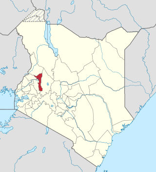
Elgeyo-Marakwet County is one of Kenya's 47 counties, which is located in the former Rift Valley Province with its capital and largest town as Iten. It borders the counties of West Pokot to the north, Baringo County to the east, southeast and south, Uasin Gishu to the southwest and west, and Trans Nzoia to the northwest.
Uasin Gishu District, also known as Eldoret District, was one of the districts of Kenya, located in the Rift Valley Province. The town of Eldoret was its capital, administrative and commercial centre. It bordered the Trans-Nzoia District.
Trans-Nzoia District was an administrative district of Rift Valley Province, Kenya, located between the Nzoia River and Mount Elgon with its centre at the town of Kitale.
Elgeyo-Marakwet District, also referred to as Tambach District during the colonial period, was one of the districts of Kenya, located in the Rift Valley Province. It's capital was Tambach.
References
- ↑ "Status of Coverage of Communications Services" (PDF). Communications Commission of Kenya. Archived from the original (PDF) on 28 September 2007. Retrieved 26 November 2007.
- ↑ "Population of local authorities" (PDF). Kenya National Bureau of Statistics. Archived from the original (PDF) on 28 September 2007. Retrieved 26 November 2007.
| International | |
|---|---|
| National | |
0°56′54″N35°30′31″E / 0.94833°N 35.50861°E
| | This Rift Valley Province location article is a stub. You can help Wikipedia by expanding it. |