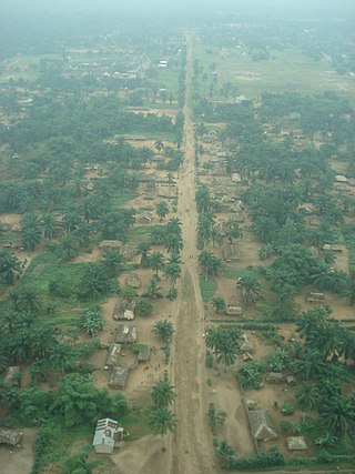
Kole is a remote town in central Democratic Republic of the Congo on the Lukenie River. It is the administrative center of the Kole Territory, which in turn is part of Sankuru Province. Kole is sometimes designated "Kole Sur Lukenie" to distinguish it from other "Koles" in the DRC.
The Roman Catholic Diocese of Kole is a diocese located in the city of Kole in the Ecclesiastical province of Kananga in the Democratic Republic of the Congo. It is coterminous with the Territoires ("counties") of Kole, Dekese and Lomela.

The Chemin Neuf Community is a Catholic community with an ecumenical vocation. Formed from a charismatic prayer group in 1973, it has 2,000 permanent members in 30 countries, and 12,000 people serving in the community missions. Its main founder is the Jesuit father, Laurent Fabre.
Sankuru Nature Reserve is a protected area in the Democratic Republic of the Congo. It was created in November 2007 to protect a forest area home to bonobo, okapi and African forest elephant. The reserve has not been managed effectively, and suffers from ongoing deforestation and bushmeat hunting.
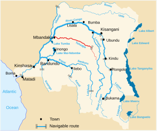
The Tshuapa River or Rivière Tshwapa is a river in Democratic Republic of the Congo, the main tributary of the Busira River.
The Ruki is a river in the Democratic Republic of the Congo. It is a left tributary of the Congo River. It may be seen as the lower reach of the Busira River, which in turn may be seen as the lower reach of the Tshuapa River.
The Busira River is a river in the Democratic Republic of the Congo. It is the main tributary of the Ruki River, which in turn is a tributary of the Congo River. The Busira may be seen as the upper reach of the Ruki River. It is navigable year round.

Sankuru is one of the 21 new provinces of the Democratic Republic of the Congo created in the 2015 repartitioning. Sankuru, Kasaï-Oriental, and Lomami provinces are the result of the dismemberment of the former Kasaï-Oriental province. Sankuru was formed from the Sankuru District whose town of Lusambo was elevated to capital city of the new province.
Kasai District was a district of the Congo Free State, Belgian Congo and the Democratic Republic of the Congo, named after the Kasai River. It was formed around 1885 and went through several large changes in extent in the years that followed. The 1933 version of the district roughly corresponded to the former Kasai-Occidental province and the present Kasaï and Kasaï-Central provinces.

Tshuapa District, was a district of the Belgian Congo and the Democratic Republic of the Congo created in 1933 in the Coquilhatville Province. At its greatest extent it roughly corresponded to the present provinces of Équateur and Tshuapa.

Sankuru District was a district of the Belgian Congo and Democratic Republic of the Congo. It went through various changes in extent, but roughly corresponded to the modern Sankuru Province.

The Districts of the Belgian Congo were the primary administrative divisions when Belgium annexed the Congo Free State in 1908, each administered by a district commissioner. In 1914 they were distributed among four large provinces, with some boundary changes. In 1933 the provinces were restructured into six, again with boundary changes. The number of districts fluctuated between 12 and 26 through splits and consolidations, first rising, then falling, then rising again.
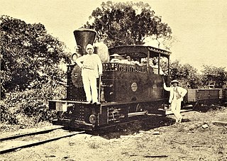
The Compagnie du chemin de fer du Congo supérieur aux Grands Lacs africains was a Belgian railway company established in 1902 in the Congo Free State, later the Belgian Congo, now the Democratic Republic of the Congo. It provided service in the eastern part of the colony south of Stanleyville (Kisangani) to serve the settlers and mining operations in Katanga. It operated a combination of river steamer service along the Lualaba River and railway links where the river was not navigable, including a link to Lake Tanganyika. In 1960 it became the Société congolaise des chemins de fer des Grands Lacs.

The Momboyo River is a river in the Democratic Republic of the Congo. It joins the Busira River to form the Ruki River, a tributary of the Congo River. The Momboya and its main tributary the Luilaka are navigable for 545 kilometres (339 mi) from its mouth.
The Lomela River is a river in the Democratic Republic of the Congo. It is one of the main tributaries of the Busira River, which forms where the Lomela meets the Tshuapa River. The Busira is in turn the main tributary of the Ruki River, which enters the Congo River to the north of Mbandaka.
The Salonga River is a river in the Democratic Republic of the Congo. It is a tributary of the Busira River.
Bokote is a community on the Busira River in the Province of Équateur in the Democratic Republic of the Congo. In the colonial period it held a trading post and a Catholic mission.
Lotoko is a community on the Busira River in the Province of Équateur in the Democratic Republic of the Congo. In the colonial period it held a trading post.
Monieka is a community on the Busira River in the Province of Équateur in the Democratic Republic of the Congo. In the colonial period it held a trading post and a Protestant mission.
Bomputu is a community on the Salonga River in the province of Tshuapa in the Democratic Republic of the Congo. In the colonial period it held a trading post.
This page is based on this
Wikipedia article Text is available under the
CC BY-SA 4.0 license; additional terms may apply.
Images, videos and audio are available under their respective licenses.
