This article needs additional citations for verification .(August 2008) |
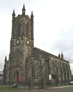
Ellesmere Park is an area of Eccles, in Greater Manchester, England. Historically part of Lancashire, Ellesmere Park today is an affluent, predominantly residential area.
This article needs additional citations for verification .(August 2008) |
Ellesmere Park is an area of Eccles, in Greater Manchester, England. Historically part of Lancashire, Ellesmere Park today is an affluent, predominantly residential area.
Ellesmere Park grew up around the turn of the 20th century. Contemporary views show pleasant, tree-lined roads, protected from the outside world by gates at the main entrances.
Ellesmere Park is an area of approximately 110 acres (45 ha) containing 450–500 properties. About 33% of the housing stock is Victorian, mainly large 2- to 3-storey detached or semi-detached houses/villas, usually standing in extensive grounds.
Salford Council maintains a design guide for Ellesmere Park. [1] The policy was prepared "in response to the decline in the environmental quality of Ellesmere Park which has taken place over recent years".
Inter war (1918–1939) and post war (1945 onwards) housing is also well represented in Ellesmere Park.
The developments of the late 19th and early 20th centuries give the area its characteristic spaciousness and grandeur. The houses are generally of generous (large) proportions and set in large grounds with large separations between them.
There is a strong residents association that works with the local council to ensure that any development is consistent with the character of the area and that the design policy is closely followed.
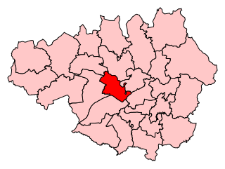
Ellesmere Park was administered by the municipal borough of Eccles until 1974, when the Local Government Act 1972 abolished the borough and it became a part of the metropolitan borough of City of Salford in Greater Manchester.

Greater Manchester is a metropolitan county and combined authority area in North West England, with a population of 2.8 million; comprising ten metropolitan boroughs: Manchester, Salford, Bolton, Bury, Oldham, Rochdale, Stockport, Tameside, Trafford and Wigan. The county was created on 1 April 1974, as a result of the Local Government Act 1972, and designated a functional city region on 1 April 2011. Greater Manchester is formed of parts of the historic counties of Lancashire, Cheshire and the West Riding of Yorkshire.

Salford is a city and the core settlement of the wider City of Salford metropolitan borough in Greater Manchester, England. In 2011, Salford had a population of 103,886. It is also the second and only other city in the county after neighbouring Manchester. Salford is located in a meander of the River Irwell which forms part of its boundary with Manchester. The former County Borough of Salford, which also included Broughton, Pendleton and Kersal, was granted city status in 1926. In 1974 the wider Metropolitan Borough of the City of Salford was established with responsibility for a significantly larger region.

Irlam is a suburb in the City of Salford, Greater Manchester, England. In 2011, it had a population of 19,933. It lies on flat ground on the south side of the M62 motorway and the north bank of the Manchester Ship Canal, 6.7 miles (10.8 km) southwest of Salford, 7.6 miles (12.2 km) southwest of Manchester and 8.3 miles (13.4 km) northeast of Warrington. Irlam forms a continuous urban area with Cadishead to the southwest, and is divided from Flixton and the Metropolitan Borough of Trafford to the southeast by the Manchester Ship Canal. The main road through Irlam, linking it to Cadishead and Eccles, is the A57. Irlam railway station also serves the district.

The City of Salford is a metropolitan borough with the status of a city in Greater Manchester, England. The borough is named after its main settlement, Salford. The borough covers the towns of Eccles, Swinton, Walkden and Pendlebury. As well as the villages and suburbs of Monton, Little Hulton, Boothstown, Ellenbrook, Clifton, Cadishead, Pendleton, Winton and Worsley. The city has a population of 245,600, and is administered from the Salford Civic Centre in Swinton. Salford is the historic centre of the Salford Hundred which was never formally ceased as a division of Lancashire.

Worsley is a village in the City of Salford in Greater Manchester, England, which in 2014 had a population of 10,090. It lies along Worsley Brook, 5.75 miles (9.25 km) west of Manchester.

Pendlebury is a town in the City of Salford, Greater Manchester, England. The population at the 2011 Census was 13,069. It lies 4.1 miles (6.6 km) northwest of Manchester city centre, 3.4 miles (5.5 km) northwest of Salford, and 5.9 miles (9.5 km) southeast of Bolton.

Eccles is a town in the City of Salford in Greater Manchester, England. Eccles is 2.7 miles (4.3 km) west of Salford and 3.7 miles (6.0 km) west of Manchester, split by the M602 motorway and bordered by the Manchester Ship Canal to the south. The town is famous for the Eccles cake.

Salford was a borough constituency represented in the House of Commons of the Parliament of the United Kingdom. It elected one Member of Parliament (MP) by the first past the post system of election. The borough constituency dated from 1997 and was abolished in 2010, replaced by Salford and Eccles.

Swinton is a town in the City of Salford in Greater Manchester, England. southwest of the River Irwell, 4.2 miles (6.8 km) northwest of Manchester city centre, adjoining the town of Pendlebury and suburb of Clifton. In 2014, it had a population of 22,931.

Broughton is a suburb and district of Salford, City of Salford, Greater Manchester, England, on the east bank of the River Irwell, it is 1 mile (1.6 km) northwest of Manchester and 2 miles (3.2 km) south of Prestwich.
Pendleton is a suburb and district of Salford, in the City of Salford, Greater Manchester, England, located 2 miles (3.2 km) from Manchester. The A6 dual carriageway skirts the east of the district. Historically in Lancashire, Pendleton experienced rapid urbanisation during the Industrial Revolution.

Blackley and Broughton is a constituency represented in the House of Commons of the UK Parliament by Graham Stringer. He was first elected in 1997 for the former Manchester Blackley and prior to this was Leader of Manchester City Council. The constituency covers north Manchester and east Salford.
Salford and Eccles is a constituency represented in the House of Commons of the UK Parliament since 2015 by Rebecca Long-Bailey, a member of the Labour Party.
Seedley is an inner city suburb of City of Salford, Greater Manchester, England.
Walkden is a town in the City of Salford in Greater Manchester, England, six miles northwest of Salford, and seven miles of Manchester.

Little Hulton is an area in the City of Salford, Greater Manchester, England, 3.4 miles (5.5 km) south of Bolton, 7 miles (11.3 km) northwest of Salford, and 9 miles (14.5 km) northwest of Manchester. Within the boundaries of the historic county of Lancashire, Little Hulton is bordered by Farnworth to the north, Walkden to the east and Tyldesley to the south.

Sholver is an area of Oldham, in Greater Manchester, England. An elevated, residential area, it lies near the middle of the Oldham part of the valley of the River Beal, 2.1 miles (3.4 km) northeast of Oldham's commercial centre, nearly at the northeasternmost extremity of the town, by open countryside close to the source of the River Medlock and by the border with Saddleworth.
The Tyldesley Loopline was part of the London and North Western Railway's Manchester and Wigan Railway line from Eccles to the junction west of Tyldesley station and its continuance south west via Bedford Leigh to Kenyon Junction on the Liverpool and Manchester Railway. The line opened on 1 September 1864 with stations at Worsley, Ellenbrook, Tyldesley, Leigh and Pennington before joining the Liverpool and Manchester Railway at Kenyon Junction.

The Trafford Centre is a tram stop built for Greater Manchester's Metrolink light rail system, built to serve passengers boarding and alighting at the Trafford Centre on the Trafford Park Line. Previously known as intu Trafford Centre, the tram terminus received the name The Trafford Centre after intu ceased ownership of the shopping centre, the tram stop's namesake. The stop is located adjacent to Barton Dock Road between Ellesmere Circle and Bright Circle.
Ellesmere Park High School is a coeducational secondary school located in the Ellesmere Park area of Eccles, Greater Manchester, England.