
Elliniko is a coastal municipality in the Attica region and a southern suburban town in the Athens agglomeration, Greece. Since the 2011 local government reform, it is part of the municipality Elliniko-Argyroupoli, of which it is a municipal unit. Elliniko is known for the former Hellinikon Olympic Complex, a temporary sporting complex building on the grounds of the former Ellinikon International Airport used for the 2004 Summer Olympics and the 2004 Summer Paralympics.
Trikolonoi is a former municipality in Arcadia, Peloponnese, Greece. Since the 2011 local government reform it is part of the municipality Gortynia, of which it is a municipal unit. The municipal unit has an area of 102.031 km2. The municipal unit includes the villages of Stemnitsa, Syrna, Pavlia, Palamari, Psari, Ano Kalyvia and Elliniko. Trikolonoi is located southeast of Dimitsana, west of Tripoli and north of Megalopoli. In 2011 Trikolonoi had a population of 578. The place takes its name from the ancient town of Tricoloni.

Evrostina is a village and a former municipality in Corinthia, Peloponnese, Greece. Since the 2011 local government reform it is part of the municipality Xylokastro-Evrostina, of which it is a municipal unit. The municipal unit has an area of 101.415 km2. The seat of administration of the former municipality was the town Derveni.
Farres is a former municipality in Achaea, West Greece, Greece. Since the 2011 local government reform, it is part of the municipality Erymanthos, of which it is a municipal unit. The municipal unit has an area of 241.848 km2. The municipality of Farres existed between 1835 and 1912, and again between 1998 and 2011. Its seat of administration was in the town Chalandritsa. Farres is situated in the centre of Achaea, on the upper courses of the rivers Peiros and Parapeiros. Towards the southeast and northeast (Panachaiko) the terrain is increasingly mountainous. It is located about 15 km south of Patras and 30 km west of Kalavryta. The Greek National Road 33 runs through western Farres.

Gortyna, is a former municipality in Arcadia, Peloponnese, Greece. Since the 2011 local government reform it is part of the municipality Megalopoli, of which it is a municipal unit. The municipal unit has an area of 116.205 km2. Its seat was in the village Karytaina. The name of the municipality was taken from the ancient city of Gortys.
Argyroupoli is a town and a suburb in the southern part of the Athens agglomeration, Greece. Since the 2011 local government reform it is part of the Elliniko-Argyroupoli municipality, of which it is the seat and a municipal unit. A bustling suburb today, it's known for its cafés, restaurants and bars.

Alimos is a town on the Saronic Gulf coast, a suburb of the Athens agglomeration, and a municipality in South Athens regional unit, Greece. It was formed in 1968 comprising two settlements, the suburban seaside town of Kalamaki, and the inland community of Trachones. Alimos had 41,720 inhabitants in the 2011 census.
Georgioupoli is a resort village and former municipality in the Chania regional unit, Crete, Greece. Since the 2011 local government reform it is part of the municipality Apokoronas, of which it is a municipal unit. The municipal unit has an area of 53.498 km2 (20.656 sq mi). It is located 39 kilometres east of Chania, about 23 km (14 mi) west of Rethymno and about 100 km (62 mi) west of Heraklio. It was named after Prince George of Greece, high commissioner of the island in the last years of Ottoman occupation.

Voula is a southern suburb of Athens along the Athens coast and former municipality in East Attica, Greece. Since the 2011 local government reform it is part of the municipality Vari-Voula-Vouliagmeni, of which it is the seat and a municipal unit. The municipal unit has an area of 8.787 km2. Grigoris Konstantellos is the incumbent mayor, elected for a second term at May 26, 2019, for the unified municipality of Vari-Voula-Vouliagmeni.

Vouliagmenis Avenue is one of the longest avenues in the Greater Athens area, stretching from central Athens to the seaside resort of Vouliagmeni. The total length is 21 km. The avenue begins at Athanasios Diakos Street and Michalakopoulou Street and the southbound portion of the avenue runs with three lanes to the southern portion of municipality of Athens and eastern Dafni. Seven Athens Metro subway stations lie underneath or next to the avenue: Agios Ioannis, Dafni, Agios Dimitrios, Ilioupoli station, Alimos station, Argyroupoli station and Elliniko station, all part of the southern section of the Red Line. It has an intersection with the road linking with the Hymettus Ring of the Attiki Odos motorway and Katechaki Avenue. It also has several intersections in Glyfada and with the Vari-Koropi Avenue.
Temenos is a former municipality in the Heraklion Regional Unit, Crete, Greece. Since the 2011 local government reform it is part of the municipality Heraklion, of which it is a municipal unit. The municipal unit has an area of 56.608 km2. Population 3,260 (2011). The seat of the municipality was in Profitis Ilias.

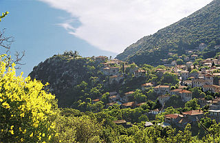
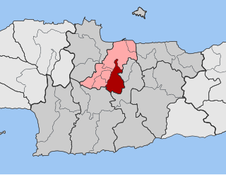
Lappa is a former municipality in the Rethymno regional unit, Crete, Greece. Since the 2011 local government reform it is part of the municipality Rethymno, of which it is a municipal unit. The municipal unit has an area of 51.132 km2 (19.742 sq mi). Population 2,216 (2011). The seat of the municipality was in Episkopi. The municipality's name was a revival of the name of the ancient city of Lappa, now the village of Argyroupoli.

Salamina or Kοullοuri is the largest city and a former municipality on Salamina Island in Greece. Since the 2011 local government reform it is part of the municipality of Salamina, of which it is the seat and a municipal unit.

Gortynia is a municipality in the Arcadia regional unit, Peloponnese, Greece. The seat of the municipality is the town Dimitsana. The municipality has an area of 1,050.882 km2.

South Athens is one of the regional units of Greece. It is part of the region of Attica. The regional unit covers the south-central part of the Athens agglomeration.

Spata-Artemida is a municipality in the East Attica regional unit, Attica, Greece. The seat of the municipality is the town Spata. The municipality has an area of 73.695 km2.

The Hellenic Air Accident Investigation and Aviation Safety Board is the air accident investigation agency of Greece.

The Municipality of Rethymno is a municipality in the Rethymno of the region of Crete established by Kallikratis reform. It consists of the unification of the pre-existing municipalities Arkadi, Lappa, Rethymno and Nikiforos Fokas of Rethymno Prefecture. The extent of the new municipality is 396.256 km2 (152.995 sq mi), and it had a population of 55,525 inhabitants at the 2011 census. The seat of the new municipality is the town Rethymno.
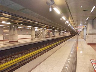
Elliniko is the current southern terminus on Athens Metro Line 2 since the Elliniko extension opened on 26 July 2013. With the opening of the station, travel time from Elliniko to Syntagma Square was reduced from 45 minutes to 20 minutes.
Velvina is a village and a community in the municipal unit of Nafpaktos in Nafpaktia, Aetolia-Acarnania, Greece. According to the 2011 census, it had 57 inhabitants.


