Marathon is a town in Greece and the site of the Battle of Marathon in 490 BCE, in which the heavily outnumbered Athenian army defeated the Persians. Legend has it that Pheidippides, a Greek herald at the battle, was sent running from Marathon to Athens to announce the victory, which is how the marathon running race was conceived in modern times. Today it is part of East Attica regional unit, in the outskirts of Athens and a popular resort town and center of agriculture.

Vari is a southern suburb of Athens and former municipality in East Attica, Greece along the Athens coast. The ancient Athenian deme of Anagyrous was situated here.

Lavrio, Lavrion or Laurium is a town in southeastern part of Attica, Greece. It is part of Athens metropolitan area and the seat of the municipality of Lavreotiki. Laurium was famous in Classical antiquity for its silver mines, which was one of the chief sources of revenue of the Athenian state. The metallic silver was mainly used for coinage. The Archaeological Museum of Lavrion shows much of the story of these mines.

Attica, or the Attic Peninsula, is a historical region that encompasses the entire Athens metropolitan area, which consists of the city of Athens, the capital of Greece and the core city of the metropolitan area, as well as its surrounding suburban cities and towns. It is a peninsula projecting into the Aegean Sea, bordering on Boeotia to the north and Megaris to the west. The southern tip of the peninsula, known as Laurion, was an important mining region.

Anavyssos is a town and a former municipality in East Attica, Greece located in the Athens Riviera. Since the 2011 local government reform it is part of the municipality Saronikos, of which it is a municipal unit. The municipal unit has an area of 14.478 km2. At the 2021 census it had 6,180 inhabitants.

Pyrgos is a city in the northwestern Peloponnese, Greece, capital of the regional unit of Elis and the seat of the Municipality of Pyrgos. The city is located in the middle of a plain, 4 kilometres from the Ionian Sea. The river Alfeios flows into sea about 7 km (4 mi) south of Pyrgos. The population of the town Pyrgos is 26,052, and of the municipality 45,365 (2021). Pyrgos is 16 km (10 mi) west of Olympia, 16 km (10 mi) southeast of Amaliada, 70 km (43 mi) southwest of Patras and 85 km (53 mi) west of Tripoli.

Larissos is a former municipality in Achaea, West Greece, Greece. Since the 2011 local government reform it is part of the municipality West Achaea, of which it is a municipal unit. The municipal unit has an area of 225.729 km2. Its seat of administration was in the village Lappas, part of the community Metochi. The municipal unit was named after the river Larissos, which flows through it. It is the westernmost municipal unit of Achaea, stretching along the Ionian Sea coast and the border with Elis to the southern part of the Movri hills. It is about 32 km southwest of Patras and 50 km north of Pyrgos.
Alifeira is a mountain village and a former municipality in Elis, West Greece, Greece. Since the 2011 local government reform it is part of the municipality Andritsaina-Krestena, of which it is a municipal unit. The municipal unit has an area of 96.678 km2. The seat of the municipality was in the village of Kallithea.
Troezen is a small town and a former municipality in the northeastern Peloponnese, Greece, on the Argolid Peninsula. Since the 2011 local government reform it is part of the municipality Troizinia-Methana, of which it is a municipal unit. It is part of the Islands regional unit. Population 4,668 (2021).
Drosia is a town in the East Attica regional unit and a suburb of the Athens agglomeration, Attica, Greece. Since the 2011 local government reform it is part of the municipality Dionysos, of which it is a municipal unit.

Artemida is an Eastern suburb of Athens. Since the 2011 local government reform it is part of the municipality Spata-Artemida, of which it is a municipal unit. The municipal unit has an area of 18.653 km2.

Palaia Fokaia is a former community and a seaside town in East Attica, Greece. Since the 2011 local government reform it is part of the municipality Saronikos, of which it is a municipal unit. The municipal unit has an area of 22.944 km2. Its population was 3,025 at the 2021 census.

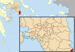
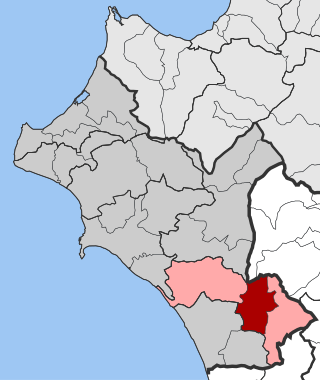
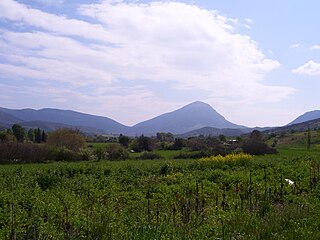
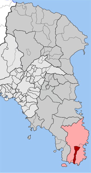
Keratea is a town in East Attica, Greece. Since the 2011 local government reform it is part of the municipality Lavreotiki, of which it is a municipal unit. The municipal unit has an area of 129.864 km2. It is part of Athens metropolitan area.
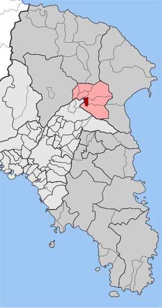
Agios Konstantinos is a village and a former community in East Attica, Greece. Since the 2011 local government reform it is part of the municipality Lavreotiki, of which it is a municipal unit. It was named after Saint Constantine.

Vilia is a village and a former municipality of West Attica, Greece. Since the 2011 local government reform it is part of the municipality Mandra-Eidyllia, of which it is a municipal unit. Its population was 2,514 at the 2021 census. It is part of Athens metropolitan area. The inhabitants of Vilia are Arvanites.

Kleitoria is a village and a municipal unit in Achaea, Peloponnese, Greece. It was also the new name of the former municipality Lefkasio, of which it was the seat, between 2008 and 2011. Since the 2011 local government reform it is part of the municipality Kalavryta, and became a municipal unit of this municipality. The municipal unit has an area of 253.221 km2. The site of the ancient city of Cleitor is nearby.
Milies is a village and a former municipality in Magnesia, Thessaly, Greece. Since the 2011 local government reform it is part of the municipality South Pelion, of which it is a municipal unit. The municipal unit has an area of 63.754 km2. It is a traditional Greek mountain village, at a height of 400 m on Mount Pelion. It is 28 km from Volos, the capital city of Magnesia. Milies is connected with the GR-34A It has traditional stone houses, cobbled roads, good restaurants and accommodation in abundance. Milies is also notable for being the terminus of the narrow gauge (60 cm) Pelion Railway, built between 1895 and 1903 by the Italian engineer, Evaristo de Chirico, father of the famous artist Giorgio de Chirico. This proved to be of considerable economic advantage to the region. The recently railway runs between Ano Lechonia and Milies twice a week at the weekend. The village commands striking views across the Pagasetic Gulf and benefits from the many streams and water sources for which Mt. Pelion is renowned. These result in rich vegetation and cool, forested mountain slopes.

Olenia is a former municipality in Achaea, West Greece, Greece. Since the 2011 local government reform it is part of the municipality West Achaea, of which it is a municipal unit. The municipal unit has an area of 189.534 km2. Population 4,303 (2021). The seat of the municipality was in Lousika. The municipality is named after the ancient Achaean town Olenus.

Nikaia-Agios Ioannis Renti is a municipality in the Piraeus regional unit, Attica, Greece. The seat of the municipality is the town Nikaia. The municipality has an area of 11.173 km2.

The Municipality of Rethymno is a municipality in the Rethymno of the region of Crete established by Kallikratis reform. It consists of the unification of the pre-existing municipalities Arkadi, Lappa, Rethymno and Nikiforos Fokas of Rethymno Prefecture. The extent of the new municipality is 396.256 km2 (152.995 sq mi), and it had a population of 57,216 inhabitants at the 2021 census. The seat of the new municipality is the town Rethymno.