The Au Sable River in Michigan, United States runs approximately 138 miles (222 km) through the northern Lower Peninsula, through the towns of Grayling and Mio, and enters Lake Huron at Au Sable. It is considered one of the best brown trout fisheries east of the Rockies and has been designated a blue ribbon trout stream by the Michigan Department of Natural Resources. In French, au sable literally means "at the sand." A 1795 map calls it the Beauais River.

The Zumbro River is a tributary of the Mississippi River in the Driftless Area of southeastern Minnesota in the United States. It is 64.6 miles (104.0 km) long from the confluence of its principal tributaries and drains a watershed of 1,428 square miles (3,700 km2). The river's name in English is a change from its French name Rivière des Embarras due to its mouth located near Pine Island in the Mississippi River; the Dakota name for this river is Wapka Wazi Oju, having reference to the grove of great white pines at Pine Island.

The Cobb River and its tributary the Little Cobb River are small rivers in southern Minnesota in the United States. The Cobb River is a 78.6-mile-long (126.5 km) tributary of the Le Sueur River. Via the Le Sueur, Blue Earth and Minnesota rivers, it is part of the watershed of the Mississippi River.

The Maple River is an 80.3-mile-long (129.2 km) tributary of the Le Sueur River in southern Minnesota in the United States. Via the Le Sueur, Blue Earth and Minnesota rivers, it is part of the watershed of the Mississippi River.
The Estrella River is a 28.5-mile-long (45.9 km) tributary river in eastern San Luis Obispo County, California. The river forms at the confluence of Cholame Creek, from the north, and San Juan Creek, from the south, near the town of Shandon. From there it flows west-northwest to its confluence with the Salinas River, of which it is a tributary, 8 miles north of Paso Robles. Cholame Creek has its headwaters on the southwest side of Middle Mountain and its tributary, Little Cholame Creek, begins on the northeast side. The creek drains the Cholame Valley, which is bordered by Diablo Range on the east and Cholame Hills, a northern extension of the Temblor Range, on the west. The average precipitation in the area ranges from 11 to 17 inches, increasing northward.
The Yellow Bank River is a 12.0-mile-long (19.3 km) tributary of the Minnesota River in western Minnesota in the United States. It is formed by the confluence of two longer streams, the North Fork Yellow Bank River and the South Fork Yellow Bank River, which also flow in northeastern South Dakota. Via the Minnesota River, the Yellow Bank River is part of the watershed of the Mississippi River, draining an area of approximately 460 square miles (1,190 km²) in an agricultural region.

The Ocqueoc River is stream in Presque Isle County in the northeastern part of the lower peninsula in the U.S. state of Michigan. It is 34.2 miles (55.0 km) long and encompasses a watershed of approximately 94,394 acres (382.00 km2).
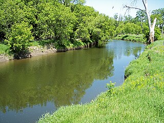
Ashley Creek is a 28.3-mile-long (45.5 km) tributary of the Sauk River in central Minnesota, United States, joining the Sauk just north of Sauk Centre. It is part of the Mississippi River watershed.
The Battle River is a 2.7-mile-long (4.3 km) tributary of Red Lake in Minnesota, the United States. It is formed by the junction of its North and South branches. The North Branch flows east to west for 13.7 miles (22.0 km) entirely in Beltrami County, and the South Branch flows 40.1 miles (64.5 km), starting at the outlet of Bartlett Lake in Koochiching County and flowing west-northwest into Beltrami County.
Buffalo Creek is an 84.3-mile-long (135.7 km) river in central Minnesota. It is a tributary of the South Fork of the Crow River, which is a tributary of the Mississippi River.
Crooked Creek is a 9.9-mile-long (15.9 km) tributary of the Mississippi River in northwestern Minnesota.
Hawk Creek is a 62.0-mile-long (99.8 km) tributary of the Minnesota River in Kandiyohi, Chippewa, and Renville counties, Minnesota, United States. It begins at the outlet of Foot Lake in Willmar and flows southwest, passing the cities of Raymond, Clara City, and Maynard. Turning south, it reaches the Minnesota River 7 miles (11 km) southeast of Granite Falls.
High Island Creek is a 69.4-mile-long (111.7 km) tributary of the Minnesota River in Minnesota. It rises as Judicial Ditch No. 11 in eastern Renville County, 6 miles (10 km) south of the city of Hector, and flows east into Sibley County, then McLeod County, then back into Sibley County, where it passes the city of Arlington before entering the Minnesota River 3 miles (5 km) north of Henderson.
Perch Creek is a 37.3-mile-long (60.0 km) tributary of the Watonwan River in southern Minnesota, United States. Via the Watonwan, Blue Earth, and Minnesota rivers, it is part of the Mississippi River watershed.
Sand Creek is a 36.6-mile-long (58.9 km) tributary of the Minnesota River in Le Sueur and Scott counties, Minnesota, United States. It rises at the outlet of Lake Sanborn, 2 miles (3 km) northeast of the city of Montgomery, and flows north past New Prague, entering the Minnesota River just north of Jordan.
The Sawbill Creek is a 4.7-mile-long (7.6 km) stream in northeastern Minnesota, the United States. It rises at the outlet of Sawbill Lake and is a tributary of the Temperance River.
Sleepy Eye Creek is a 51.8-mile-long (83.4 km) tributary of the Cottonwood River of Minnesota, the United States. Via the Cottonwood River, its water flows to the Minnesota River and eventually the Mississippi River.
Wells Creek is a 27.6-mile-long (44.4 km) tributary of the Mississippi River in Wabasha and Goodhue counties in Minnesota, United States. It enters the Mississippi at Old Frontenac.
Morgan Creek is a stream in Blue Earth County, Minnesota and Brown County, Minnesota, in the United States. It is a tributary of the Minnesota River.