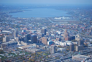
Downtown Syracuse is the economic center of Syracuse, New York, and Central New York, employing over 30,000 people, and housing over 4,300.

Westcott is a neighborhood in Syracuse, New York, United States. Its proximity to Syracuse University makes for a diverse community, home to Syracuse University students, professors and other faculty and staff, as well as residents at all income levels. Westcott Street is the main retail street of the neighborhood, featuring numerous restaurants, coffee shops, stores and The Westcott Theater performing arts venue. It is the site of the annual Westcott Street Cultural Fair, a one-day event with food, art, live performances and cultural activities. Westcott is also home to Thornden Park, one of the largest parks in Syracuse. The Westcott neighborhood is the boyhood home of renowned banjoist Tony Trischka.

The University Neighborhood is one of Syracuse, New York's 26 officially recognized neighborhoods. It borders the neighborhoods of Westcott to the north, University Hill to the west, Outer Comstock to the southwest, Skytop to the south, and Meadowbrook to the east.

Eastwood is a neighborhood in the northeastern part of Syracuse, New York, located adjacent to East Syracuse, New York, United States.

Meadowbrook is a Syracuse, New York neighborhood, located in the southeastern corner of the city. It corresponds to Onondaga County Census Tract 46. It is named after Meadow Brook, which runs through it and into Butternut Creek.
Southside is one of the 26 official neighborhoods in Syracuse, New York.
The Northside is a neighborhood in the city of Syracuse, New York (USA) consisting of a residential area bordered by commercial corridors. As defined by Syracuse's "Tomorrow's Neighborhoods Today" planning system, the Northside is a large section of the city of Syracuse, covering almost four square miles. There are 16 census tracts, within which are 36 census blockgroups. Thus, there are many sub-regions that have developed with their own unique identities, such as the Near Northeast neighborhood, the Little Italy District and the Hawley-Green Historic District.

Westside is a Syracuse, New York neighborhood, directly west of Downtown Syracuse. It corresponds to Onondaga County Census Tracts 21 and 22. It is made up of three parts, near West side, far west side and the West side

Near Northeast is a Syracuse, New York neighborhood, located northeast of the city's downtown. It corresponds to Onondaga County Census Tract 15, 16, 23, and 24.

The Comstock Tract Buildings of Syracuse University are a set of buildings that were listed on the National Register of Historic Places in 1980.

Salt Springs is a Syracuse, New York neighborhood, located in the northeastern corner of the city. It corresponds to Onondaga County Census Tract xx.
Near Eastside is one of the 26 officially recognized neighborhoods of Syracuse, New York. It borders seven other Syracuse neighborhoods, with Downtown Syracuse to the west, Near Northeast, Lincoln Park, Syracuse, and Eastwood to the north, Salt Springs to the east, and University Hill and Westcott to the south.
Lakefront is one of the 26 officially recognized neighborhoods of Syracuse, New York. It borders five other Syracuse neighborhoods, with Washington Square and Near Northeast to the east, Downtown Syracuse to the southeast, and Westside and Far Westside to the south.
Sedgwick is one of the 26 officially recognized neighborhoods of Syracuse, New York, United States. It borders four other Syracuse neighborhoods, with Northside to the north and west, Near Northeast to the southwest, Lincoln Park to the south, and Eastwood to the east.
South Valley is a neighborhood on the South side of Syracuse, New York. It features Meachem Elementary School, Clary Middle School, Betts Branch library, Webster's Pond, and the Redmond family.

Washington Square is one of the 26 officially recognized neighborhoods of Syracuse, New York.

Bartram Village is a small neighborhood in Southwest Philadelphia, Pennsylvania, United States. It is located in the vicinity of South 56th Street and Lindbergh Boulevard.

The Browncroft Historic District is a national historic district located in the Browncroft neighborhood of Rochester, New York. The district contains 518 contributing buildings, two contributing sites, two contributing objects, and two contributing structures over 116 acres. It includes 417 residential properties constructed between 1914 and World War II.
University Hill is a neighborhood and business district in Syracuse, New York, located east and southeast of Downtown Syracuse, on one of the larger hills in Syracuse. The neighborhood is bounded on the west by Almond Street and Interstate 81. It continues east to Ostrom Avenue and Thornden Park, where it borders the Westcott and University neighborhoods. Interstate 690 currently serves as the neighborhood's northern boundary.
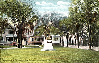
Columbus Square is a historic public square in the Historic Elmwood Neighborhood of Providence, Rhode Island. Located at the intersection of Elmwood Avenue and Reservoir Avenue, it serves as a gateway to Elmwood from the Reservoir and West End Neighborhoods.
