Cheyne Walk is a historic road in Chelsea, London, England, in the Royal Borough of Kensington and Chelsea. It runs parallel with the River Thames. Before the construction of Chelsea Embankment reduced the width of the Thames here, it fronted the river along its whole length.
Earl's Court is a district of Kensington in the Royal Borough of Kensington and Chelsea in West London, bordering the rail tracks of the West London line and District line that separate it from the ancient borough of Fulham to the west, the sub-districts of South Kensington to the east, Chelsea to the south and Kensington to the northeast. It lent its name to the now defunct eponymous pleasure grounds opened in 1887 followed by the pre–World War II Earls Court Exhibition Centre, as one of the country's largest indoor arenas and a popular concert venue, until its closure in 2014.

Kensington Palace is a royal residence set in Kensington Gardens, in the Royal Borough of Kensington and Chelsea in London, England. It has been a residence of the British royal family since the 17th century, and is currently the official London residence of the Prince and Princess of Wales, the Duke and Duchess of Gloucester, the Duke and Duchess of Kent, Prince and Princess Michael of Kent and Princess Eugenie and her husband Jack Brooksbank and their two sons. Kensington Palace is sometimes used as a metonym for the offices of royals who officially reside there.
Earl of Harrington is a title in the Peerage of Great Britain that was created in 1742.

William Conyngham Plunket, 1st Baron Plunket, PC (Ire), QC was an Irish politician and lawyer. After gaining public notoriety as the prosecutor in the treason trial of Robert Emmet in 1803, he rose rapidly in government service. He become Lord Chancellor of Ireland in 1830 and served, with a brief interruption, in that post until his retirement in 1841.

William Lee Plunket, 5th Baron Plunket was a British diplomat and administrator. He was Governor of New Zealand from 1904 to 1910.

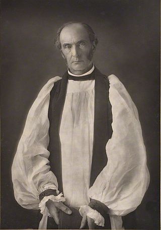
William Conyngham Plunket, 4th Baron Plunket was Dean of Christ Church Cathedral and Archbishop of Dublin in the Church of Ireland.

Carlton House Terrace is a street in the St James's district of the City of Westminster in London. Its principal architectural feature is a pair of terraces, the Western and Eastern terraces, of white stucco-faced houses on the south side of the street, which overlook The Mall and St. James's Park. These terraces were built on Crown land between 1827 and 1832 to overall designs by John Nash, but with detailed input by other architects including Decimus Burton. Construction was overseen by James Pennethorne. Both terrace blocks are Grade I listed buildings. A separate but linked cul-de-sac at the terrace's western end is named Carlton Gardens.

West Kensington, formerly North End, is an area in the ancient parish of Fulham, in the London Borough of Hammersmith and Fulham, England, 3.4 miles (5.5 km) west of Charing Cross. It covers most of the London postal area of W14, including the area around Barons Court tube station, and is defined as the area between Lillie Road and Hammersmith Road to the west, Fulham Palace Road to the south, Hammersmith to the north and West Brompton and Earl's Court to the east. The area is bisected by the major London artery the A4, locally known as the Talgarth Road. Its main local thoroughfare is the North End Road.

Hyde Park Gate is a street in Central London, England, which applies to two parallel roads in Kensington on the southern boundary of Kensington Gardens. These two roads run south, perpendicular to Kensington Road, but the name Hyde Park Gate also applies to the houses on the south side of that road between Queen's Gate and De Vere Gardens.

General Sir Patrick Leonard MacDougall, was a British Army officer who became Commander of the British Troops in Canada.

Tite Street is a street in Chelsea, London, England, within the Royal Borough of Kensington and Chelsea, just north of the River Thames. It was laid out from 1877 by the Metropolitan Board of Works, giving access to the Chelsea Embankment.

Little Holland House was the dower house of Holland House in the parish of Kensington, Middlesex, England. It was situated at the end of Nightingale Lane, now the back entrance to Holland Park and was demolished when Melbury Road was made. Number 14 Melbury Road marks its approximate location.

Onslow Square is a garden square in South Kensington, London, England.

Holland House, originally known as Cope Castle, was an early Jacobean country house in Kensington, London, situated in a country estate that is now Holland Park. It was built in 1605 by the diplomat Sir Walter Cope. The building later passed by marriage to Henry Rich, 1st Baron Kensington, 1st Earl of Holland, and by descent through the Rich family, then became the property of the Fox family, during which time it became a noted gathering-place for Whigs in the 19th century. The house was largely destroyed by German firebombing during the Blitz in 1940 and today only the east wing and some ruins of the ground floor and south facade remain, along with various outbuildings and formal gardens. In 1949 the ruin was designated a grade I listed building and it is now owned by the Royal Borough of Kensington and Chelsea.

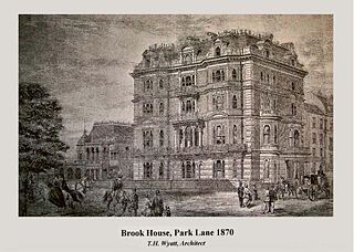
Brook House was a mansion and is now a block of flats in Mayfair, a prestigious and expensive district of central London. The building is located at 113 Park Lane and was constructed by Thomas Henry Wyatt from 1867 to 1869. It was the home of Edward VII's private banker Sir Ernest Cassel and his granddaughter, who became Edwina Mountbatten, Countess Mountbatten of Burma. Upon his death in 1921, she inherited it, and a decade later had it remodelled into flats. At the end of the 20th century the property was rebuilt once more.

Earls Terrace is a street in Kensington, London, W8. It has houses on one side only, a terrace of 25 Georgian houses, built in 1800–1810, all of which are Grade II listed. Numbers 1 and 25, at the ends of the terrace, are converted into flats.

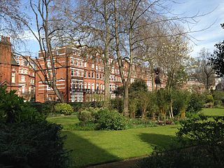
Egerton Gardens is a street and communal garden, regionally termed a garden square, in South Kensington, London SW3.

Hamilton Terrace is a wide, tree-lined residential thoroughfare in St John's Wood, London, England. It runs north to south from Carlton Hill to St. John's Wood Road, and is parallel to Maida Vale to the west.

Ovington Square is a garden square in central London's Knightsbridge district. It lies between Brompton Road to the north-west and Walton Street to the south-east.


