
Dunstanburgh Castle is a 14th-century fortification on the coast of Northumberland in northern England, between the villages of Craster and Embleton. The castle was built by Earl Thomas of Lancaster between 1313 and 1322, taking advantage of the site's natural defences and the existing earthworks of an Iron Age fort. Thomas was a leader of a baronial faction opposed to King Edward II, and probably intended Dunstanburgh to act as a secure refuge, should the political situation in southern England deteriorate. The castle also served as a statement of the earl's wealth and influence and would have invited comparisons with the neighbouring royal castle of Bamburgh. Thomas probably only visited his new castle once, before being captured at the Battle of Boroughbridge as he attempted to flee royal forces for the safety of Dunstanburgh. Thomas was executed, and the castle became the property of the Crown before passing into the Duchy of Lancaster.

Craster is a small fishing village on the Northumberland coast of England, eight miles (13 km) from Alnwick. The next village to the north is Embleton.
Embleton is a village and civil parish in the English county of Northumberland. Besides the village of Embleton itself, the civil parish includes the settlement of Christon Bank, situated about a mile to the west.
Alnwick is a market town in Northumberland, England, of which it is the traditional county town. The population at the 2011 Census was 8,116.
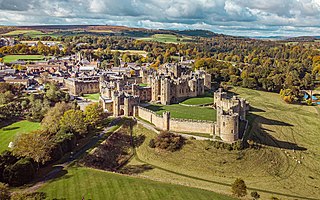
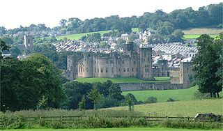
Alnwick Castle is a castle and country house in Alnwick in the English county of Northumberland. It is the seat of the 12th Duke of Northumberland, built following the Norman conquest and renovated and remodelled a number of times. It is a Grade I listed building now the home of Ralph Percy, 12th Duke of Northumberland and his family. In 2016, the castle received over 600,000 visitors per year when combined with adjacent attraction The Alnwick Garden.
Fallodon is a hamlet and former civil parish, now in the parish of Newton-by-the-Sea, in the county of Northumberland, England. It is the territorial designation of Viscount Grey of Fallodon and Baronet Grey of Fallodon. It is pronounced with the emphasis on the first syllable.

Brizlee Tower is a Grade 1 listed folly set atop a hill in Hulne Park, the walled home park of the Duke of Northumberland in Alnwick, Northumberland. The tower was erected in 1781 for Hugh Percy, 1st Duke of Northumberland, and commands extensive views over North Northumberland and the Borders.

George Johnston was a Scottish physician and naturalist.
Gilbert Rule was a nonconformist Church of Scotland minister and the Principal of Edinburgh University from 1690 to 1701.
Newton-by-the-Sea is a civil parish in the county of Northumberland in Northern England. The parish is about 8 miles northwest of Alnwick, and lies on the coast between the larger settlements of Embleton and Seahouses. Newton-by-the-Sea is in the parliamentary constituency of Berwick-upon-Tweed. The population of the parish in the 2011 United Kingdom Census was 212. The area of the parish is 15.82 square kilometres (6.11 sq mi)
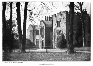
Embleton Tower is a peel tower and Grade I listed building in the village of Embleton in Northumberland, England. Tradition states that in 1395, the tower was built to protect the minister and church goers of Embleton's Church of the Holy Trinity after the village suffered from a raid by the Scots. The first vicarage was provided for the vicar of Embleton by Merton College, Oxford, who held the patronage of the parish, in 1332. According to Montagu Francis Finch Osborn (1843–1910), vicar of Embleton in 1884, vicarages were erected at three different periods; by 1416, the Vicar's Turris de Emyldon was known to exist. The present building includes a house built in about 1828 as a vicarage adjoining the tower.
The Battle of Piperdean was an engagement in the Scottish Borders, fought on 10 September 1435 between the Kingdom of Scotland and the Kingdom of England.

St Cuthbert's Church is located in Elsdon, Alnwick, northeast England. The church was one of the resting places of St. Cuthbert's body in the wanderings of the monks. It is one of the many dedicated to his memory. St Cuthbert's Church is a Grade I listed building in Northumberland.

The Church of St Michael in Alnham, in the English county of Northumberland, is a medieval structure dating from circa 1200. Built on a Roman camp site, it is mentioned in records dating to 1291; it is a Grade I listed building.
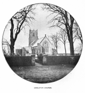
The Church of the Holy Trinity is located in Embleton, Northumberland, England. The church, dedicated to the Holy Trinity, is west of the village. Built in the form of a cross, it consists of a two aisle nave, a clerestory, a chancel, a porch, and a chantry chapel. It has a tower with a small vestry, and a gallery. The vicarage house and garden are on a gradual slope on the south side of the churchyard. Traces of stonework show evidence of an earlier church from the 12th century. It is a Grade I listed building.

The North Northumberland Coastal Plain is a major natural region that lies on England's northeasternmost stretch of coastline on the North Sea. To the west lie the Cheviot Fringe, the Northumberland Sandstone Hills and Mid Northumberland; to the south it is continued by the South East Northumberland Coastal Plain.

George Tate was an English tradesman from Northumberland, known as a local topographer, antiquarian and naturalist. His major work was a history of his native town, Alnwick.
Ratcheugh Observatory is a late 18th-century folly on a prominent crag between Alnwick and Longhoughton in north Northumberland, England. Commissioned by Hugh Percy, 1st Duke of Northumberland, the castellated Observatory incorporates a viewing tower with prospects of Alnwick and its castle, and of the North Sea coast at Boulmer.


