Emerald Canyon

Last updated
Emerald Canyon
Relief map of California.png
Red pog.svg
Location of Emerald Canyon in California
CountryUnited States
StateCalifornia
Physical characteristics
Source San Joaquin Hills
 - coordinates 33°35′34″N117°46′49″W / 33.59278°N 117.78028°W / 33.59278; -117.78028 [1]
 - elevation955 ft (291 m)
River mouth Pacific Ocean
 - locationEmerald Bay, Laguna Beach
 - coordinates 33°33′04″N117°48′28″W / 33.55111°N 117.80778°W / 33.55111; -117.80778 Coordinates: 33°33′04″N117°48′28″W / 33.55111°N 117.80778°W / 33.55111; -117.80778 [1]
 - elevation0 ft (0 m)
Length3.46 mi (5.57 km)

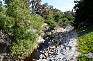
Emerald Canyon is a canyon and watercourse in Laguna Beach, Orange County, California, which drains a section of the San Joaquin Hills 1.5 miles (2.4 km) northwest of central Laguna Beach. Emerald Canyon Creek, about 3 miles (4.8 km) long, originates at the summit of the range near SR 73 (the San Joaquin Hills Toll Road) and flows southwest under the Pacific Coast Highway into Emerald Bay. [2]

Laguna Beach, California City in California, United States

Laguna Beach is a seaside resort city located in southern Orange County, California, in the United States. It is known for a mild year-round climate, scenic coves, environmental preservation, and an artist community. The population in the 2010 census was 22,723. As per population estimate in July 2017 the total population of Laguna Beach city was 23,174.

Orange County, California County in California, United States

Orange County is a county in the Los Angeles metropolitan area in the U.S. state of California. As of the 2010 census, the population was 3,010,232, making it the third-most populous county in California, the sixth-most populous in the United States, and more populous than 21 U.S. states. Its county seat is Santa Ana. It is the second most densely populated county in the state, behind San Francisco County. The county's four largest cities by population, Anaheim, Santa Ana, Irvine, and Huntington Beach, each have a population exceeding 200,000. Several of Orange County's cities are on the Pacific Ocean western coast, including Huntington Beach, Newport Beach, Laguna Beach, Dana Point, and San Clemente.

California State of the United States of America

California is a state in the Pacific Region of the United States. With 39.6 million residents, California is the most populous U.S. state and the third-largest by area. The state capital is Sacramento. The Greater Los Angeles Area and the San Francisco Bay Area are the nation's second and fifth most populous urban regions, with 18.7 million and 9.7 million residents respectively. Los Angeles is California's most populous city, and the country's second most populous, after New York City. California also has the nation's most populous county, Los Angeles County, and its largest county by area, San Bernardino County. The City and County of San Francisco is both the country's second-most densely populated major city after New York City and the fifth-most densely populated county, behind only four of the five New York City boroughs.

The canyon is located inside Laguna Coast Wilderness Park, and has trails for hiking and mountain biking. However, it is only accessible from the north (uphill) end, as the lower part terminates in private property. A point of interest in the canyon is the 20-foot (6.1 m) high Emerald Canyon Falls, which only flows after periods of heavy rain. [3]

Laguna Coast Wilderness Park

Laguna Coast Wilderness Park is a 7,000-acre (2,800 ha) wilderness area in the San Joaquin Hills surrounding Laguna Beach, California. This park features coastal canyons, ridgeline views and the only natural lakes in Orange County, California. Trails are maintained for hiking and mountain biking with a wide range of difficulty, from beginner to expert. Most trails gain in height, reaching a maximum of 1,000 feet (300 m) in elevation. Several trails lead to downtown Laguna Beach.

Emerald Canyon has been historically known as Mayate Canyon and Nigger Canyon. [1]

See also

Related Research Articles

Laguna Niguel, California City in California, United States

Laguna Niguel is a suburban city in Orange County, California in the United States. The name Laguna Niguel is derived from the words "Laguna" and "Niguili". As of the 2010 census, the population was 62,979. Laguna Niguel is located in the San Joaquin Hills in the southeastern corner of Orange County, close to the Pacific Ocean, and borders the cities of Aliso Viejo, Dana Point, Laguna Beach, Laguna Hills, Mission Viejo, and San Juan Capistrano.

Piru Creek river in the United States of America

Piru Creek is a major stream, about 71 miles (114 km) long, in northern Los Angeles County and eastern Ventura County, California. It is a tributary of the Santa Clara River, the largest stream system in Southern California that is still relatively natural.

San Joaquin Hills hill range in California

The San Joaquin Hills are a low mountain range of the Peninsular Ranges System, located in coastal Orange County, California.

San Juan Creek river in United States of America

San Juan Creek, also called the San Juan River, is a 29-mile (47 km) long stream in Orange County, California draining a watershed of 133.9 square miles (347 km2). Its mainstem begins in the southern Santa Ana Mountains in the Cleveland National Forest. It winds west and south through San Juan Canyon, and is joined by Arroyo Trabuco as it passes through San Juan Capistrano. It flows into the Pacific Ocean at Doheny State Beach. San Juan Canyon provides a major part of the route for California State Route 74.

Aliso Creek (Orange County) river in the United States of America

Aliso Creek is a 19.8-mile (31.9 km)-long, mostly urban stream in south Orange County, California. Originating in the Cleveland National Forest in the Santa Ana Mountains, it flows generally southwest and empties into the Pacific Ocean at Laguna Beach. The creek's watershed drains 34.9 square miles (90 km2), and it is joined by seven main tributaries. As of 2018, the watershed had a population of 144,000 divided among seven incorporated cities.

Oso Creek river in the United States of America

Oso Creek is an approximately 13.5-mile (21.7 km) tributary of Arroyo Trabuco in southern Orange County in the U.S. state of California. Draining about 20 square miles (52 km2) in a region north of the San Joaquin Hills and south of the Santa Ana Mountains, the creek is Trabuco Creek's largest tributary, and is part of the San Juan Creek drainage basin. Beginning in the foothills of the Santa Ana Mountains near the city of Mission Viejo, the creek is dammed twice to form Upper Oso Reservoir and Lake Mission Viejo. The creek is channelized and polluted along much of its length.

Arroyo Trabuco

Arroyo Trabuco is a 22-mile (35 km)-long stream in coastal southern California in the United States. Rising in a rugged canyon in the Santa Ana Mountains of Orange County, the creek flows west and southwest before emptying into San Juan Creek in the city of San Juan Capistrano. Arroyo Trabuco's watershed drains 54 square miles (140 km2) of hilly, semi-arid land and lies mostly in Orange County, with a small portion extending northward into Riverside County. The lower section of the creek flows through three incorporated cities and is moderately polluted by urban and agricultural runoff.

Aliso and Wood Canyons Wilderness Park

Aliso and Wood Canyons Wilderness Park is a major regional park in the San Joaquin Hills of Orange County, California in the United States. Comprising 4,500 acres (1,800 ha) of rugged coastal canyons, open grassland, and riparian woodland, the park borders the suburban cities of Aliso Viejo, Dana Point, Laguna Beach, Laguna Hills and Laguna Niguel.

Wood Canyon Creek river in the United States of America

Wood Canyon Creek is a 2.8 mi (4.5 km) perennial stream in Aliso and Wood Canyons Wilderness Park, Orange County, California. A tributary of Aliso Creek, it drains a deep undeveloped valley to the west of Aliso Viejo.

Laguna Canyon landform

Laguna Canyon is the name of a canyon that cuts through the San Joaquin Hills in southern Orange County, California, in the United States, directly south of the city of Irvine. The canyon runs from northeast to southwest, and is drained on the north side by tributaries of San Diego Creek and on the south by Laguna Canyon Creek. It is deeper and more rugged on the southwestern end near Laguna Beach.

San Diego Creek

San Diego Creek is a 16-mile (26 km) urban waterway flowing into Upper Newport Bay in Orange County, California in the United States. Its watershed covers 112.2 square miles (291 km2) in parts of eight cities, including Irvine, Tustin, and Costa Mesa. From its headwaters in Laguna Woods the creek flows northwest to its confluence with Peters Canyon Wash, where it turns abruptly southwest towards the bay. Most of the creek has been converted to a concrete flood control channel, but it also provides important aquatic and riparian habitat along its course and its tidal estuary.

Rancho San Joaquin, the combined Rancho Cienega de las Ranas and Rancho Bolsa de San Joaquin, was a 48,803-acre (197.50 km2) Mexican land grant in the San Joaquin Hills, within present-day Orange County, California.

Sulphur Creek (California)

Sulphur Creek is a 4.5-mile (7.2 km) tributary of Aliso Creek in Orange County in the U.S. state of California. The creek drains about 6 square miles (16 km2) of residential communities and parks in the southern San Joaquin Hills.

Coyote Creek (San Gabriel River tributary) stream in Southern California, tributary of the San Gabriel River

Coyote Creek is a principal tributary of the San Gabriel River in northwest Orange County, southeast Los Angeles County, and southwest Riverside County, California. It drains a land area of roughly 41.3 square miles (107 km2) covering five major cities, including Brea, Buena Park, Fullerton, La Habra, and La Palma. Some major tributaries of the creek in the highly urbanized watershed include Brea Creek, Fullerton Creek, and Carbon Creek. The mostly flat creek basin is separated by a series of low mountains, and is bounded by several small mountain ranges, including the Chino Hills, Puente Hills and West Coyote Hills.

Tijeras Canyon Creek river in the United States of America

Tijeras Canyon Creek is a watercourse in northeast Orange County, California and a tributary of Arroyo Trabuco. It originates in the foothills of the Santa Ana Mountains, and flows southwest through the suburban city of Rancho Santa Margarita for several miles as an underground culvert. Below State Route 241 it becomes a free-flowing creek, traveling through Cañada Vista Park and Tijeras Creek Golf Club before joining with Trabuco Creek in O'Neill Regional Park.

Sand Canyon Wash is an approximately 6.9-mile (11.1 km) tributary of San Diego Creek in Orange County, southern California.

Moro Canyon

Moro Canyon is a canyon and seasonal stream near Laguna Beach, Orange County, California in the Crystal Cove State Park. Moro Canyon Creek originates at the summit of the San Joaquin Hills and flows southwest, under Pacific Coast Highway to empty into the Pacific Ocean at Moro Beach.

Matilija Wilderness 29,207-acres of Los Padres National Forest in Southern California

The Matilija Wilderness is a 29,207-acre (11,820 ha) wilderness area in Ventura and Santa Barbara Counties, Southern California. It is managed by the U.S. Forest Service, being situated within the Ojai Ranger District of the Los Padres National Forest. It is located adjacent to the Dick Smith Wilderness to the northwest and the Sespe Wilderness to the northeast, although it is much smaller than either one. The Matilija Wilderness was established in 1992 in part to protect California condor habitat.

References

  1. 1 2 3 "Emerald Canyon". Geographic Names Information System . United States Geological Survey. 1981-01-19. Retrieved 2016-12-05.
  2. USGS Topo Maps for United States (Map). Cartography by United States Geological Survey. ACME Mapper. Retrieved 2016-12-05.
  3. Schad, Jerry (2006-05-18). "Emerald Canyon in Orange County's Laguna Coast Wilderness Park attracts hikers and mountain bikers". San Diego Reader. Retrieved 2016-12-05.