Castlemaine is a small city in Victoria, Australia, in the Goldfields region about 120 kilometres northwest by road from Melbourne and about 40 kilometres from the major provincial centre of Bendigo. It is the administrative and economic centre of the Shire of Mount Alexander. The population at the 2016 Census was 6,757. Castlemaine was named by the chief goldfield commissioner, Captain W. Wright, in honour of his Irish uncle, Viscount Castlemaine.

Box Hill South is a suburb of Melbourne, Victoria, Australia, 14 km east of Melbourne's Central Business District. Its local government area is the City of Whitehorse. At the 2016 Census, Box Hill South had a population of 8,434.

Cloncurry is a town and locality in the Shire of Cloncurry, Queensland, Australia. It is the administrative centre of the shire. At the 2016 census, Cloncurry recorded a population of 2,719 people.

Cunnamulla is a town and a locality in the Shire of Paroo, Queensland, Australia. It is 206 kilometres (128 mi) south of Charleville, and approximately 750 kilometres (470 mi) west of the state capital, Brisbane. In the 2016 census, Cunnamulla had a population of 1,140 people.

Euroa is a town in the Shire of Strathbogie in the north-east of Victoria, Australia. At the 2016 census, Euroa's population was 3,275.

Emu Park is a coastal town and locality on the Capricorn Coast located 21 kilometres (13 mi) south of Yeppoon in Queensland, Australia. It is within the local government area of Shire of Livingstone. In the 2016 census the locality of Emu Park had a population of 2,130 people.
Redland City, better known as the Redlands and formerly known as Redland Shire, is a local government area and a part of the Brisbane metropolitan area in South East Queensland. With a population of 156,863 in June 2018, the City is spread along the southern coast of Moreton Bay, covering 537.2 square kilometres (207.4 sq mi). Its mainland borders the City of Brisbane to the west and north-west, and Logan City to the south-west and south, while its islands are situated north of the City of Gold Coast.

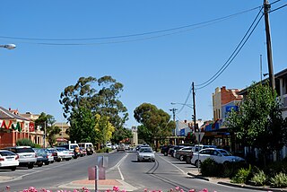
Tumut is a town in the Riverina region of New South Wales, Australia, situated on the banks of the Tumut River.
Kerang is a rural town on the Loddon River in northern Victoria in Australia. It is the commercial centre to an irrigation district based on livestock, horticulture, lucerne and grain. It is located 279 kilometres (173 mi) north-west of Melbourne on the Murray Valley Highway a few kilometres north of its intersection with the Loddon Valley Highway, elevation 78 metres (256 ft). At the 2016 census, Kerang had a population of 3,893. Kerang is believed to be an Aboriginal word for Cockatoo. It is home to the largest solar and battery farm in the country which was opened in June 2019. The 50-megawatt battery system is located outside of Kerang and stores 100 per cent renewable energy. The 2,000 solar panels have become a tourist attraction and are drawing many businesses to the town.

Morven is a town and a locality in the Shire of Murweh, Queensland, Australia. In the 2016 census, Morven had a population of 199 people.

Beveridge is a town in Victoria, Australia, located along the Hume Highway, 42 kilometres north of Melbourne. It is governed by the City of Whittlesea and Mitchell Shire. At the 2016 Census, Beveridge had a population of 2,330.

Monto is a rural town and locality in the North Burnett Region, Queensland, Australia. In the 2016 census, Monto had a population of 1,189 people.

Wollondilly Shire is a periurban local government area adjacent to the south-western fringe of Sydney, parts of which fall into the Macarthur, Blue Mountains and Central Tablelands regions in the state of New South Wales, Australia. Wollondilly Shire was created by proclamation in the NSW Government Gazette on 7 March 1906, following the passing of the Local Government (Shires) Act 1905, and amalgamated with the Municipality of Picton on 1 May 1940.

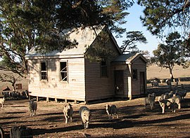
Bung Bong is a township in Victoria between the rural towns of Avoca and Maryborough. The township is divided, with the Western section in the Pyrenees Shire and the Eastern section in Shire of Central Goldfields. The Bet Bet Creek runs towards the north through the middle of the township and then into the Loddon River. Bung Bong is located on the Pyrenees Highway.

Linville is a rural town and locality in the Somerset Region, Queensland, Australia. In the 2016 census, Linville had a population of 156 people.

Crows Nest is a rural town and locality in the Toowoomba Region, Queensland, Australia. The town is located in the Darling Downs on the New England Highway, 158 kilometres (98 mi) from the state capital, Brisbane and 43 kilometres (27 mi) from the nearby city of Toowoomba. In the 2016 census, Crows Nest had a population of 2160 people.

Trawalla is a town in central Western Victoria, Australia, located on the Western Highway, 41 kilometres (25 mi) west of Ballarat and 154 kilometres (96 mi) west of Melbourne, in the Shire of Pyrenees. At the 2006 census, Trawalla and the surrounding agricultural area had a population of 224.

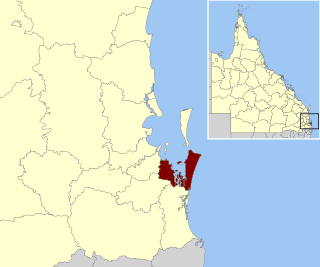
Mirani is a town and locality in Mackay Region, Queensland, Australia. In the 2016 census, Mirani had a population of 1,541 people.
Halifax is a town and a coastal locality in the Shire of Hinchinbrook, Queensland, Australia. In the 2016 census, Halifax had a population of 462 people.

Barrabool is a rural locality in the Surf Coast Shire, Victoria, Australia. In the 2016 census, Barrabool had a population of 235 people.