Related Research Articles

Downieville is a census-designated place in and the county seat of Sierra County, California, United States. Downieville is on the North Fork of the Yuba River, at an elevation of 2,966 feet (904 m). The 2010 United States census reported Downieville's population was 282.
The Gold Country is a historic region in the northern portion of the U.S. state of California, that is primarily on the western slope of the Sierra Nevada. It is famed for the mineral deposits and gold mines that attracted waves of immigrants, known as the 49ers, during the 1849 California Gold Rush.

State Route 49 is a north–south state highway in the U.S. state of California that passes through many historic mining communities of the 1849 California gold rush. Highway 49 is numbered after the "49ers", the waves of immigrants who swept into the area looking for gold, and it is known as the Golden Chain Highway. This roadway begins at Oakhurst, Madera County, in the Sierra Nevada, where it diverges from State Route 41. It continues in a generally northwest direction, weaving through the communities of Goldside and Ahwahnee, before crossing into Mariposa County. State Route 49 then continues northward through the counties of Tuolumne, Calaveras, Amador, El Dorado, Placer, Nevada, Yuba, Sierra, and Plumas, where it reaches its northern terminus at State Route 70, in Vinton.

South Yuba River State Park is located along the South Fork of the Yuba River in the Sierra Nevada, within Nevada County, in Northern California.

Washington is a census-designated place located in Nevada County, California. Washington is located on the banks of the South Fork of The Yuba River and has a population of approximately two hundred people. There is a hotel/bar and restaurant, grocery store, a one-room schoolhouse that has educated students continuously for one hundred years, and two trailer park campgrounds. The elevation is 2,612 feet (796 m). The population was 185 at the 2010 census.

The Yuba River is a tributary of the Feather River in the Sierra Nevada and eastern Sacramento Valley, in the U.S. state of California. The main stem of the river is about 40 miles (64 km) long, and its headwaters are split into three major forks. The Yuba River proper is formed at the confluence of the North Yuba and Middle Yuba Rivers, with the South Yuba joining a short distance downstream. Measured to the head of the North Yuba River, the Yuba River is just over 100 miles (160 km) long.
Charles Eamer Sexey was an English trader. He first visited New Zealand as a young man where he farmed and traded. In 1849 he travelled to San Francisco and took part in the Gold Rush as a trader in the mining camps. Eventually, having made his fortune out of the mining industry, he moved to Marysville, California, where he became a Levee Commissioner, landowner and President of the informal anti-mining activist group, the Anti-Debris Association, which was concerned with protecting landowner rights. He built some of the most important buildings in the city, one of which housed the Appeal newspaper, now known as the Appeal-Democrat.

The Bear River is a tributary of the Feather River in the Sierra Nevada, winding through four California counties: Yuba, Sutter, Placer, and Nevada. About 73 miles (117 km) long, the river flows generally southwest through the Sierra then west through the Central Valley, draining a narrow, rugged watershed of 295 square miles (760 km2).
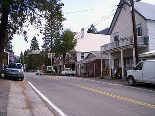
Sierra City is a census-designated place in Sierra County, California, United States. The elevation of Sierra City is 4,147 feet (1,264 m), and the town is situated in the canyon of the North Yuba River on California State Route 49, twelve miles northeast of the county seat of Sierra County, Downieville. The population was 221 at the 2010 census.

Bullards Bar is a former gold mining settlement in Yuba County, California.
Condemned Bar is a former settlement, in Yuba County, California.

The North Bloomfield Mining and Gravel Company of North Bloomfield, California, was established in 1866 and operated a hydraulic gold-mining operation at the Malakoff Mine subsequent to the California Gold Rush. In its day, no other company's operations matched North Bloomfield Mining and Gravel Company in size or expense. The company operated until 1910. In the years prior, its profits and procedures had been reduced due to the landmark ruling of Woodruff v. North Bloomfield Gravel Mining Company.
Landers Bar is a former mining settlement of the California Gold Rush, in Yuba County, California.
Malay Camp is a former settlement and mining camp in Yuba County, California, United States.
Cordua Bar is a former mining town of the California Gold Rush, located in Yuba County, California.
Cape Horn Bar is a former settlement and mining camp of the California Gold Rush, in Yuba County, California.
Bridgeport is a former settlement on the Yuba River in Nevada County, California, 2 mi (3.2 km) from the town of French Corral. Its elevation is 567 ft (173 m) above sea level.

The Middle Yuba River is one of the three main forks of the Yuba River in Northern California in the United States. The river rises at the crest of the Sierra Nevada, and flows generally west through canyons to join the North Yuba River near North San Juan. The confluence of the two rivers forms the main stem of the Yuba River, which then continues west to join the Feather River. The Middle Yuba forms much of the border between Nevada County and Sierra County and in its lower reaches a small segment of the Nevada–Yuba County line. The Middle Yuba drains a remote, rugged portion of the Tahoe National Forest, with elevations ranging from 8,373 ft (2,552 m) at English Mountain to 1,129 ft (344 m) at the confluence with the Yuba River.
Brass Wire Bar is a former settlement in Nevada County, California. Brass Wire Bar is located on the South Yuba River, across from Washington. It was a mining camp; Chinese miners worked the site in 1880. About $50,000 dollars worth of gold was found there.
The Independence Trail is located approximately 7 miles from downtown Nevada City within the South Yuba River State Park in the Sierra Nevada foothills within Nevada County, in Northern California. The trail is the former Excelsior Ditch, which was found and repaired by John Olmsted and a large group of local volunteers. It is notable for being the first ADA approved wheelchair nature trail. It topped the list of "favorite trails for 2013" in The Sacramento Bee newspaper.
References
- 1 2 Durham, David L. (1998). California's Geographic Names: A Gazetteer of Historic and Modern Names of the State. Clovis, Calif.: Word Dancer Press. p. 457. ISBN 1-884995-14-4.
Municipalities and communities of Yuba County, California, United States | ||
|---|---|---|
| Cities |  | |
| CDPs | ||
| Unincorporated communities | ||
| Ghost towns | ||
| Footnotes | ‡This populated place also has portions in an adjacent county or counties | |
| This Yuba County, California-related article is a stub. You can help Wikipedia by expanding it. |