North Yuba River

Last updated
North Yuba River
Historic American Buildings Survey Roger Sturtevant, Photographer Mar. 29, 1934 GENERAL VIEW FROM WEST - Downieville, General View, Downieville, Sierra County, CA HABS CAL,46-DOWNV,1-2.tif
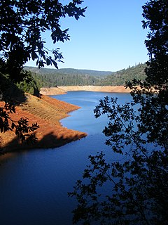
The North Yuba at Downieville, c. 1934
Yubamap-01.png
Map of the Yuba River watershed, including the North Yuba River
Location
Country United States
State California
Physical characteristics
Source Yuba Pass
 - locationNear State Route 49, Sierra Nevada
 - coordinates 39°37′03″N120°29′53″W / 39.61750°N 120.49806°W / 39.61750; -120.49806
 - elevation7,018 ft (2,139 m)
Mouth Yuba River
 - location
West of North San Juan, Yuba County
 - coordinates
39°22′07″N121°08′11″W / 39.36861°N 121.13639°W / 39.36861; -121.13639 Coordinates: 39°22′07″N121°08′11″W / 39.36861°N 121.13639°W / 39.36861; -121.13639
 - elevation
1,129 ft (344 m)
Length61 mi (98 km)
Basin size489 sq mi (1,270 km2)
Discharge 
 - locationabove New Bullards Bar Reservoir [1]
 - average1,248 cu ft/s (35.3 m3/s) [2]
 - minimum78 cu ft/s (2.2 m3/s)
 - maximum63,400 cu ft/s (1,800 m3/s) [3]

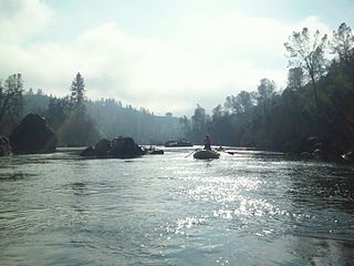
The North Yuba River (also called the North Fork Yuba River) is the main tributary of the Yuba River in northern California in the United States. The river is about 61 miles (98 km) long [4] and drains from the Sierra Nevada westwards towards the foothills between the mountains and the Sacramento Valley.

Yuba River river in the United States of America

The Yuba River is a tributary of the Feather River in the Sierra Nevada and eastern Sacramento Valley, in the U.S. state of California. The main stem of the river is about 40 miles (64 km) long, and its headwaters are split into three major forks. The Yuba River proper is formed at the confluence of the North Yuba and Middle Yuba Rivers, with the South Yuba joining a short distance downstream. Measured to the head of the North Yuba River, the Yuba River is just over 100 miles (160 km) long.

Northern California Place in California, United States

Northern California is the northern portion of the U.S. state of California. Spanning the state's northernmost 48 counties its main population centers include the San Francisco Bay Area, the Greater Sacramento area, and the Metropolitan Fresno area. Northern California also contains redwood forests, along with the Sierra Nevada, including Yosemite Valley and part of Lake Tahoe, Mount Shasta, and most of the Central Valley, one of the world's most productive agricultural regions.

California State of the United States of America

California is a state in the Pacific Region of the United States. With 39.6 million residents, California is the most populous U.S. state and the third-largest by area. The state capital is Sacramento. The Greater Los Angeles Area and the San Francisco Bay Area are the nation's second- and fifth-most populous urban regions, with 18.7 million and 9.7 million residents respectively. Los Angeles is California's most populous city, and the country's second-most populous, after New York City. California also has the nation's most populous county, Los Angeles County, and its largest county by area, San Bernardino County. The City and County of San Francisco is both the country's second-most densely populated major city after New York City and the fifth-most densely populated county, behind only four of the five New York City boroughs.

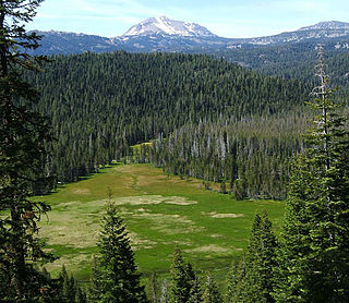
It rises on the Sierra Crest about 8 miles (13 km) northwest of Sierraville. The river flows west through meadows, then south into a gorge, turning west again, followed by California State Route 49. The river's four major tributaries, the Downie River, Goodyears Creek, Canyon Creek and Slate Creek, enter from the right before the river abruptly turns south at the New Bullards Bar Reservoir, formed by the New Bullards Bar Dam. The dam is situated right above the river's mouth; just after the North Yuba leaves the dam it empties into the Middle Yuba River and forms the Yuba River.

Sierra Crest

The Sierra Crest is a ~500 mi (800 km) generally north-to-south ridgeline that demarcates the broad west and narrow east slopes of the Sierra Nevada (U.S.) and that extends as far east as the Sierra's topographic front. The northern and central Sierra Crest sections coincide with over 300 mi (480 km) of the Great Basin Divide, and the southern crest demarcates Tulare and Inyo counties and extends through Kern County to meet the Tehachapi crest. The Sierra Crest also forms two paths (bifurcates) around endorheic cirques between the west and east Sierra slopes.

Sierraville, California census-designated place in California, United States

Sierraville is a census-designated place in Sierra County, California, United States. It is at the southern end of the huge Sierra Valley which is used primarily as pasture and is also at the junction of California State Route 49 and California State Route 89 southwest of Loyalton. Sierraville has a post office with ZIP code 96126. The post office opened under the name Sierra Valley in 1862 and became known as the Sierraville post office in 1899. The population was 200 as of the 2010 census.

California State Route 49 highway in California

State Route 49 is a north–south state highway in the U.S. state of California that passes through many historic mining communities of the 1849 California gold rush. Highway 49 is numbered after the "49ers", the waves of immigrants who swept into the area looking for gold, and a portion of it is known as the Gold Country Highway. This roadway begins at Oakhurst, Madera County, in the Sierra Nevada, where it diverges from State Route 41. It continues in a generally northwest direction, weaving through the communities of Goldside and Ahwahnee, before crossing into Mariposa County. State Route 49 then continues northward through the counties of Tuolumne, Calaveras, Amador, El Dorado, Placer, Nevada, Yuba, Sierra, and Plumas, where it reaches its northern terminus at State Route 70, in Vinton.

Related Research Articles

Feather River river in the United States of America

The Feather River is the principal tributary of the Sacramento River, in the Sacramento Valley of Northern California. The river's main stem is about 73 miles (117 km) long. Its length to its most distant headwater tributary is just over 210 miles (340 km). The main stem Feather River begins in Lake Oroville, where its four long tributary forks join together—the South Fork, Middle Fork, North Fork, and West Branch Feather Rivers. These and other tributaries drain part of the northern Sierra Nevada, and the extreme southern Cascades, as well as a small portion of the Sacramento Valley. The total drainage basin is about 6,200 square miles (16,000 km2), with approximately 3,604 square miles (9,330 km2) above Lake Oroville.

Clavey River river in the United States of America

The Clavey River is a tributary of the Tuolumne River in the Sierra Nevada, located in the Stanislaus National Forest and Tuolumne County, California. The river is 31.3 miles (50.4 km) long, and is one of the few undammed rivers on the western slope of the Sierra. Via the Tuolumne River, the Clavey is part of the San Joaquin River watershed.

Cosumnes River river in the United States of America

The Cosumnes River is a river in northern California in the United States. It rises on the western slope of the Sierra Nevada and flows approximately 52.5 miles (84.5 km) into the Central Valley, emptying into the Mokelumne River in the Sacramento-San Joaquin Delta.

New Bullards Bar Dam

New Bullards Bar Dam is a variable radius concrete arch dam constructed in the early 1960s in California on the North Yuba River. Located near the town of Dobbins in Yuba County, the dam forms the New Bullards Bar Reservoir, which can hold about 969,600 acre⋅ft (1,196,000 dam3) of water. The dam serves for irrigation, drinking water and hydroelectric power generation.

Salmon River (California) tributary to the Klamath River in western Siskiyou County, California

The Salmon River is a 19.6-mile-long (31.5 km) tributary to the Klamath River in western Siskiyou County, California.

New Bullards Bar Reservoir

New Bullards Bar Reservoir is a large reservoir in northeastern Yuba County, California, United States, at an elevation of 2,000 feet (610 m) in the Tahoe National Forest and about 30 miles (50 km) northeast of Yuba City. The 969,600 acre foot (1.1960×10⁹ m3) reservoir is formed by New Bullards Bar Dam on the North Yuba River, a tributary of the Yuba River. It also receives a portion of the Middle Fork's flow that is diverted to the reservoir via tunnels.

Cherry Creek (Tuolumne River tributary)

Cherry Creek is a large, swift-flowing stream in the Sierra Nevada mountain range, and is the largest tributary of the Tuolumne River. The creek is 40 miles (64 km) long measured to its farthest headwaters; the main stem itself is 26 miles (42 km) long, draining a watershed of 234 square miles (610 km2) in the Stanislaus National Forest. Part of the drainage also extends into the northwest corner of Yosemite National Park.

Bear River (Feather River tributary) River in California, United States

The Bear River is a tributary of the Feather River in the Sierra Nevada, winding through four California counties: Yuba, Sutter, Placer, and Nevada. About 73 miles (117 km) long, the river flows generally southwest through the Sierra then west through the Central Valley, draining a narrow, rugged watershed of 295 square miles (760 km2).

South Fork American River river in the United States of America

The South Fork American River is a major tributary of the American River in El Dorado County, California, draining a watershed on the western slope of the Sierra Nevada east of Sacramento. The river begins in pristine Desolation Wilderness and flows through the Sierra Nevada foothills. The river at Coloma was the site of James Marshall's discovery of gold at Sutter's Mill on January 24, 1848, which started the California Gold Rush. The South Fork of the American is "the most popular recreation stream in the West" for whitewater rafting in North America, e.g., 80,000 visitors in 2011.

Middle Fork Feather River river in the United States of America

The Middle Fork Feather River is a major river in Plumas and Butte Counties in the U.S. state of California. Nearly 100 miles (160 km) long, it drains about 1,062 square miles (2,750 km2) of the rugged northern Sierra Nevada range.

South Fork Kern River river in the United States of America

The South Fork Kern River is a tributary of the Kern River in the Sierra Nevada of the U.S. state of California. It is one of the southernmost rivers on the western slope of the mountains, and drains a high, relatively dry plateau country of 982 square miles (2,540 km2) along the Sierra Crest. The upper South Fork flows through a series of rugged canyons, but it also drains a flat, marshy valley before joining the Kern River at Lake Isabella.

Coyote Creek (San Gabriel River tributary) stream in Southern California, tributary of the San Gabriel River

Coyote Creek is a principal tributary of the San Gabriel River in northwest Orange County, southeast Los Angeles County, and southwest Riverside County, California. It drains a land area of roughly 41.3 square miles (107 km2) covering five major cities, including Brea, Buena Park, Fullerton, La Habra, and La Palma. Some major tributaries of the creek in the highly urbanized watershed include Brea Creek, Fullerton Creek, and Carbon Creek. The mostly flat creek basin is separated by a series of low mountains, and is bounded by several small mountain ranges, including the Chino Hills, Puente Hills and West Coyote Hills.

South Yuba River river in the United States of America

The 65.0-mile-long (104.6 km) South Yuba River is a left-entering tributary of the Yuba River originating in the northern Sierra Nevada at Lake Angela in Nevada County about three quarters of a mile north of Donner Pass, about three miles east of the town of Soda Springs. After passing through Lake Van Norden with Upper Castle Creek entering from the right, it gathers numerous snow-fed tributaries running west through a marshy, lake-filled valley, criss-crossing Interstate 80. The river briefly enters Placer County, then flows into Lake Spaulding, then plunges westward into a steep-sided valley. Canyon Creek enters from the right, then Poorman Creek also from the right near the town of Washington. The river continues west into the foothills, crossing under State Route 49. Its mouth is on the east shore of upper Englebright Lake, formed by a dam across the Yuba River.

Middle Yuba River river in the United States of America

The Middle Yuba River is one of the three main forks of the Yuba River in Northern California in the United States. The river rises at the crest of the Sierra Nevada, and flows generally west through canyons to join the North Yuba River near North San Juan. The confluence of the two rivers forms the main stem of the Yuba River, which then continues west to join the Feather River. The Middle Yuba forms much of the border between Nevada County and Sierra County and in its lower reaches a small segment of the Nevada–Yuba County line. The Middle Yuba drains a remote, rugged portion of the Tahoe National Forest, with elevations ranging from 8,373 ft (2,552 m) at English Mountain to 1,129 ft (344 m) at the confluence with the Yuba River.

North Fork American River river in the United States of America

The North Fork American River is the longest branch of the American River in Northern California. It is 88 miles (142 km) long from its source at the crest of the Sierra Nevada, near Lake Tahoe, to its mouth at Folsom Lake northeast of Sacramento. Prior to the construction of Folsom Dam the river was about 9 miles (14 km) longer making for a total length of 97 miles (156 km).

Feather Headwaters

The Feather Headwaters are 3 watersheds totaling 3,450 sq mi (8,900 km2) and which drain to Lake Oroville. The North Fork Feather Watershed is 1,090 sq mi (2,800 km2)—including the West Branch drainage of about 282.5 sq mi (732 km2). The East Branch North Fork Feather Watershed is 1,010 sq mi (2,600 km2), and the Middle Fork Feather Watershed is 1,350 sq mi (3,500 km2)—including the South Fork drainage of about 132 sq mi (340 km2). Headwaters drainage is impaired by the Palermo Canal at Oroville Dam, the Hendricks Canal at the West Branch Feather River, and the Miners Ranch Canal at the South Fork's Ponderosa Reservoir. Additionally, the Pacific Gas and Electric Company releases Upper Feather water into the Hyatt Generating-Pumping Plant for hydroelectric generation during daily peak demand.

North Fork Kings River river in the United States of America

The North Fork Kings River is a 40.3-mile (64.9 km) tributary of the Kings River, in the U.S. state of California. The river's main stem is entirely within Fresno County, and its watershed drains about 387 square miles (1,000 km2) of the southern Sierra Nevada mountain range.

Middle Fork American River river in the United States of America

The Middle Fork American River is one of three forks that form the American River in Northern California. It drains a large watershed in the high Sierra Nevada west of Lake Tahoe and northeast of Sacramento in Placer and El Dorado Counties, between the watersheds of the North Fork American River and South Fork American River. The Middle Fork joins with the North Fork near Auburn and they continue downstream to Folsom Lake as the North Fork, even though the Middle Fork carries a larger volume of water.

Middle Fork Stanislaus River river in the United States of America

The Middle Fork Stanislaus River is a 45.7-mile (73.5 km) tributary of the Stanislaus River in the central Sierra Nevada and Stanislaus National Forest of eastern California.

References

  1. USGS monthly discharge data, accessed 2015-01-23
  2. USGS monthly discharge data, accessed 2015-01-23
  3. USGS annual peak-discharge data, accessed 2015-01-23
  4. U.S. Geological Survey. National Hydrography Dataset high-resolution flowline data. The National Map, accessed March 10, 2011