
Lower Austria is one of the nine states of Austria, located in the northeastern corner of the country. Major cities are Amstetten, Krems an der Donau, Wiener Neustadt and Sankt Pölten, which has been the capital of Lower Austria since 1986, replacing Vienna, which became a separate state in 1921. With a land area of 19,186 km2 (7,408 sq mi) and a population of 1.699 million people, Lower Austria is the largest and second-most-populous state in Austria.
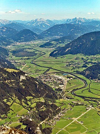
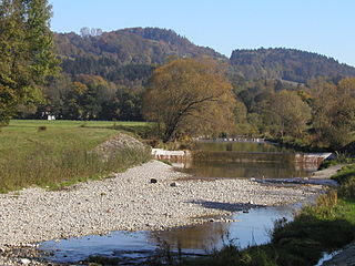
The Enns is a southern tributary of the river Danube in Austria, joining northward at the city of Enns. It forms much of the border between the states of Lower Austria and Upper Austria. The Enns spans 253 kilometres (157 mi), in a flat-J-shape. It flows from its source near the village Flachau, generally eastward through Radstadt, Schladming, and Liezen, then turns north near Hieflau, to flow past Weyer and Ternberg through Steyr, and further north to the Danube at Enns.

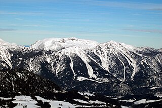
The Central Eastern Alps, also referred to as Austrian Central Alps or just Central Alps, comprise the main chain of the Eastern Alps in Austria and the adjacent regions of Switzerland, Liechtenstein, Italy and Slovenia. South of them is the Southern Limestone Alps.

Bischofshofen is a town in the district of St. Johann im Pongau in the Austrian federal state of Salzburg. It is an important traffic junction located both on the Salzburg-Tyrol Railway line and at the Tauern Autobahn, a major highway route crossing the main chain of the Alps.

The Radstadt Tauern are a subrange of the Central Eastern Alps in Austria. Together with the Schladming Tauern, the Rottenmann and Wölz Tauern and the Seckau Tauern the Radstadt Tauern form the major range of mountains known as the Low Tauern. The mountains are found in the southeast of the Austrian state of Salzburg, between the upper reaches of the Enns and Mur rivers.

Ybbs is a river in Lower Austria. Its drainage basin is 1,291 km2 (498 sq mi).
The Gölsen is a river in Lower Austria, in the Mostviertel. It is a right tributary of the Traisen. Its drainage basin is 297 km2 (115 sq mi).
The Ennstal Alps, the Alps of the Enns valley, are a mountain range of the Northern Limestone Alps System. They are located primarily in the Austrian state of Styria, and also into the state of Upper Austria.

Ramsau am Dachstein is a municipality in the district of Liezen, state of Styria, Austria. It is also the name of the elevated plateau between the Dachstein range and the Enns valley on which this municipality is located.

Montan an der Weinstraße is a municipality with 1,701 inhabitants and a village in the South of South Tyrol in northern Italy, about 15 km south of Bolzano. The name Montan derives from the Latin mons ("mountain").

Aigen im Ennstal is a municipality in the district of Liezen in Styria, Austria. It was one of the locations used for filming "Where Eagles Dare".
The Upper Austrian Prealps is a mountain range in Austria which, according to the Categorisation of the Eastern Alps, covers the region between the valley of the Traun (Gmunden) in the west and the Enns valley in the east, from Steyr in the north. It is usually counted as part of the Enns- and Steyrtal Prealps and Salzkammergut Prealps. Politically it covers the districts of Steyr-Land and Kirchdorf. Large parts are located within the Limestone Alps National Park.
The Western Railway is a two-track, partly four-track, electrified railway line in Austria that runs from Vienna to Salzburg via St. Pölten and Linz Hauptbahnhof and is one of the major lines of Austria. It was originally opened as the Empress Elisabeth Railway in 1858 (Vienna–Linz). The line is owned and operated by Austrian Federal Railways (ÖBB).

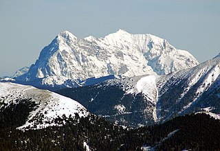
The Dachstein Mountains are a mountain range in the Northern Limestone Alps.
The Salzburg-Tyrol Railway is a main line railway in Austria. It runs through the states of Salzburg and Tyrol from the city of Salzburg to Wörgl and belongs to the core network (Kernnetz) of the Austrian Federal Railways (ÖBB). The section between Salzburg and Schwarzach-Sankt Veit is part of the Salzburg S-Bahn urban railway network.

A longitudinal valley is an elongated valley found between two almost-parallel mountain chains in geologically young fold mountains, such as the Alps, Carpathians, Andes, or the highlands of Central Asia. They are often occupied and shaped by a subsequent stream. The term is frequently used if a mountain range also has prominent transverse valleys, where rivers cut through the mountain chains in so-called water gaps.
Stainach-Pürgg is a municipality since 2015 in the Liezen District of Styria, Austria.

The Rudolf Railway refers to a railway in Austria connecting Amstetten and the Italian border near Tarvisio, along with a branch from Kastenreith to St. Valentine. Its name is derived from the k.k. priv. Kronprinz Rudolf-Bahn Gesellschaft. The main line, which was opened from 1868 to 1873, ran on the St. Valentin–Kastenreith–Kleinreifling–Selzthal–Schoberpass–St. Michael–Neumarkt saddle–St. Veit an der Glan–Feldkirchen in Kärnten–Villach–Tarvisio Centrale route. The section of the line within the current borders of Italy now runs over the new Tarvisio–Udine railway through Tarvisio Boscoverde. It replaced a very windy route to Udine that originally formed part of the Rudolf Railway.

The Salzkammergut railway line is a standard gauge railway line in the Austrian states of Styria and Upper Austria. It runs 171.1 kilometres (106.3 mi) from a junction with the Wels–Passau railway line near Schärding to a junction with the Enns Valley Railway in Stainach. Austrian Federal Railways (ÖBB) owns and operates the line. The name refers to the Salzkammergut region through which the line runs.
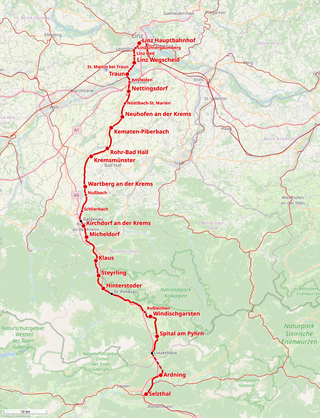
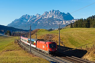
The Pyhrn railway line is a railway line in Upper Austria. It runs 104.2 kilometres (64.7 mi) from Linz Hauptbahnhof, where it connects with the Western railway line, to Selzthal, where it connects with the Enns Valley Railway and Rudolf Railway. The line takes its name from the Pyhrn Pass through which it runs.
