Greene County is a county located in the west central portion of the U.S. state of Alabama. As of the 2020 census, the population was 7,730, the least populous county in Alabama. Its county seat is Eutaw. It was named in honor of Revolutionary War General Nathanael Greene of Rhode Island.
Hale County is a county located in the west central portion of the U.S. state of Alabama. As of the 2020 census, the population was 14,785. Its county seat is Greensboro. It is named in honor of Confederate officer Stephen Fowler Hale.
Eutaw is a city in and the county seat of Greene County, Alabama, United States. At the 2020 census, the population was 2,937. The city was named in honor of the Battle of Eutaw Springs, the last engagement of the American Revolutionary War in the Carolinas.

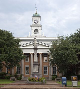
Greensboro is a city in Hale County, Alabama, United States. At the 2010 census the population was 2,497, down from 2,731 at the 2000 census. The city is the county seat of Hale County, Alabama, which was not organized until 1867. It is part of the Tuscaloosa, Alabama Metropolitan Statistical Area.

Newbern is a town in Hale County, Alabama, United States. As of the 2020 census, the population of the town was 133.

Greensboro is a city in and the county seat of Greene County, Georgia, United States. Its population was 3,648 as of the 2020 census. The city is located approximately halfway between Atlanta and Augusta on Interstate 20.

The Black Belt is a region of the U.S. state of Alabama. The term originally referred to the region's rich, black soil, much of it in the soil order Vertisols. The term took on an additional meaning in the 19th century, when the region was developed for cotton plantation agriculture, in which the workers were enslaved African Americans. After the American Civil War, many freedmen stayed in the area as sharecroppers and tenant farmers, continuing to comprise a majority of the population in many of these counties.
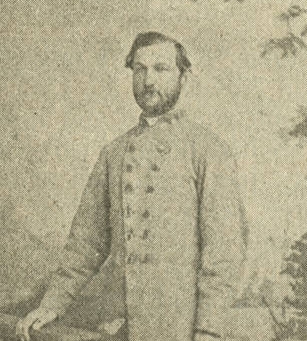
Thomas Hord Herndon was a U.S. Representative from Alabama who also served as an officer in the Confederate States Army during the American Civil War.

The William Perkins House, now known as the Freemount, is a historic Greek Revival style house in Eutaw, Alabama, United States. The house is a two-story wood-framed building on a raised brick foundation. Four monumental Ionic columns span the front portico. It was built in 1850 by William Perkins on the Eutaw Town Square. According to the 1850 U. S. Federal Census Slave Schedule, William Perkins' household in Greene County included eleven enslaved people, four women and seven men. Their ages ranged from 2–45 years old, and Mr. Perkins is listed as the slave owner. The house was recorded by the Historic American Buildings Survey in 1934. It was added to the National Register of Historic Places as a part of the Antebellum Homes in Eutaw Thematic Resource on April 2, 1982, due to its architectural significance. It is also listed on the Alabama Register of Landmarks and Heritage.

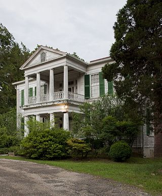
The Asa White House, also known as the White-McGiffert House, is a historic house in Eutaw, Alabama, United States. It was built in 1838 by Asa White, one of Greene County's earliest settlers. Eutaw was established on property owned by Asa White. He conveyed 20 acres (8.1 ha) to the newly established county seat in 1838 for the building of a courthouse, civic buildings, and a commercial district. He then sold residential lots to individuals. His house is a two-story frame building. It was built in the Federal style and later altered with the addition of Greek Revival-influenced details. The house was recorded by the Historic American Buildings Survey in 1936. It was added to the National Register of Historic Places as a part of the Antebellum Homes in Eutaw Thematic Resource on April 2, 1982, due to its architectural significance.
Glencairn, also known as the John Erwin House, is a historic house in Greensboro, Alabama, United States. The house and grounds were recorded by the Historic American Buildings Survey in 1935. The house was added to the National Register of Historic Places on January 18, 1978, due to its architectural and historical significance.

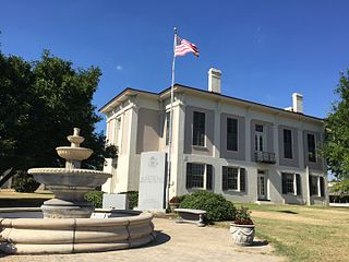
The Old Greene County Courthouse is a historic courthouse in Eutaw, Alabama, United States. It housed the seat of government for Greene County from 1869 until 1993. The building is a two-story masonry structure in the Greek Revival style with Italianate influences. Architect Clay Lancaster proposed that it may be the last Greek Revival public building to be built in Alabama. It replaced an earlier wooden courthouse on the same site that was built in 1838. The prior courthouse was burned in 1868, in what is considered by most historians to have been a deliberate act of arson that was executed to destroy indictments brought by the recently installed Radical Reconstruction government against local citizens. The fire destroyed paperwork pertaining to some 1,800 suits by freedmen against planters which were about to be acted on. The courthouse was placed on the National Register of Historic Places on March 24, 1971, due to its architectural significance.

Prairie Bluff, also known as Dale and Daletown, is a ghost town in Wilcox County, Alabama.
Sawyerville, previously known as Sawyers Depot, is an unincorporated community in west-central Hale County, Alabama and is a part of the Tuscaloosa metropolitan area. It derives its name from the town's first post master. The community is rural and came to flourish due to its proximity to the railroad that once traveled through it. The community covers the historic area of the county once called Hollow Square and includes the abandoned town site of Erie, the former county seat of Greene County. It also includes the communities of Wedgeworth, Melton, Warrior Dam, and Mason Bend. The area was the site of several Pickens family plantations, most notably those of early Alabama governor, Israel Pickens, and his younger brother, Samuel Pickens. The Samuel Pickens homestead, Umbria Plantation, was destroyed by fire in 1971.

Clinton is an unincorporated community in Greene County, Alabama, United States. Clinton is located at the junction of Alabama routes 14 and 39, 7.9 miles (12.7 km) northwest of Eutaw. Clinton has a post office with ZIP code 35448.
Eutaw is a ghost town in Bolivar County, Mississippi, United States. The settlement had a port on the Mississippi River called "Eutaw Landing."

Dudleyville, also known as Pittsborough, is an unincorporated community in Tallapoosa County, Alabama, United States. Dudleyville was named for Peter Dudley, who established the first trading post in the area. The town was incorporated on February 2, 1839. A post office was operated in Dudleyville from 1836 to 1907. Major Lemuel Montgomery, the first American soldier killed in the Battle of Horseshoe Bend, was formerly buried in the Dudleyville cemetery, before his grave was moved to Horseshoe Bend National Military Park. Abram Mordecai, a trader who installed the first cotton gin in Alabama, lived for a time in Dudleyville. It was here that Albert J. Pickett visited him in 1847 and gathered information from him to use in his History of Alabama. County Line Baptist Church, which is located east of Dudleyville, is listed on the National Register of Historic Places.
Liverpool is a ghost town in Yazoo County, Mississippi, United States. Liverpool Landing, the settlement's port on the Yazoo River, was located 0.9 mi (1.4 km) west of Liverpool.
Mount Hebron, also known as Hebron, is an unincorporated community in Greene County, Alabama, United States. Mount Hebron is located on Alabama State Route 39, 11.4 miles (18.3 km) west-northwest of Eutaw.

Chinnabee, also spelled Chinneby or Chinnibee, is an unincorporated community in Talladega County, Alabama, United States.


