Eriyur

Last updated

Eriyur
Village
Eriyur Malai Marundheeswarar Temple.jpg
Sri Malai Marundheeswarar Temple
India Tamil Nadu location map.svg
Red pog.svg
Eriyur
Location in Tamil Nadu, India
India location map 3.png
Red pog.svg
Eriyur
Eriyur (India)
Coordinates: 10°02′20″N78°30′45″E / 10.0389646°N 78.5125496°E / 10.0389646; 78.5125496 Coordinates: 10°02′20″N78°30′45″E / 10.0389646°N 78.5125496°E / 10.0389646; 78.5125496
CountryFlag of India.svg  India
State Tamil Nadu
District Sivaganga
Taluk Singampunari block
Government
  TypeGrama Panchayat
Population
 (2011)
  Total2,353 [1]
Languages
  Official Tamil, English
Time zone UTC+5:30 (IST)
Postal Code
630566 [2]
Telephone code04577 [3]
Lok Sabha constituency Sivaganga (Lok Sabha constituency) [4]
State Assembly Constituency Tiruppattur (state assembly constituency, Sivaganga)

Eriyur is a village in Singampunari Taluk [5] [6] in Sivaganga district of Tamil Nadu, India. It is a large village consisting of two Panchayat villages: Eriyur and Mampatti Devasthanam. The adjoining villages Valayapatti and Ulaginipatti are also administratively and culturally linked to Eriyur. [7] [8] [9] [10] [11] [12] It is a constituent of the ancient "MayilrayanKottai Nadu" once, which was a part of 'Sivagangai Seemai'.

Contents

Location

It is located 26 km North from District headquarters Sivagangai. Other nearby towns are Melur and Tirupathur. It is about 8 km away from Thirukoshtiyur which has one of the 108 Divya desam temples dedicated to Lord Vishnu. S.Mampatti ( 4 km ), Namanur ( 9.2 km ), Alavakottai ( 7.1 km ), Kattanipatti ( 9.3 km ), Mallakottai ( 7 km ),Jeyankondanilai(8 km), Madagupatti ( 7.7 km ) are the nearby Villages to Eriyur. It is well connected to Tirupathur, Melur and Madurai by private and Tamil Nadu State Transport bus lines. [13]

History

Eriyur is a modern village with long history and deep links to heritage. It is a constituent of the ancient "MayilrayanKottai Nadu". Main occupation of the people is agriculture and trading.

Culture

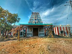
Main attraction of the village is the Malai Marundheeeswarar Temple (Tamil : மலை மருந்தீஸ்வரர் ஆலயம்). It is located at the top of the hill on the eastern side of the village. This temple is dedicated to Lord Shiva. "Pankuni Uthiram" festival celebrated in the month of March/ April is the major annual festival in this village. It is a 10-day festival for Lord Muruga situated in the Malai Marundheeswarar temple. This festival attracts devotees from around the villages. Most of the natives living outside of the village returns home to participate in the festival. Another major festival is the Pongal festival in the month of January.

Related Research Articles

Alangulam is a village in Vembakkottai block, Vembakottai taluk, Virudhunagar district in the state of Tamil Nadu in India. The state-government-run cement and asbestos factory is located here. The area is rich in limestone and asbestos. A nearby school addresses the needs of local students. This area contains Three primary government schools and One Higher secondary school. The private schools are Tancem Educational Trust Matric Hr sec School run by Tamil Nadu Cements and Maheswari Nursery Primary school.

Thiruvengadam is a panchayat town Revenue Village in Thiruvengadam Taluk, Panchayat village in Kuruvikulam Block in Tenkasi district in the Indian state of Tamil Nadu.

Nattuchalai is a village in the Pattukkottai taluk of Thanjavur district, Tamil Nadu, India. Jeyaratha Arunagiri is a councilor. Jayanthi is a president. Nattuchalai is also called as NTC by the surrounding people.

Mathur is a village in the Kumbakonam taluk, Thiruvidaimarudur block of Thanjavur district, Tamil Nadu, India.

Kuvagam is a village in the Udayarpalayam taluk of Ariyalur district, Tamil Nadu, India.

Othavanthankudi is a village in Sirkazhi taluk, Mayiladuthurai district, Tamil Nadu, India. The village is located in the Sirkazhi legislative assembly constituency. The village includes a St. Anthony's church. Othavanthankudi is connected to Sirkazhi, Chidambaram and Pazhaiyar by bus.

Kuruvikulam is a panchayat in southern Tamil Nadu. This panchayat is located in Kuruvikulam Block, Thiruvenkatam taluk, Tenkasi district. The nearest railway station for kuruvikulam is sankarankovil town(15 km).

Rayakottai, also spelled Rayakotta is a town in Denkanikottai taluk, Krishnagiri District, Tamil Nadu, India. It is 73 kilometres (45 mi) from Bangalore.

Panampatti devandira Kula velalar is a village in the Annavasalrevenue block of Pudukkottai district, Tamil Nadu,Demographics. Panampatti is a villagefalls under the ambit of Illupur taluk, Pudukottai, the village has very famous for Pumalandi, the temple was managed by five village and once in every five year the festival will celebrated in the name of Padyal, huge numbers of pilgrims throng to temple to pray the god.

Thayamangalam is a small town in the Sivaganga district in the Indian state of Tamil Nadu. The town is 68 km from Madurai and comes under the Ilaiyankudi block. This town has a temple popularly known as Arulmigu Muthumariamman Thirukovil. The town takes its name from the goddess 'Thai' means mother.

Guziliamparai is announced as new taluk on 31.12.17 by honourable chief minister k.Edapadi palanisamy.

Reddiyarchatiram block is a revenue block of Dindigul district of the Indian state of Tamil Nadu. This revenue block consist of 24 panchayat villages.

Mallakottai Village in Tamil Nadu, India

Mallakottai is the name of a panchayat village in the Indian state of Tamil Nadu. It was one of the villages of the ancient "Mallakottai Nadu" once, which was a part of 'Sivagangai Seemai'..

Kalingapatty is a panchayat Village in Tenkasi district in the Indian state of Tamil Nadu. This village is under the control of Kuruvikulam block, Sankarankoil taluk

Dharugapuram is a panchayat Village in Tenkasi district in the Indian state of Tamil Nadu. This village is under the control of Vasudevanallur block Sivagiri taluk

Keelappoongudi is a panchayat Village in Sivaganga district in the Indian state of Tamil Nadu. This village is under the control of Sivaganga block. Sivaganga taluk

Alampattu Village in Tamil Nadu, India

Alampattu is a village in the state of Tamil Nadu, Sivaganga District, India. It is 20 km from the town Karaikudi.

Theppakadu Place in Tamil Nadu, India

Theppakadu is a village in the Nilgiris district in the Indian state of Tamil Nadu. It has a reserve forest which is part of the Mudumalai National Park in western Tamil Nadu touching the south of Karnataka. Theppakadu is 240 km (150 mi) from Bangalore, via Mysore through SH17 and NH 212.

Kothavadi is a village in Kinathukadavu Taluk, Coimbatore district in the Indian state of Tamil Nadu. Kothavadi is the birthplace of Indian space scientist Mylswamy Annadurai.

Mampatti Village in Tamil Nadu, India

Mampatti is a village in Singampunari Taluk in Sivagangai District of Tamil Nadu State, India. It comes under Mampatti South panchayath union. It is a constituent of the ancient "MayilrayanKottai Nadu" once, which was a part of 'Sivagangai Seemai'. For administrative purpose, the whole Mampatti region was divided into three Revenue Villages namely South Mampatti, North Mampatti and Mampatti Devasthanam, each under the authority of a Village Administrative Officer. Mampatti Devasthanam is the region that covers the land of temples that belongs to Sivagangai Samasthanam Devasthanam.

References

  1. "Eriyur Village Population - Tirupathur - Sivaganga, Tamil Nadu".
  2. https://web.archive.org/web/20150311143736/http://www.indiapost.gov.in/pinsearch.aspx. Archived from the original on 11 March 2015. Retrieved 11 March 2015.{{cite web}}: Missing or empty |title= (help)
  3. "Indian STD Code list / ISD Codes - Indian Yellow Pages - Indiacom Limited".
  4. (PDF) https://web.archive.org/web/20150402090026/http://elections.tn.gov.in/pslist/english/sivaganga_eng.pdf. Archived from the original (PDF) on 2 April 2015. Retrieved 24 March 2015.{{cite web}}: Missing or empty |title= (help)
  5. "CM orders creation of five new taluks". The New Indian Express. 17 September 2016. Retrieved 8 October 2018.
  6. http://www.sivaganga.tn.nic.in/Admnsetu.html [ dead link ]
  7. http://tnmaps.tn.nic.in/vill.php?dcode=23&centcode=0001&tlkname=Tirupathur#MAP [ dead link ]
  8. http://tnmaps.tn.nic.in/pr_villages.php?dc=23&tlkname=Tirupathur&region=0001&lvl=taluk&size=1200 [ dead link ]
  9. http://tnmaps.tn.nic.in/blks_info.php?dcode=23&blk_name=&dcodenew=25&drdblknew=7 [ dead link ]
  10. http://tnmaps.tn.nic.in/pr_villages.php?dc=23&tlkname=Singampunari&region=7&lvl=block&size=1200 [ dead link ]
  11. Sivaganga district
  12. http://www.tnrd.gov.in/databases/Villages.pdf [ bare URL PDF ]
  13. Thirukoshtiyur