Escondido River (Coahuila)

Last updated
Escondido River
CountryMexico
StateCoahuila
Physical characteristics
SourceSerranias del Burro
 - coordinates 28°41′58″N101°31′2″W / 28.69944°N 101.51722°W / 28.69944; -101.51722 [1]
 - elevation1,000 m (3,300 ft) [1]
River mouth Rio Grande
 - locationPiedras Negras
 - coordinates 28°39′43″N100°30′2″W / 28.66194°N 100.50056°W / 28.66194; -100.50056 Coordinates: 28°39′43″N100°30′2″W / 28.66194°N 100.50056°W / 28.66194; -100.50056 [2]
 - elevation200 m (660 ft) [1]
Length150 km (93 mi) [1]
Discharge 
 - location IBWC station 08-4581.50 at Villa de Fuente, Coahuila [3]
 - minimum0 m3/s (0 cu ft/s)
 - average1.64 m3/s (58 cu ft/s) [3]
 - maximum883 m3/s (31,200 cu ft/s)
Basin features
Basin size3,810 km2 (1,470 sq mi) [3]

The Escondido River (Río Escondido in Spanish, sometimes called Arroyo Río Escondido [4] ) is a stream in the state of Coahuila, Mexico, and is a tributary of the Rio Grande.

Coahuila State of Mexico

Coahuila, formally Coahuila de Zaragoza, officially the Free and Sovereign State of Coahuila de Zaragoza, is one of the 31 states which, along with Mexico City, compose the 32 Federal Entities of Mexico.

Mexico country in the southern portion of North America

Mexico, officially the United Mexican States, is a country in the southern portion of North America. It is bordered to the north by the United States; to the south and west by the Pacific Ocean; to the southeast by Guatemala, Belize, and the Caribbean Sea; and to the east by the Gulf of Mexico. Covering almost 2,000,000 square kilometres (770,000 sq mi), the nation is the fifth largest country in the Americas by total area and the 13th largest independent state in the world. With an estimated population of over 120 million people, the country is the eleventh most populous state and the most populous Spanish-speaking state in the world, while being the second most populous nation in Latin America after Brazil. Mexico is a federation comprising 31 states and Mexico City, a special federal entity that is also the capital city and its most populous city. Other metropolises in the state include Guadalajara, Monterrey, Puebla, Toluca, Tijuana and León.

Rio Grande river forming part of the US-Mexico border

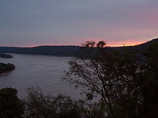
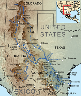
The Rio Grande is one of the principal rivers in the southwest United States and northern Mexico. The Rio Grande begins in south-central Colorado in the United States and flows to the Gulf of Mexico. Along the way, it forms part of the Mexico–United States border. According to the International Boundary and Water Commission, its total length was 1,896 miles (3,051 km) in the late 1980s, though course shifts occasionally result in length changes. Depending on how it is measured, the Rio Grande is either the fourth- or fifth-longest river system in North America.

The Escondido enters the Rio Grande (Rio Bravo del Norte in Mexico) at Rio Grande river kilometer 794 kilometres (493 mi), about 5 kilometres (3.1 mi) downriver from Piedras Negras, Coahuila, and Eagle Pass, Texas. [3]

River mile

In the United States, a river mile is a measure of distance in miles along a river from its mouth. River mile numbers begin at zero and increase further upstream. The corresponding metric unit using kilometers is the river kilometer. They are analogous to vehicle roadway mile markers, except that river miles are rarely marked on the physical river; instead they are marked on navigation charts, and topographic maps. Riverfront properties are sometimes partially legally described by their river mile.

Piedras Negras, Coahuila Place in Coahuila, Mexico

Piedras Negras is a city and seat of the surrounding municipality of the same name in the Mexican state of Coahuila. It stands at the northeastern edge of Coahuila on the U.S.-Mexico border, across the Rio Grande from Eagle Pass in the U.S. state of Texas. In the 2015 census the city had a population of 163,595 inhabitants, while the metropolitan area had a population of 245,155 inhabitants. The Piedras Negras and the Eagle Pass areas are connected by the Eagle Pass-Piedras Negras International Bridge, Camino Real International Bridge, and the Eagle Pass Union Pacific International Railroad Bridge.

Eagle Pass, Texas City in Texas, United States

Eagle Pass is a city in and the county seat of Maverick County in the U.S. state of Texas. The population was 26,255 as of the 2010 census.

The Escondido originates in the Serranias del Burro mountain range and flows generally east to the Rio Grande. Its main tributary is the Rio San Antonio, which enters the Escondido about 19 kilometres (12 mi) upriver from the Rio Grande confluence. [3]

See also

Related Research Articles

Uruguay River river in South America

The Uruguay River is a river in South America. It flows from north to south and forms parts of the boundaries of Brazil, Argentina, and Uruguay, separating some of the Argentine provinces of La Mesopotamia from the other two countries. It passes between the states of Santa Catarina and Rio Grande do Sul in Brazil; forms the eastern border of the provinces of Misiones, Corrientes, and Entre Ríos in Argentina; and makes up the western borders of the departments of Artigas, Salto, Paysandú, Río Negro, Soriano, and Colonia in Uruguay.

Pelotas River river in Brazil

The Pelotas River is a river in southern Brazil, and a tributary of the Uruguay River.

The Saladillo Stream is a small tributary of the Paraná River, that discharges into it between the cities of Rosario and Villa Gobernador Gálvez, in the province of Santa Fe, Argentina. It serves as the political border between these two towns of the Greater Rosario area, and is one of the two important affluents of the Paraná in the area, together with the Ludueña Stream in the north.

Salado River (Argentina) river in Argentina

The Salado River is a river that crosses several provinces of Argentina, flowing 1,150 kilometres (710 mi) from its source in the Salta Province to end in the Paraná River, in the Santa Fe Province. Because its origin, its flow varies widely within the year, and it can dry out in some parts of its path during the winter. The only important tributary to the river is the Horcones River, which is born in Salta as Cajón River, and joins the Salado in the Santiago del Estero Province.

Rio Conchos river in Mexico

The Río Conchos is a large river in the Mexican state of Chihuahua. It joins the Río Bravo del Norte at the town of Ojinaga, Chihuahua.

Grande de Santiago River river in Mexico

The Grande de Santiago River is one of the longest rivers in Mexico, measuring up 433 km (269 mi) long. The river begins at Lake Chapala and continues roughly north-west through the Sierra Madre Occidental, receiving the Verde, Juchipila, Bolaños, and other tributaries. At La Yesca, the La Yesca Dam was completed in 2012 and the El Cajón Dam was completed downstream in 2007. Below El Cajón, the Aguamilpa Dam was completed in 1993, creating a reservoir covering a large part of the territory of the municipality of El Nayar in Nayarit. From Aguamilpa, the river descends to the coastal lowlands, passing by Santiago Ixcuintla and empties into the Pacific Ocean, 16 km (10 mi) northwest of San Blas, in Nayarit. The river is viewed by some sources as a continuation of the Lerma River, which flows into Lake Chapala.

Rio Chama

The Rio Chama, a major tributary river of the Rio Grande, is located in the U.S. states of Colorado and New Mexico. The river is about 130 miles (210 km) long altogether. From its source to El Vado Dam its length is about 50 miles (80 km), from El Vado Dam to Abiquiu Dam is about 51 miles (82 km), and from Abiquiu Dam to its confluence with the Rio Grande is about 34 miles (55 km).

The Feliciano River is a river in the Argentine province of Entre Ríos, in the Mesopotamia. It is born on the Lomada del Mocoretá, on the northeast of the province, east of San José de Feliciano, and flows west-southwest across the province. Its course receives the waters of several streams, and after 198 kilometres (123 mi) it empties into the Paraná River near Piedras Blancas.

San Juan River (Tamaulipas) river in Mexico

The San Juan River is the largest and most important river in the Mexican state of Nuevo León. The river feeds the El Cuchillo Dam, which provides the city of Monterrey with water. The San Juan River basin has a total surface area of 33,538 square kilometres (12,949 sq mi). The San Juan River is a tributary to the Rio Grande — which is the fourth largest river basin in North America. It begins in Coahuila, flows through Nuevo León and into Tamaulipas, where it finally joins the Rio Grande near Camargo, Tamaulipas.

Rio Puerco (Rio Grande tributary) river in the United States of America

The Rio Puerco is a tributary of the Rio Grande in the U.S. state of New Mexico. From its source on the west side of the Nacimiento Mountains, it flows about 230 miles (370 km), generally south to join the Rio Grande about 20 miles (32 km) south of Belen and about 50 miles (80 km) south of Albuquerque. Its drainage basin is about 7,350 square miles (19,000 km2) large, of which probably about 1,130 square miles (2,900 km2) are noncontributing.

Rio Salado (Mexico) river in northern Mexico

The Río Salado, also Río Salado de los Nadadores, or Salado River, is a river in northern Mexico, a tributary of the Rio Grande (Río Bravo). Its basin extends across the northern portion of Coahuila, Nuevo Leon, and Tamaulipas states.

Arapey Grande River river in Uruguay

The Arapey Grande River is a river in the Salto Department of northwestern Uruguay. It flows from the northeast of department, with its headwaters near the border with Rivera Department, in a western direction and discharges in the Uruguay River. Its length is about 227 kilometres (141 mi). All of its tributaries are streams within Salto department, with its main tributaries streams being Arroyo Sarandí del Arapey, Arroyo Cambara, Arroyo Mataojo Chico, Arroyo Mataojo Grande, Arroyo del Sauce, Arroyo Valentín Grande and the Arapey Chico River, which forms part of the border with Artigas Department and has some tributaries from that department.

The Rio Hondo is a 79-mile-long (127 km) river in southern New Mexico which begins at the confluence of the Rio Bonito and Rio Ruidoso rivers near the town of Hondo, New Mexico. The river flows eastward through the Hondo Valley in the foothills of the Sierra Blanca and Capitan Mountains, roughly paralleling the route of U.S. Route 70 through the towns of Picacho and Tinnie. Near the community of Riverside the river passes through a deep canyon before entering the rolling hills west of Roswell.

The Río Álamo, is a stream in the state of Tamaulipas, Mexico, and is a tributary of the Rio Grande. It is impounded by Las Blancas Dam, which was completed in 2001 and diverts water to the Marte Gómez Reservoir on the Rio San Juan, another tributary of the Rio Grande.

The Río San Rodrigo is a stream in the state of Coahuila, Mexico, and is a tributary of the Rio Grande.

Jemez River river in the United States of America

The Jemez River is a tributary of the Rio Grande in the U.S. state of New Mexico. The river is formed by the confluence of the East Fork Jemez River and San Antonio Creek, which drain a number of tributaries in the area of the Jemez Mountains and Santa Fe National Forest. The Jemez River is about 50 miles (80 km) long, or about 80 miles (130 km) long if its longest headwater tributary, San Antonio Creek, is included. The East Fork Jemez River is about 22 miles (35 km) long. Both San Antonio Creek and the East Fork Jemez River flow through intricate meanders along their courses. The East Fork Jemez is a National Wild and Scenic River.

Rio Pueblo de Taos River in New Mexico, USA

The Rio Pueblo de Taos, also known as Rio Pueblo, is a tributary of the Rio Grande in the U.S. state of New Mexico. From its source in the Sangre de Cristo Mountains it flows about 33 miles (53 km), generally south and west, to join the Rio Grande in the Rio Grande Gorge. On the way the river passes by Taos and through Taos Pueblo.

Rio Salado (New Mexico) river in the United States of America

The Rio Salado is a tributary of the Rio Grande in the U.S. state of New Mexico. From its source in northeast Catron County it flows about 86 miles (138 km) generally east to join the Rio Grande just north of Polvadera and about 15 miles (24 km) north of Socorro. The name Río Salado is Spanish for "salty river".

References

  1. 1 2 3 4 Calculated in Google Maps
  2. Rio Escondido at GEOnet Names Server and adjusted with Google Maps
  3. 1 2 3 4 5 "Water Bulletin Number 75: Flow of the Rio Grande and Related Data; From Elephant Butte Dam, New Mexico to the Gulf of Mexico". International Boundary and Water Commission. 2005. Archived from the original on 26 September 2010. Retrieved 17 July 2010.
  4. Arroyo Río Escondido at GEOnet Names Server