Related Research Articles

The Biobío River is the second largest river in Chile. It originates from Icalma and Galletué lakes in the Andes and flows 380 km to the Gulf of Arauco on the Pacific Ocean.

Laja River is a river in Chile, along which can be found the Laja Falls. It is located in the Bío Bío Region. The source of the river is Laguna del Laja in the Andes, then flows westward through the Chilean Central Valley and terminates into the Bío Bío River, being an important tributary of it.

La Dehesa is a suburban neighborhood in Lo Barnechea Commune of Santiago, Chile. It borders Las Condes to the south and Vitacura to the west. It is located in a valley near the Andes, in the northeast of the city, north of the Mapocho River. La Dehesa is known as one of Chile's most affluent neighborhoods.
The Central Valley, Intermediate Depression, or Longitudinal Valley is the depression between the Chilean Coastal Range and the Andes Mountains. The Chilean Central Valley extends from the border with Peru to Puerto Montt in southern Chile, with a notable interruption at Norte Chico. South of Puerto Montt the valley has a continuation as a series of marine basins up to the isthmus of Ofqui. Some of Chile's most populous cities lie within the valley including Santiago, Temuco, Rancagua, Talca and Chillán.
Beamud is a municipality located in the province of Cuenca, Castile-La Mancha, Spain. It has a population of 48 (2014).
La Frontera is the name given to a geographical region in Chile. La Frontera can denote either the area just around Bío Bío River or the whole area between the Bío Bío and Toltén River being in this later definition largely coterminous with the historical usage of Araucanía.

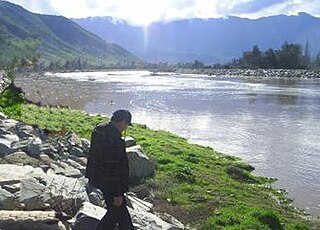
The Andalién River is a river in the province of Concepción, in the Bío Bío Region of Chile. It drains the western side of Chile's Cordillera de la Costa and has a total length of 42 kilometres (26 mi). It is one of the two rivers that bracket the city of Concepción.

The Colorado River is a river of Chile.
The Estero Alhué is a river of Chile.
The Estero Carén is a river of Chile.
The Estero Chacabuco is a river of Chile.
The Estero Coya is a river of Chile.
The Estero Lampa is a river of Chile.
The Estero Los Loros is a river of Chile.
The Estero Pocuro is a river of Chile.

The Estero Yerba Loca is a river of Chile.
The Estero Zamorano is a river of Chile.
San Antonio de Petrel is a small Chilean village located near the hacienda of the same name, in Pichilemu. It is located 18 kilometres (11 mi) east of Pichilemu. According to the 2002 census, the population of San Antonio de Petrel comprised 371 people, and 94 households.
Arqueros is a mining district in the Chilean Norte Chico region. It is located 7 km northwest of the Talcuna copper district. The discovery of silver at Arqueros in the 1830s led the Norte Chico mountains north of La Serena to be exhaustively prospected sparkling the Chilean silver rush in the 1830s and 1840s.

Inca rule in Chile was brief; it lasted from the 1470s to the 1530s when the Inca Empire collapsed. The main settlements of the Inca Empire in Chile lay along the Aconcagua, Mapocho and Maipo rivers. Quillota in Aconcagua Valley was likely the Incas' foremost settlement. The bulk of the people conquered by the Incas in Central Chile were Diaguitas and part of the Promaucae.
References
- EVALUACION DE LOS RECURSOS HIDRICOS SUPERFICIALES EN LA CUENCA DEL RIO BIO BIO [ permanent dead link ]
| Rivers |  | |
|---|---|---|
| Lakes and lagoons | ||
Coordinates: 34°11′S70°50′W / 34.183°S 70.833°W

A geographic coordinate system is a coordinate system that enables every location on Earth to be specified by a set of numbers, letters or symbols. The coordinates are often chosen such that one of the numbers represents a vertical position and two or three of the numbers represent a horizontal position; alternatively, a geographic position may be expressed in a combined three-dimensional Cartesian vector. A common choice of coordinates is latitude, longitude and elevation. To specify a location on a plane requires a map projection.
| This article related to a river in Chile is a stub. You can help Wikipedia by expanding it. |