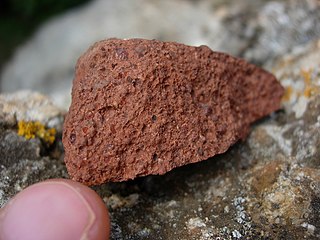
Bauxite is a sedimentary rock with a relatively high aluminium content. It is the world's main source of aluminium and gallium. Bauxite consists mostly of the aluminium minerals gibbsite, boehmite and diaspore, mixed with the two iron oxides goethite and haematite, the aluminium clay mineral kaolinite and small amounts of anatase and ilmenite . Bauxite appears dull in luster and is reddish-brown, white, or tan.

Cedar City is the largest city in Iron County, Utah, United States. Located 250 miles (400 km) south of Salt Lake City, it is 170 miles (270 km) north of Las Vegas on Interstate 15. Southern Utah University is located in Cedar City. It is the home of the Utah Shakespeare Festival, the Utah Summer Games, the Simon Fest Theatre Co., and other events. As of the 2020 census the city had a population of 35,235, up from 28,857 in the 2010 census.

Parowan is a city in and the county seat of Iron County, Utah, United States. The population was 2,790 at the 2010 census, and in 2018 the estimated population was 3,100.

The Ore Mountains lie along the Czech–German border, separating the historical regions of Bohemia in the Czech Republic and Saxony in Germany. The highest peaks are the Klínovec in the Czech Republic at 1,244 metres (4,081 ft) above sea level and the Fichtelberg in Germany at 1,215 metres (3,986 ft).

The Aravalli Range is a mountain range in Northern-Western India, running approximately 670 km (420 mi) in a south-west direction, starting near Delhi, passing through southern Haryana, Rajasthan, and ending in Ahmedabad Gujarat. The highest peak is Guru Shikhar on Mount Abu at 1,722 m (5,650 ft). The Aravalli Range is one of the oldest geological features on Earth, having its origin in the Proterozoic era.

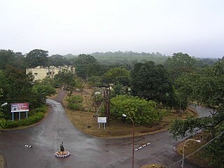
Kudremukha is the name of a mountain range and an individual mountain peak located in Chikmagalur district, in Karnataka, India. It is also the name of a small hill station and iron ore-mining town situated near the mountain, about 20 kilometres from Kalasa in Kalasa Taluk. The name Kuduremukha literally means "horse-faced" in Kannada and refers to a particular picturesque view of a side of the mountain that resembles a horse's face. It was also referred to as 'Samseparvata', historically since it was approached from Samse village. Kuduremukha is Karnataka's 2nd highest peak after Mullayanagiri and 26th highest peak in western ghats. The nearest International Airport is at Mangalore which is at a distance of 99 kilometres.
Gadchiroli ( [ɡəɖt͡ʃiɾoliː]) is a city and a municipal council in Gadchiroli district in the state of Maharashtra, central India. It is located on eastern side of Maharashtra, and is the administrative headquarters of the district. Gadchiroli is called the lung of Maharashtra as almost 70% of this district is covered by forests having 21% of the total forest cover of the state. The main river flowing through city is the Wainganga River. The landscape is lush and green during the monsoon season which is prone to flooding. Gadchiroli is known for its forests. Teak is grown commercially and bamboos are used for various crafts.
Noamundi is a census town in West Singhbhum district in the Indian state of Jharkhand. It is also an administrative block. It is a small mining town located close to the Odisha border. It lies near Jamshedpur and 64 km (40 mi) from Chaibasa. Nearby towns include Padapahar, Barajamda, jagannathpur, Kharsawan, Gua and Kiriburu.

The Guayana Region is an administrative region of eastern Venezuela.
Jadugora is a census town in the Musabani CD block in the Ghatshila subdivision of the East Singhbhum district in the Indian state of Jharkhand.

Reasi is a town and a notified area committee and tehsil in Reasi district of the Indian union territory of Jammu and Kashmir. Situated on the bank of River Chenab, It is the headquarters of the Reasi district. In the eighth century, Reasi was a part of the Bhimgarh state established by Rajput king Bhim Dev Rasyal. The name Reasi is derived from the town's old name, "Rasyal".

Uttar Bastar Kanker District is located in the southern region of the state of Chhattisgarh, India within the latitudes 20.6-20.24 and longitudes 80.48-81.48. The total area of the district is 6432 square kilometers. The population is 748,941.

Ballari, formerly Bellary, is a major district in Karnataka. It is located at north-eastern part of Karnataka. This district belongs to Kalyana-Karnataka. This district was one of the biggest districts in Karnataka until the Vijayanagara district was carved out of Ballari district in 2021 officially.
Gangamoola is a hill in the Chikkamagaluru district of the state of Karnataka, India. Also known as Varaha Parvata, it is one of the hills in the Western Ghats range and is known for being the source of three rivers, Tunga, Bhadra and Netravathi.

The Gogebic Range is an elongated area of iron ore deposits located within a range of hills in northern Michigan and Wisconsin just south of Lake Superior. It extends from Lake Namakagon in Wisconsin eastward to Lake Gogebic in Michigan, or almost 80 miles. Though long, it is only about a half mile wide and forms a crescent concave to the southeast. The Gogebic Range includes the communities of Ironwood in Michigan, plus Mellen and Hurley in Wisconsin.
The mineral industry of Russia is one of the world's leading mineral industries and accounts for a large percentage of the Commonwealth of Independent States' production of a range of mineral products, including metals, industrial minerals, and mineral fuels. In 2005, Russia ranked among the leading world producers or was a significant producer of a vast range of mineral commodities, including aluminum, arsenic, cement, copper, magnesium compounds and metals, nitrogen, palladium, silicon, nickel and vanadium.

Manganese is a ghost town and former mining community in the U.S. state of Minnesota that was inhabited between 1912 and 1960. It was built in Crow Wing County on the Cuyuna Iron Range in sections 23 and 28 of Wolford Township, about 2 miles (3 km) north of Trommald, Minnesota. After its formal dissolution, Manganese was absorbed by Wolford Township; the former town site is located between Coles Lake and Flynn Lake. First appearing in the U.S. Census of 1920 with an already dwindling population of 183, the village was abandoned by 1960.
Surjagad is a small village near Etapalli. There is a yearly festival known as 'Surjagad Yatra' in first week of January. It is a major festival for the Madia Tribes in Bhamragad and Etapalli Talukas of Gadchiroli District. Deity of God is situated in a dense forest and hilly area. This place is only accessible during this there is iron mining also.
Mount Pinpet or "Pine Tree Mountain" is a mountain in Shan State, Myanmar containing the country's second largest iron deposits. The mountain is located 7 miles southeast of Taunggyi, the capital of Shan state, and covers an area of approximately 8 square miles. The mountain stands at 1,400 meters above sea level. There are around 7,000 people that call this mountain home, most of whom belong to the Pa'O ethnic nationality.

The environmental impact of iron ore mining in all its phases from excavation to beneficiation to transportation and beyond may have detrimental effects on air quality, water quality, biological species, and nearby communities. This is predominantly a result of large-scale iron ore tailings that are released into the environment which are harmful to both animals and humans.
